
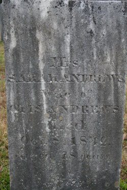
Sarah “Sally” Shaw Andrews
| Birth | : | 1764 |
| Death | : | 8 Oct 1842 Colrain, Franklin County, Massachusetts, USA |
| Burial | : | Evergreen Cemetery, Ontario, Malheur County, USA |
| Coordinate | : | 44.0167007, -116.9757996 |
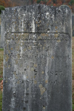
| Description | : | ___________________________________________________ She married Otis Andrews on Apr 10,1791 at Middleboro,MA. Children: 1. Lurena Andrews (1792-1875), m. Edward Davenport. 2. Salvador Andrews (1794-1837), m. Elizabeth Lyon. 3. Elizabeth Andrews (c1797-bef1844), m. Thomas Morton. 4. James Andrews (1800-1837). 5. Josiah Andrews (1802-1811). 6. Sarah Andrews (c1804-1880), m. James Sumner Ranney. NOTE: Sarah's maiden name is variously listed on the Internet as Shaw or Ranney. (It may have been the daughter Sarah that married James Sumner Ranney that leads to the confusion. Her maiden name was Shaw.) Many thanks to Sarah's 4-gr granddaughter Mary Toluchanian for providing clarifying detail on this family! |
frequently asked questions (FAQ):
-
Where is Sarah “Sally” Shaw Andrews's memorial?
Sarah “Sally” Shaw Andrews's memorial is located at: Evergreen Cemetery, Ontario, Malheur County, USA.
-
When did Sarah “Sally” Shaw Andrews death?
Sarah “Sally” Shaw Andrews death on 8 Oct 1842 in Colrain, Franklin County, Massachusetts, USA
-
Where are the coordinates of the Sarah “Sally” Shaw Andrews's memorial?
Latitude: 44.0167007
Longitude: -116.9757996
Family Members:
Spouse

Children
Flowers:


Nearby Cemetories:
1. Evergreen Cemetery
Ontario, Malheur County, USA
Coordinate: 44.0167007, -116.9757996
2. Sunset Cemetery
Ontario, Malheur County, USA
Coordinate: 44.0225080, -116.9887300
3. Corpus Christi Catholic Church Columbarium
Fruitland, Payette County, USA
Coordinate: 44.0170500, -116.9281260
4. Washoe Cemetery
Payette County, USA
Coordinate: 44.0503006, -116.9471970
5. Beckmon Burial
Payette County, USA
Coordinate: 44.0565928, -116.9159265
6. Riverside Cemetery
Payette, Payette County, USA
Coordinate: 44.0952988, -116.9349976
7. Rosedale Memorial Gardens
Payette, Payette County, USA
Coordinate: 44.0902820, -116.9116120
8. Park View Cemetery
New Plymouth, Payette County, USA
Coordinate: 43.9761009, -116.8424988
9. Applegate Cemetery
Malheur County, USA
Coordinate: 44.1266600, -116.9298100
10. Applegate-Kennedy Cemetery
New Plymouth, Payette County, USA
Coordinate: 43.9749985, -116.7908020
11. Hilltop Memorial Cemetery
Nyssa, Malheur County, USA
Coordinate: 43.8834010, -117.0481340
12. Pioneer Cemetery
Vale, Malheur County, USA
Coordinate: 43.9994011, -117.2397003
13. Henderson Grave
Vale, Malheur County, USA
Coordinate: 43.9725500, -117.2359000
14. Valley View Cemetery
Vale, Malheur County, USA
Coordinate: 43.9972000, -117.2435989
15. Falk Cemetery
Payette County, USA
Coordinate: 43.9227982, -116.7343979
16. Fairview Cemetery
Ontario, Malheur County, USA
Coordinate: 44.2181015, -116.9847031
17. Parma Cemetery
Parma, Canyon County, USA
Coordinate: 43.7919006, -116.9511032
18. Owyhee River Cemetery
Owyhee, Malheur County, USA
Coordinate: 43.7956800, -117.0516300
19. Galloway Cemetery
Weiser, Washington County, USA
Coordinate: 44.2372017, -116.8869019
20. Owyhee Cemetery
Nyssa, Malheur County, USA
Coordinate: 43.7957993, -117.0847015
21. Hillcrest Cemetery
Weiser, Washington County, USA
Coordinate: 44.2585983, -116.9638290
22. Owyhee Pioneer Cemetery
Owyhee, Malheur County, USA
Coordinate: 43.7762500, -117.0787700
23. Lower Boise Cemetery
Parma, Canyon County, USA
Coordinate: 43.7599983, -116.8833008
24. Roswell Cemetery
Roswell, Canyon County, USA
Coordinate: 43.7435989, -116.9702988