

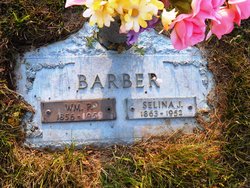
Selina Elmira “Lina” Taylor Barber
| Birth | : | 22 Jan 1863 Bourbonnais, Kankakee County, Illinois, USA |
| Death | : | 29 Dec 1952 Spencer, Clay County, Iowa, USA |
| Burial | : | North Lawn Cemetery, Spencer, Clay County, USA |
| Coordinate | : | 43.1600000, -95.1470000 |
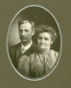
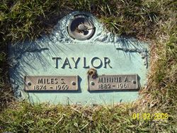
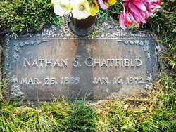
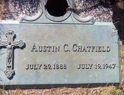
| Description | : | Daughter of MILES STUART TAYLOR & SELINAH JANE BRATTON aka: Selina(h) Elmira "Lina" TAYLOR Note: the middle initial J. on her headstone may be in error; her marriage and 1930 census records reflect an E; born: Jan 22, 1862 Married (1): Aug 30, 1883, CHARLES HENRY CHATFIELD, Kankakee, Kankakee Co., Illinois Two children: 1. Nathan Stuart CHATFIELD 1885 - 1972 2. Austin Charles CHATFIELD 1888 - 1947 Married (2): Oct 7, 1896, WILLIAM PROSPER BARBER, Kankakee Co., Illinois |
frequently asked questions (FAQ):
-
Where is Selina Elmira “Lina” Taylor Barber's memorial?
Selina Elmira “Lina” Taylor Barber's memorial is located at: North Lawn Cemetery, Spencer, Clay County, USA.
-
When did Selina Elmira “Lina” Taylor Barber death?
Selina Elmira “Lina” Taylor Barber death on 29 Dec 1952 in Spencer, Clay County, Iowa, USA
-
Where are the coordinates of the Selina Elmira “Lina” Taylor Barber's memorial?
Latitude: 43.1600000
Longitude: -95.1470000
Family Members:
Parent
Spouse
Siblings

Children
Flowers:


Nearby Cemetories:
1. North Lawn Cemetery
Spencer, Clay County, USA
Coordinate: 43.1600000, -95.1470000
2. Dewey Readmore Books Memorial
Spencer, Clay County, USA
Coordinate: 43.1403999, -95.1443024
3. Riverside Cemetery
Spencer, Clay County, USA
Coordinate: 43.1441994, -95.1671982
4. Fairview Cemetery
Clay County, USA
Coordinate: 43.1899986, -95.0800018
5. Evergreen Cemetery
Clay County, USA
Coordinate: 43.2052994, -95.2086029
6. Dickens Cemetery
Dickens, Clay County, USA
Coordinate: 43.1280000, -95.0155000
7. Swedish Lutheran Cemetery
Royal, Clay County, USA
Coordinate: 43.0683000, -95.2350000
8. Little Sioux Lutheran Cemetery
Milford, Dickinson County, USA
Coordinate: 43.2702065, -95.2109528
9. Rosehill Cemetery
Clay County, USA
Coordinate: 43.0368996, -95.0919037
10. First Reformed Cemetery
Clay County, USA
Coordinate: 43.2399500, -95.2889000
11. Lone Tree Cemetery
Everly, Clay County, USA
Coordinate: 43.1411018, -95.3347015
12. Milford Cemetery
Milford, Dickinson County, USA
Coordinate: 43.3092003, -95.1481018
13. Lincoln Cemetery
Rossie, Clay County, USA
Coordinate: 43.0111008, -95.2313995
14. Calvary Cemetery
Milford, Dickinson County, USA
Coordinate: 43.3213997, -95.1688995
15. Logan Township Cemetery
Clay County, USA
Coordinate: 43.0489006, -94.9747009
16. Liberty Cemetery
Greenville, Clay County, USA
Coordinate: 42.9897003, -95.1417007
17. Willow Creek Cemetery
Royal, Clay County, USA
Coordinate: 43.0214005, -95.2885971
18. Clay Center Cemetery
Royal, Clay County, USA
Coordinate: 43.0410995, -95.3272018
19. TriMello Cemetery
Royal, Clay County, USA
Coordinate: 43.0682983, -95.3728027
20. Crown Hill Cemetery
Ruthven, Palo Alto County, USA
Coordinate: 43.1328011, -94.8878021
21. Calvary Cemetery
Ruthven, Palo Alto County, USA
Coordinate: 43.1314011, -94.8869019
22. Zion Methodist Cemetery
Clay County, USA
Coordinate: 42.9808006, -95.2497025
23. Westport Cemetery
Dickinson County, USA
Coordinate: 43.3130989, -95.3289032
24. Okoboji Cemetery
Arnolds Park, Dickinson County, USA
Coordinate: 43.3649406, -95.1303558