
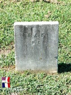

Sgt Frederick A Buchanan
| Birth | : | 1839 Anson County, North Carolina, USA |
| Death | : | 4 May 1863 Chancellorsville, Spotsylvania County, Virginia, USA |
| Burial | : | Saint Joseph Cemetery, Keene, Cheshire County, USA |
| Coordinate | : | 42.9158700, -72.2717900 |
| Plot | : | Section 13, Row 2, Grave 10 |
| Inscription | : | North Carolina |
| Description | : | Company C "Anson Guard" of Anson County, 14th North Carolina Infantry, Ramseur's Brigade, Army of Northern Virginia, C.S.A. Residence Anson County NC; a 22 year-old Farmer. Enlisted on 4/22/1861 at Anson County, NC as a Sergeant, he mustered into "C" Co. NC 14th Infantry. Reduced 4/25/1862 to ranks, Private. Wounded 9/17/1862 Sharpsburg, MD.; returned 1/1863. Mortally Wounded In Action 5/3/1863 in the Battle of Chancellorsville, VA. The 14th North Carolina Infantry Regiment, formerly the 4th Volunteers, completed its organization in June, 1861, at Garysburg, North Carolina. The 14th participated in the various campaigns of the Confederate Army from... Read More |
frequently asked questions (FAQ):
-
Where is Sgt Frederick A Buchanan's memorial?
Sgt Frederick A Buchanan's memorial is located at: Saint Joseph Cemetery, Keene, Cheshire County, USA.
-
When did Sgt Frederick A Buchanan death?
Sgt Frederick A Buchanan death on 4 May 1863 in Chancellorsville, Spotsylvania County, Virginia, USA
-
Where are the coordinates of the Sgt Frederick A Buchanan's memorial?
Latitude: 42.9158700
Longitude: -72.2717900
Family Members:
Parent
Siblings
Flowers:


Nearby Cemetories:
1. Saint Joseph Cemetery
Keene, Cheshire County, USA
Coordinate: 42.9158700, -72.2717900
2. Saint James Episcopal Church Columbarium
Keene, Cheshire County, USA
Coordinate: 42.9334099, -72.2793505
3. Washington Cemetery
Keene, Cheshire County, USA
Coordinate: 42.9367750, -72.2765080
4. Greenlawn Cemetery
Keene, Cheshire County, USA
Coordinate: 42.9402100, -72.2750300
5. Woodland Cemetery
Keene, Cheshire County, USA
Coordinate: 42.9404755, -72.2700806
6. Ash Swamp Burying Ground
Keene, Cheshire County, USA
Coordinate: 42.9294100, -72.3153800
7. West Cemetery
Keene, Cheshire County, USA
Coordinate: 42.9376200, -72.3165600
8. Nye Burying Ground
Roxbury Center, Cheshire County, USA
Coordinate: 42.9393600, -72.2266900
9. Mount Calvary Cemetery
Marlborough, Cheshire County, USA
Coordinate: 42.9060900, -72.2136300
10. Mount Caesar Cemetery
Swanzey, Cheshire County, USA
Coordinate: 42.8727200, -72.2818000
11. Estey Cemetery
Marlborough, Cheshire County, USA
Coordinate: 42.8971000, -72.2113000
12. Pine Grove Cemetery
Marlborough, Cheshire County, USA
Coordinate: 42.9057100, -72.2073000
13. Graniteville Cemetery
Marlborough, Cheshire County, USA
Coordinate: 42.9057000, -72.2073000
14. North Cemetery
Keene, Cheshire County, USA
Coordinate: 42.9595100, -72.3013900
15. Monadnock View Cemetery
Keene, Cheshire County, USA
Coordinate: 42.9516983, -72.3169022
16. Mountain View Cemetery
Swanzey, Cheshire County, USA
Coordinate: 42.8602100, -72.2803900
17. Oak Hill Cemetery
West Swanzey, Cheshire County, USA
Coordinate: 42.8721800, -72.3213200
18. Hillside Cemetery
Roxbury Center, Cheshire County, USA
Coordinate: 42.9534360, -72.2117930
19. Homestead Cemetery
West Swanzey, Cheshire County, USA
Coordinate: 42.8681940, -72.3241210
20. Meeting House Cemetery
Marlborough, Cheshire County, USA
Coordinate: 42.8856020, -72.1892240
21. Hurricane Road Cemetery
Keene, Cheshire County, USA
Coordinate: 42.9555700, -72.3594300
22. East Cemetery
Marlborough, Cheshire County, USA
Coordinate: 42.9317000, -72.1696000
23. South Cemetery
Surry, Cheshire County, USA
Coordinate: 42.9934700, -72.3113700
24. Westport Cemetery
Swanzey, Cheshire County, USA
Coordinate: 42.8463800, -72.3356300