
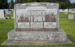
SGT John Edward Boyle Jr.
| Birth | : | 26 Feb 1921 North Platte, Lincoln County, Nebraska, USA |
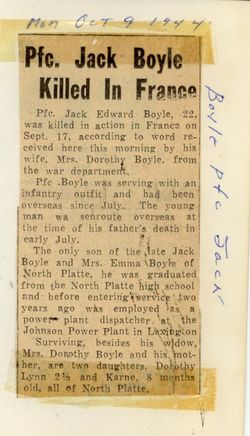
| Death | : | 18 Sep 1944 France |
| Burial | : | Davis Cemetery, Davis, Tucker County, USA |
| Coordinate | : | 39.1257280, -79.4786820 |
| Description | : | Husband of Dorothy Boyle, father of Dorothy Lynn and Karen Boyle. Killed in France during the invasion of Normandy in World War II. Sgt Boyle who had been a private first class, had received a field promotion to the rank of sergeant, preceding his death. |
frequently asked questions (FAQ):
-
Where is SGT John Edward Boyle Jr.'s memorial?
SGT John Edward Boyle Jr.'s memorial is located at: Davis Cemetery, Davis, Tucker County, USA.
-
When did SGT John Edward Boyle Jr. death?
SGT John Edward Boyle Jr. death on 18 Sep 1944 in France
-
Where are the coordinates of the SGT John Edward Boyle Jr.'s memorial?
Latitude: 39.1257280
Longitude: -79.4786820
Family Members:
Parent

Siblings
Flowers:


Nearby Cemetories:
1. Davis Cemetery
Davis, Tucker County, USA
Coordinate: 39.1257280, -79.4786820
2. Mount Calvary Cemetery
Thomas, Tucker County, USA
Coordinate: 39.1474991, -79.4916992
3. Rose Hill Cemetery
Thomas, Tucker County, USA
Coordinate: 39.1504000, -79.5035000
4. Cortland Cemetery
Cortland, Tucker County, USA
Coordinate: 39.0581017, -79.4360962
5. Close Mountain Cemetery
Tucker County, USA
Coordinate: 39.1758200, -79.5716670
6. Nine Cemetery
Tucker County, USA
Coordinate: 39.0254500, -79.4642930
7. Kight Cemetery
Preston County, USA
Coordinate: 39.2218160, -79.5223730
8. Sugarlands Brethren Church Cemetery
Thomas, Tucker County, USA
Coordinate: 39.1369170, -79.6102830
9. Pine Grove Cemetery
Lead Mine, Tucker County, USA
Coordinate: 39.1931000, -79.5835000
10. Buena Chapel Cemetery
Canaan Heights, Tucker County, USA
Coordinate: 39.0223200, -79.4438200
11. Carr-White Cemetery
Tucker County, USA
Coordinate: 39.0234100, -79.5201220
12. Brights Chapel Cemetery
Elk, Tucker County, USA
Coordinate: 39.0201000, -79.5312400
13. Clark-Carr Cemetery
Red Creek, Tucker County, USA
Coordinate: 39.0240580, -79.5434710
14. Shaffertown Cemetery
Lead Mine, Tucker County, USA
Coordinate: 39.2175730, -79.5669040
15. Helmick
Dobbin, Grant County, USA
Coordinate: 39.2379970, -79.4156120
16. Hile Cemetery
Tucker County, USA
Coordinate: 39.1946983, -79.6093979
17. James M Wilkins Cemetery
Dobbin, Grant County, USA
Coordinate: 39.2388734, -79.4154218
18. Flanagan Hill Cemetery
Red Creek, Tucker County, USA
Coordinate: 39.0013400, -79.4964020
19. Dobbin Cemetery
Garrett County, USA
Coordinate: 39.2421425, -79.4159961
20. Fansler Cemetery
Hendricks, Tucker County, USA
Coordinate: 39.0800018, -79.6316986
21. Bonnifield Cemetery
Saint George, Tucker County, USA
Coordinate: 39.1617012, -79.6386032
22. Old Ault Family Cemetery
Red Creek, Tucker County, USA
Coordinate: 38.9962140, -79.5075670
23. McNeeley Cemetery
Hendricks, Tucker County, USA
Coordinate: 39.0786018, -79.6378021
24. Collett Cemetery
Hambleton, Tucker County, USA
Coordinate: 39.0844002, -79.6410980