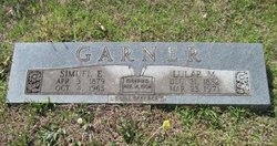
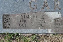
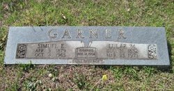
Simuel Edward Garner
| Birth | : | 3 Apr 1879 Ashley County, Arkansas, USA |
| Death | : | 4 Oct 1965 El Dorado, Union County, Arkansas, USA |
| Burial | : | Union Cemetery, De Kalb, St. Lawrence County, USA |
| Coordinate | : | 44.5341988, -75.2881012 |
| Description | : | Married April 14, 1904. |
frequently asked questions (FAQ):
-
Where is Simuel Edward Garner's memorial?
Simuel Edward Garner's memorial is located at: Union Cemetery, De Kalb, St. Lawrence County, USA.
-
When did Simuel Edward Garner death?
Simuel Edward Garner death on 4 Oct 1965 in El Dorado, Union County, Arkansas, USA
-
Where are the coordinates of the Simuel Edward Garner's memorial?
Latitude: 44.5341988
Longitude: -75.2881012
Family Members:
Parent
Spouse
Siblings
Children
Flowers:
Nearby Cemetories:
1. Union Cemetery
De Kalb, St. Lawrence County, USA
Coordinate: 44.5341988, -75.2881012
2. Saint Henrys Cemetery
De Kalb, St. Lawrence County, USA
Coordinate: 44.5139008, -75.2649994
3. Jerusalem Cemetery
Eddy, St. Lawrence County, USA
Coordinate: 44.5428009, -75.2397003
4. Kendrew Cemetery
De Kalb, St. Lawrence County, USA
Coordinate: 44.5480995, -75.3414001
5. East DeKalb Cemetery
De Kalb Junction, St. Lawrence County, USA
Coordinate: 44.4850006, -75.3024979
6. Old Pioneer Cemetery
De Kalb, St. Lawrence County, USA
Coordinate: 44.4993591, -75.3454666
7. Old DeKalb Cemetery
De Kalb, St. Lawrence County, USA
Coordinate: 44.5010986, -75.3494034
8. Rensselaer Falls Cemetery
Rensselaer Falls, St. Lawrence County, USA
Coordinate: 44.5860901, -75.3164902
9. Walruth Cemetery
Rensselaer Falls, St. Lawrence County, USA
Coordinate: 44.6124992, -75.3135986
10. Hermon Cemetery
Hermon, St. Lawrence County, USA
Coordinate: 44.4621260, -75.2249980
11. Old Hermon Cemetery
Hermon, St. Lawrence County, USA
Coordinate: 44.4613610, -75.2252020
12. Foote Family Cemetery
Canton, St. Lawrence County, USA
Coordinate: 44.5891220, -75.1957080
13. Mount Lona Cemetery
Heuvelton, St. Lawrence County, USA
Coordinate: 44.5942001, -75.3764038
14. Marshville Cemetery
Hermon, St. Lawrence County, USA
Coordinate: 44.4536438, -75.2314148
15. East Road Cemetery
De Peyster, St. Lawrence County, USA
Coordinate: 44.5505981, -75.4147034
16. Grandy Homestead Cemetery
Russell, St. Lawrence County, USA
Coordinate: 44.4769402, -75.1859818
17. West Hermon Cemetery
Hermon, St. Lawrence County, USA
Coordinate: 44.4413986, -75.3035965
18. Saint Lawrence County Alms House Cemetery
Canton, St. Lawrence County, USA
Coordinate: 44.6126580, -75.2118570
19. Fairview Cemetery
Canton, St. Lawrence County, USA
Coordinate: 44.5800018, -75.1688995
20. Norton Cemetery
Canton, St. Lawrence County, USA
Coordinate: 44.6225014, -75.2311020
21. Old Canton Cemetery
Canton, St. Lawrence County, USA
Coordinate: 44.5922012, -75.1697006
22. Unitarian Universalist Memorial Garden
Canton, St. Lawrence County, USA
Coordinate: 44.5959730, -75.1677820
23. Saint Marys Cemetery
Canton, St. Lawrence County, USA
Coordinate: 44.6074982, -75.1806030
24. King Cemetery
Canton, St. Lawrence County, USA
Coordinate: 44.5306015, -75.1346970

