| Birth | : | 10 Apr 1825 Wayne City, Wayne County, Illinois, USA |
| Death | : | 29 Sep 1874 Maysville, Scott County, Iowa, USA |
| Burial | : | Scranton Township Cemetery, Scranton, Greene County, USA |
| Coordinate | : | 42.0306015, -94.5783005 |
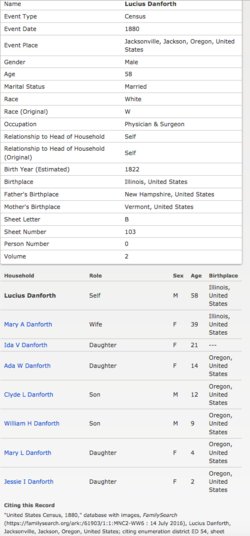
| Description | : | Sophia Wells married Lucius Danforth in 1844 and had daughter Hellen in 1845. 1847, Wagon Train roster includes Joseph, Rosalinda, Manley, his wife, Joseph's son Lucius, his wife Sophia, their daughter Hellen, Joseph's daughter, Sarah. 1848, Aug. 8, Joseph, Manley, Lucius and Elias J. Crandall filed land claims in Yamhill Co. 1849 Lucius, Sophia & Hellen returned to Rock Island Co., Ill.; second daughter, Edith was born in June 1850; Lucius returned to Oregon in Sept. 1852 but Sophia and the girls did not go with him. 1850 Census of Illinois, Rock Island Co., Oct. 10, 1850 has Lucius (age... Read More |
frequently asked questions (FAQ):
-
Where is Sophia A. Wells Danforth Sayre's memorial?
Sophia A. Wells Danforth Sayre's memorial is located at: Scranton Township Cemetery, Scranton, Greene County, USA.
-
When did Sophia A. Wells Danforth Sayre death?
Sophia A. Wells Danforth Sayre death on 29 Sep 1874 in Maysville, Scott County, Iowa, USA
-
Where are the coordinates of the Sophia A. Wells Danforth Sayre's memorial?
Latitude: 42.0306015
Longitude: -94.5783005
Family Members:
Parent
Spouse
Siblings
Flowers:
Nearby Cemetories:
1. Dillavou Cemetery
Kendrick Township, Greene County, USA
Coordinate: 42.0802994, -94.6138992
2. Gibson-Fleck-Thompson Cemetery
Scranton, Greene County, USA
Coordinate: 42.0428870, -94.4988800
3. Wright Cemetery
Jefferson, Greene County, USA
Coordinate: 42.0228004, -94.4477997
4. Fair Oaks Cemetery
Scranton, Greene County, USA
Coordinate: 42.0355988, -94.4460983
5. Headley Cemetery
Jefferson, Greene County, USA
Coordinate: 42.0041504, -94.4335815
6. Dickson Cemetery
Glidden Township, Carroll County, USA
Coordinate: 42.1074982, -94.6939011
7. North Coon Cemetery
Carroll County, USA
Coordinate: 42.1260986, -94.6716995
8. Willow Cemetery
Greene County, USA
Coordinate: 41.9067001, -94.5730972
9. West Lawn Cemetery
Glidden, Carroll County, USA
Coordinate: 42.0649986, -94.7406006
10. Saint Patricks Cemetery
Churdan, Greene County, USA
Coordinate: 42.1605988, -94.5511017
11. Highland Township Cemetery
Churdan, Greene County, USA
Coordinate: 42.1518310, -94.4699120
12. Saint Joseph Cemetery
Jefferson, Greene County, USA
Coordinate: 42.0289001, -94.3818970
13. Union Township Cemetery
Coon Rapids, Carroll County, USA
Coordinate: 41.8781013, -94.6389008
14. Old Cedar Cemetery
Adaza, Greene County, USA
Coordinate: 42.1874821, -94.5419194
15. Old Carrollton Cemetery
Carrollton, Carroll County, USA
Coordinate: 41.9233017, -94.7403030
16. Jefferson Cemetery
Jefferson, Greene County, USA
Coordinate: 42.0133018, -94.3591995
17. Oak Hill Cemetery
Coon Rapids, Carroll County, USA
Coordinate: 41.9053001, -94.7200012
18. McCurdy Cemetery
Carroll County, USA
Coordinate: 41.9403000, -94.7649994
19. Coon Rapids Cemetery
Coon Rapids, Carroll County, USA
Coordinate: 41.8778000, -94.6678009
20. Greenbrier Cemetery
Cooper, Greene County, USA
Coordinate: 41.9063988, -94.4218979
21. Holy Family Cemetery
Lidderdale, Carroll County, USA
Coordinate: 42.1178017, -94.7839966
22. Lanesboro Cemetery
Lanesboro, Carroll County, USA
Coordinate: 42.1810989, -94.7230988
23. Saint Marys Catholic Cemetery
Willey, Carroll County, USA
Coordinate: 41.9783363, -94.8212204
24. East Liberty Cemetery
Lidderdale, Carroll County, USA
Coordinate: 42.1591988, -94.7636032


