
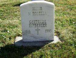

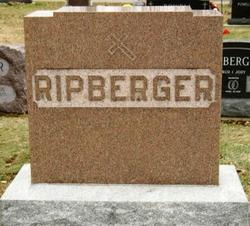
Sr Gertrude Josephine “Mary Rosella” Ripberger CSJ
| Birth | : | 25 Dec 1916 Tipton County, Indiana, USA |
| Death | : | 25 Jul 1995 Tipton, Tipton County, Indiana, USA |
| Burial | : | Cedar Hill Cemetery, Hartford, Hartford County, USA |
| Coordinate | : | 41.7230988, -72.6999969 |
| Inscription | : | Gertrude Ripberger |
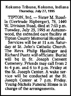
| Description | : | Sister M.Rosella (Gertrude Ripberger), 78, 1440 W. Division Road, died at 7:43 p.m. Tuesday, July 25,1995 at Autumnwood, the extended care facility at Tipton County Memorial Hospital. Services will be at 11 a.m. Saturday at St. John's Catholic Church. The Revs. Philip Haslinger and Richard Puetz will officiate. Burial will be, in St. Joseph Convent Cemetery. Friends may call from 2 to 4 p.m. and 6 to 8 p.m. Friday at the St. Joseph Center. A wake service will be conducted at the St. Joseph Center at 7 p.m. Friday. Young-Nichols Funeral Home is in charge of arrangements. |
frequently asked questions (FAQ):
-
Where is Sr Gertrude Josephine “Mary Rosella” Ripberger CSJ's memorial?
Sr Gertrude Josephine “Mary Rosella” Ripberger CSJ's memorial is located at: Cedar Hill Cemetery, Hartford, Hartford County, USA.
-
When did Sr Gertrude Josephine “Mary Rosella” Ripberger CSJ death?
Sr Gertrude Josephine “Mary Rosella” Ripberger CSJ death on 25 Jul 1995 in Tipton, Tipton County, Indiana, USA
-
Where are the coordinates of the Sr Gertrude Josephine “Mary Rosella” Ripberger CSJ's memorial?
Latitude: 41.7230988
Longitude: -72.6999969
Family Members:
Parent


Siblings


Flowers:


Nearby Cemetories:
1. Cedar Hill Cemetery
Hartford, Hartford County, USA
Coordinate: 41.7230988, -72.6999969
2. Congregation Kol Haverim Cemetery
Wethersfield, Hartford County, USA
Coordinate: 41.7193108, -72.6989594
3. Temple Beth Torah Memorial Park
Wethersfield, Hartford County, USA
Coordinate: 41.7193108, -72.6989212
4. Piaterer Verein Society Cemetery
Wethersfield, Hartford County, USA
Coordinate: 41.7193070, -72.6973570
5. Beth David Cemetery
Wethersfield, Hartford County, USA
Coordinate: 41.7185000, -72.6976000
6. Emanuel Synagogue Cemetery
Wethersfield, Hartford County, USA
Coordinate: 41.7198105, -72.6950073
7. United Synagogues Memorial Park
Wethersfield, Hartford County, USA
Coordinate: 41.7172220, -72.6994440
8. Congregation Bnai Sholom Cemetery
Wethersfield, Hartford County, USA
Coordinate: 41.7170400, -72.6955200
9. Bess Israel Cemetery
Hartford, Hartford County, USA
Coordinate: 41.7170400, -72.6955200
10. Teferes Israel Cemetery
West Hartford, Hartford County, USA
Coordinate: 41.7292252, -72.7171555
11. Beth Jacob Cemetery
West Hartford, Hartford County, USA
Coordinate: 41.7270950, -72.7204920
12. Trinity College Chapel Memorial Garden
Hartford, Hartford County, USA
Coordinate: 41.7488870, -72.6902355
13. Old South Burying Ground
Hartford, Hartford County, USA
Coordinate: 41.7472000, -72.6802979
14. Wethersfield State Prison Cemetery
Wethersfield, Hartford County, USA
Coordinate: 41.7195360, -72.6603130
15. Newington Cemetery
Newington, Hartford County, USA
Coordinate: 41.6978455, -72.7239532
16. Church of Christ Congregational Memorial Garden
Newington, Hartford County, USA
Coordinate: 41.6973190, -72.7238980
17. Temple Sinai Memorial Park
Newington, Hartford County, USA
Coordinate: 41.7188850, -72.7428170
18. Agudas Achim Cemetery
Hartford, Hartford County, USA
Coordinate: 41.7549200, -72.6915300
19. Zion Hill Cemetery
Hartford, Hartford County, USA
Coordinate: 41.7550011, -72.6917038
20. Congregation Adas Israel Cemetery
Hartford, Hartford County, USA
Coordinate: 41.7553291, -72.6898804
21. Beth Israel Cemetery
Hartford, Hartford County, USA
Coordinate: 41.7556700, -72.6893500
22. Sisters of Saint Joseph Cemetery
West Hartford, Hartford County, USA
Coordinate: 41.7549400, -72.7181091
23. West Meadow Cemetery
Newington, Hartford County, USA
Coordinate: 41.6985207, -72.7341537
24. Trinity Parish Memorial Garden
Wethersfield, Hartford County, USA
Coordinate: 41.7148190, -72.6522590