
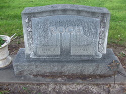
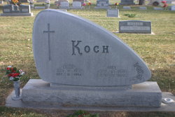
Stanley Koch
| Birth | : | 22 Nov 1895 Nebraska, USA |
| Death | : | 6 Nov 1974 North Platte, Lincoln County, Nebraska, USA |
| Burial | : | Hawley Cemetery, Hawley, Clay County, USA |
| Coordinate | : | 46.8819008, -96.3336029 |
| Description | : | buried Nov 9, 1974 Lot 1130 |
frequently asked questions (FAQ):
-
Where is Stanley Koch's memorial?
Stanley Koch's memorial is located at: Hawley Cemetery, Hawley, Clay County, USA.
-
When did Stanley Koch death?
Stanley Koch death on 6 Nov 1974 in North Platte, Lincoln County, Nebraska, USA
-
Where are the coordinates of the Stanley Koch's memorial?
Latitude: 46.8819008
Longitude: -96.3336029
Family Members:
Parent

Spouse
Siblings
Flowers:


Nearby Cemetories:
1. Hawley Cemetery
Hawley, Clay County, USA
Coordinate: 46.8819008, -96.3336029
2. Silver Lake Pioneer Cemetery
Hawley Township, Clay County, USA
Coordinate: 46.8339005, -96.3503036
3. Dale Covenant Cemetery
Eglon Township, Clay County, USA
Coordinate: 46.8913994, -96.2485962
4. Hegland Cemetery
Eglon Township, Clay County, USA
Coordinate: 46.8345604, -96.2715759
5. Spring Prairie Cemetery
Spring Prairie Township, Clay County, USA
Coordinate: 46.9319000, -96.4310989
6. Lysne Cemetery
Cromwell Township, Clay County, USA
Coordinate: 46.9639015, -96.3752975
7. Dale Immanuel Cemetery
Highland Grove Township, Clay County, USA
Coordinate: 46.9171982, -96.2169037
8. Solem Cemetery
Eglon Township, Clay County, USA
Coordinate: 46.8344800, -96.2191200
9. Spring Prairie Hutterite Cemetery
Hawley, Clay County, USA
Coordinate: 46.9406738, -96.4486283
10. Salem East Cemetery
Hitterdal, Clay County, USA
Coordinate: 46.9744800, -96.2583300
11. Salem West Cemetery
Hitterdal, Clay County, USA
Coordinate: 46.9757300, -96.2600000
12. Highland Grove Lutheran Cemetery
Highland Grove Township, Clay County, USA
Coordinate: 46.9518700, -96.2113500
13. Zion Lutheran Cemetery
Skree Township, Clay County, USA
Coordinate: 46.7722015, -96.3656006
14. Eksjo Lutheran Church Cemetery
Lake Park Township, Becker County, USA
Coordinate: 46.8779300, -96.1630700
15. Houglum Cemetery
Lake Park Township, Becker County, USA
Coordinate: 46.8317900, -96.1602900
16. Buffalo River Pioneer Cemetery
Cuba Township, Becker County, USA
Coordinate: 46.9650250, -96.1737160
17. Park Lutheran Church Cemetery
Parke Township, Clay County, USA
Coordinate: 46.7762430, -96.1875070
18. Grong Cemetery
Rollag, Clay County, USA
Coordinate: 46.7434196, -96.2380142
19. Keene Lutheran Cemetery
Keene Township, Clay County, USA
Coordinate: 47.0354400, -96.3650300
20. Rollag Lutheran Cemetery
Rollag, Clay County, USA
Coordinate: 46.7401000, -96.2386200
21. Yankee Cemetery
Parke Township, Clay County, USA
Coordinate: 46.7468080, -96.2163140
22. Lake Park Cemetery
Cuba Township, Becker County, USA
Coordinate: 46.8922005, -96.1038971
23. Saint Francis Xavier Catholic Cemetery
Cuba Township, Becker County, USA
Coordinate: 46.8922005, -96.1038971
24. Gran Lutheran Church Cemetery
Skree Township, Clay County, USA
Coordinate: 46.7179310, -96.3205290