
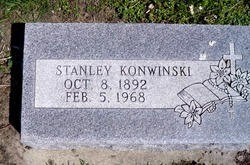
Stanley Konwinski
| Birth | : | 8 Oct 1892 Columbus, Platte County, Nebraska, USA |
| Death | : | 5 Feb 1968 Columbus, Platte County, Nebraska, USA |
| Burial | : | Holy Trinity Churchyard, Wonston, City of Winchester, England |
| Coordinate | : | 51.1531280, -1.3194670 |
| Description | : | http://www.rootsweb.ancestry.com/~neplatte/vitals/vitals1968.html The Daily Telegram, February 5, 1968 KONWINSKI--Stanley Konwinski, dies here today, rites Wednesday Stanley Konwinski, 75, of 3204 19th street, died this morning at St. Mary hospital. Last rites will take place at 9 a.m. Wednesday at St. Bonaventure church with Fr. Regis Watts officiating and burial will be in St. Bonaventure cemetery. The body will lie in state after 1 p.m. Tuesday at McKown Funeral Home, with rosary to be prayed there at 7:30 p.m. Tuesday. He was born Oct. 8, 1892, at Tarnov, the son of... Read More |
frequently asked questions (FAQ):
-
Where is Stanley Konwinski's memorial?
Stanley Konwinski's memorial is located at: Holy Trinity Churchyard, Wonston, City of Winchester, England.
-
When did Stanley Konwinski death?
Stanley Konwinski death on 5 Feb 1968 in Columbus, Platte County, Nebraska, USA
-
Where are the coordinates of the Stanley Konwinski's memorial?
Latitude: 51.1531280
Longitude: -1.3194670
Family Members:
Parent

Spouse
Siblings
Children
Flowers:


Nearby Cemetories:
1. Holy Trinity Churchyard
Wonston, City of Winchester, England
Coordinate: 51.1531280, -1.3194670
2. Hunton Cemetery
City of Winchester, England
Coordinate: 51.1540300, -1.3133700
3. St. James' Churchyard
Wonston, City of Winchester, England
Coordinate: 51.1540400, -1.3132500
4. St. Mary and St. Michael Churchyard
Stoke Charity, City of Winchester, England
Coordinate: 51.1507600, -1.3026500
5. St Michael and All Angels Churchyard
Bullington, Test Valley Borough, England
Coordinate: 51.1684730, -1.3508250
6. St. Mary the Virgin Churchyard
Micheldever, City of Winchester, England
Coordinate: 51.1491220, -1.2683430
7. All Saints Churchyard
Barton Stacey, Test Valley Borough, England
Coordinate: 51.1679344, -1.3794169
8. Lovedon Lane Burial Ground
Kings Worthy, City of Winchester, England
Coordinate: 51.0994120, -1.2958180
9. All Saints Churchyard
East Stratton, City of Winchester, England
Coordinate: 51.1573920, -1.2275280
10. St Nicholas Churchyard
Longparish, Test Valley Borough, England
Coordinate: 51.1928000, -1.3917400
11. St Catherine Churchyard Extension
Littleton, City of Winchester, England
Coordinate: 51.0936165, -1.3538719
12. St Catherine of Alexandria church
Littleton, City of Winchester, England
Coordinate: 51.0935748, -1.3538420
13. St Mary Churchyard
Crawley, City of Winchester, England
Coordinate: 51.1112870, -1.3955080
14. Crawley Cemetery
Crawley, City of Winchester, England
Coordinate: 51.1093760, -1.3977960
15. St Mary Churchyard
Kings Worthy, City of Winchester, England
Coordinate: 51.0882590, -1.2977040
16. St Mary Churchyard
Tufton, Basingstoke and Deane Borough, England
Coordinate: 51.2185300, -1.3463600
17. St Swithun Churchyard
Headbourne Worthy, City of Winchester, England
Coordinate: 51.0851610, -1.3055710
18. St Swithun Churchyard
Martyr Worthy, City of Winchester, England
Coordinate: 51.0919540, -1.2648440
19. St Mary Churchyard
Easton, City of Winchester, England
Coordinate: 51.0873090, -1.2743220
20. St. Andrew's Churchyard
Hurstbourne Priors, Basingstoke and Deane Borough, England
Coordinate: 51.2174800, -1.3729100
21. St Mary the Less Churchyard
Chilbolton, Test Valley Borough, England
Coordinate: 51.1599200, -1.4364900
22. All Hallows Churchyard
Whitchurch, Basingstoke and Deane Borough, England
Coordinate: 51.2270580, -1.3427600
23. Whitchurch Cemetery
Whitchurch, Basingstoke and Deane Borough, England
Coordinate: 51.2270150, -1.3456120
24. St. Peter and Holy Cross Churchyard
Wherwell, Test Valley Borough, England
Coordinate: 51.1652250, -1.4416910