
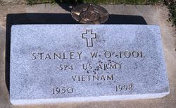
Stanley W. O'Tool
| Birth | : | 29 Apr 1950 Carroll, Carroll County, Iowa, USA |
| Death | : | 7 Dec 1998 Scottsdale, Maricopa County, Arizona, USA |
| Burial | : | Saint Marys Cemetery, Sac County, USA |
| Coordinate | : | 42.2611008, -94.8839035 |
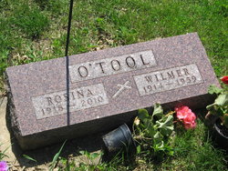
| Description | : | Stanley W. O'Tool 1950-1998 The Carroll Daily Times Herald, December 11, 1998 Stanley W. O'Tool, 48, of Scottsdale, Ariz., and formerly of Carroll, where he manage the Circle B Lumber Co., died Monday, Dec. 7, 1998, at Scottsdale Memorial Hospital South in Scottsdale. Mass of the Christian burial will be celebrated at 10:30 a.m., Saturday, Dec. 12, 1998, at Holy Spirit Catholic Church in Carroll. The celebrant will be Father James McCormick. Gift bearers will be Rosina O'Tool and Leonard and Lucille Fischer. Eucharistic minister will be Joseph O'Tool and lector will be Marlene O'Tool. Burial will be at St. Mary Cemetery in Auburn. Born... Read More |
frequently asked questions (FAQ):
-
Where is Stanley W. O'Tool's memorial?
Stanley W. O'Tool's memorial is located at: Saint Marys Cemetery, Sac County, USA.
-
When did Stanley W. O'Tool death?
Stanley W. O'Tool death on 7 Dec 1998 in Scottsdale, Maricopa County, Arizona, USA
-
Where are the coordinates of the Stanley W. O'Tool's memorial?
Latitude: 42.2611008
Longitude: -94.8839035
Family Members:
Parent

Siblings

Flowers:


Nearby Cemetories:
1. Saint Marys Cemetery
Sac County, USA
Coordinate: 42.2611008, -94.8839035
2. Oak Lawn Cemetery
Auburn, Sac County, USA
Coordinate: 42.2611008, -94.8852997
3. Grant City Cemetery
Grant City, Sac County, USA
Coordinate: 42.2681007, -94.8908005
4. Luckow Cemetery
Auburn, Sac County, USA
Coordinate: 42.2168999, -94.9266968
5. Cottonwood Cemetery
Lake City, Calhoun County, USA
Coordinate: 42.2491989, -94.7936020
6. Saint Peters Lutheran Cemetery
Sac County, USA
Coordinate: 42.3543000, -94.8868000
7. Lake City Cemetery
Lake City, Calhoun County, USA
Coordinate: 42.2719002, -94.7574997
8. Saint Marys Catholic Cemetery
Lake City, Calhoun County, USA
Coordinate: 42.2730000, -94.7567000
9. Immanuel Presbyterian Cemetery
Carnarvon, Sac County, USA
Coordinate: 42.2392006, -95.0224991
10. Saint Bernards Cemetery
Breda, Carroll County, USA
Coordinate: 42.1786003, -94.9732971
11. Our Lady Of Mount Carmel Cemetery
Mount Carmel, Carroll County, USA
Coordinate: 42.1547012, -94.9088974
12. Lutheran Emanuel Cemetery
Coon Valley Township, Sac County, USA
Coordinate: 42.3692017, -94.8771973
13. Ferguson Cemetery
Lake View, Sac County, USA
Coordinate: 42.3142014, -95.0132980
14. East Liberty Cemetery
Lidderdale, Carroll County, USA
Coordinate: 42.1591988, -94.7636032
15. Immanuel Cemetery
Lidderdale, Carroll County, USA
Coordinate: 42.1389008, -94.8022003
16. Lanesboro Cemetery
Lanesboro, Carroll County, USA
Coordinate: 42.1810989, -94.7230988
17. Wall Lake Cemetery
Wall Lake, Sac County, USA
Coordinate: 42.2757988, -95.0805969
18. Cory Grove Cemetery
Sac City, Sac County, USA
Coordinate: 42.3932991, -94.9788971
19. Wheatland Cemetery
Carroll County, USA
Coordinate: 42.1814003, -95.0582962
20. South Wall Lake Cemetery
Wall Lake, Sac County, USA
Coordinate: 42.2318993, -95.0911026
21. Holy Family Cemetery
Lidderdale, Carroll County, USA
Coordinate: 42.1178017, -94.7839966
22. Saint Francis Cemetery
Maple River, Carroll County, USA
Coordinate: 42.0969009, -94.9372025
23. Garfield Cemetery
Calhoun County, USA
Coordinate: 42.4275017, -94.7902985
24. Bishop Cemetery
Calhoun Township, Calhoun County, USA
Coordinate: 42.2230400, -94.6453190