
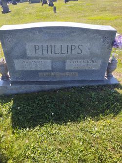
Stella Alma Mitchell Phillips
| Birth | : | 16 Dec 1897 Floyd County, Virginia, USA |
| Death | : | 18 Apr 1962 Floyd County, Virginia, USA |
| Burial | : | Fairview Cemetery, Ontario, Malheur County, USA |
| Coordinate | : | 44.2181015, -116.9847031 |
frequently asked questions (FAQ):
-
Where is Stella Alma Mitchell Phillips's memorial?
Stella Alma Mitchell Phillips's memorial is located at: Fairview Cemetery, Ontario, Malheur County, USA.
-
When did Stella Alma Mitchell Phillips death?
Stella Alma Mitchell Phillips death on 18 Apr 1962 in Floyd County, Virginia, USA
-
Where are the coordinates of the Stella Alma Mitchell Phillips's memorial?
Latitude: 44.2181015
Longitude: -116.9847031
Family Members:
Spouse

Children

Flowers:


Nearby Cemetories:
1. Fairview Cemetery
Ontario, Malheur County, USA
Coordinate: 44.2181015, -116.9847031
2. Hillcrest Cemetery
Weiser, Washington County, USA
Coordinate: 44.2585983, -116.9638290
3. Galloway Cemetery
Weiser, Washington County, USA
Coordinate: 44.2372017, -116.8869019
4. Applegate Cemetery
Malheur County, USA
Coordinate: 44.1266600, -116.9298100
5. Riverside Cemetery
Payette, Payette County, USA
Coordinate: 44.0952988, -116.9349976
6. Rosedale Memorial Gardens
Payette, Payette County, USA
Coordinate: 44.0902820, -116.9116120
7. Beckmon Burial
Payette County, USA
Coordinate: 44.0565928, -116.9159265
8. Washoe Cemetery
Payette County, USA
Coordinate: 44.0503006, -116.9471970
9. Mann Creek Cemetery
Weiser, Washington County, USA
Coordinate: 44.3669014, -116.8688965
10. Sunset Cemetery
Ontario, Malheur County, USA
Coordinate: 44.0225080, -116.9887300
11. Evergreen Cemetery
Ontario, Malheur County, USA
Coordinate: 44.0167007, -116.9757996
12. Corpus Christi Catholic Church Columbarium
Fruitland, Payette County, USA
Coordinate: 44.0170500, -116.9281260
13. Van Ornum Massacre Site
Baker County, USA
Coordinate: 44.3339330, -117.2456320
14. Old Oregon Trail Cemetery
Huntington, Baker County, USA
Coordinate: 44.3439200, -117.2529000
15. Pioneer Cemetery
Huntington, Baker County, USA
Coordinate: 44.3480500, -117.2695900
16. Park View Cemetery
New Plymouth, Payette County, USA
Coordinate: 43.9761009, -116.8424988
17. Applegate-Kennedy Cemetery
New Plymouth, Payette County, USA
Coordinate: 43.9749985, -116.7908020
18. Pioneer Cemetery
Vale, Malheur County, USA
Coordinate: 43.9994011, -117.2397003
19. Valley View Cemetery
Vale, Malheur County, USA
Coordinate: 43.9972000, -117.2435989
20. Keithley Creek Cemetery
Midvale, Washington County, USA
Coordinate: 44.4769096, -116.7839813
21. Henderson Grave
Vale, Malheur County, USA
Coordinate: 43.9725500, -117.2359000
22. Lime-Dixie Cemetery
Baker County, USA
Coordinate: 44.4235992, -117.3013992
23. Hibbard Creek Cemetery
Baker County, USA
Coordinate: 44.4999890, -117.2003590
24. Dell Cemetery
Jamieson, Malheur County, USA
Coordinate: 44.1777992, -117.4332962