

Stella Pauline Cooper Bayne
| Birth | : | 27 Nov 1922 South Bend, St. Joseph County, Indiana, USA |
| Death | : | 20 Feb 1986 Rochester, Fulton County, Indiana, USA |
| Burial | : | Saint Patricks Cemetery, Northbridge, Worcester County, USA |
| Coordinate | : | 42.1292000, -71.6457977 |
| Plot | : | Section 12, Row 5 |
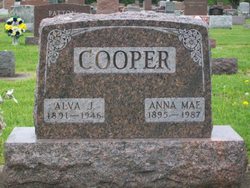
| Description | : | Published in the Rochester(IN) Sentinel, Thursday, February 20, 1986 Stella Pauline "Peenie" BAYNE, 63, Four Seasons Mobile Home Court, Lot 78, died about 9:45 a.m. today at her home of an apparent coronary attack. She was born Nov. 27, 1922 in South Bend to Jona Alva and Anna Mae HOLLOWAY COOPER, and had lived most of her life in this area. She was married to Delbert REED, James CLEMENS and James BAYNE, all of whom survive. She was a former employee of Torin Corp., and had managed the Moose Lodge dining area for many years. She was a member of... Read More |
frequently asked questions (FAQ):
-
Where is Stella Pauline Cooper Bayne's memorial?
Stella Pauline Cooper Bayne's memorial is located at: Saint Patricks Cemetery, Northbridge, Worcester County, USA.
-
When did Stella Pauline Cooper Bayne death?
Stella Pauline Cooper Bayne death on 20 Feb 1986 in Rochester, Fulton County, Indiana, USA
-
Where are the coordinates of the Stella Pauline Cooper Bayne's memorial?
Latitude: 42.1292000
Longitude: -71.6457977
Family Members:
Parent

Spouse

Siblings
Flowers:


Nearby Cemetories:
1. Saint Patricks Cemetery
Northbridge, Worcester County, USA
Coordinate: 42.1292000, -71.6457977
2. Plummer Avenue Cemetery
Northbridge, Worcester County, USA
Coordinate: 42.1273887, -71.6447787
3. Benson Cemetery
Northbridge, Worcester County, USA
Coordinate: 42.1359220, -71.6470820
4. Riverdale Cemetery
Northbridge, Worcester County, USA
Coordinate: 42.1366300, -71.6469300
5. Friends Cemetery
Northbridge, Worcester County, USA
Coordinate: 42.1303300, -71.6351100
6. Old Quaker Yard
Northbridge, Worcester County, USA
Coordinate: 42.1249600, -71.6305300
7. Fowler Cemetery
Northbridge, Worcester County, USA
Coordinate: 42.1463320, -71.6390170
8. Cooper Road Cemetery
Northbridge, Worcester County, USA
Coordinate: 42.1433790, -71.6636470
9. Old Cemetery
Northbridge, Worcester County, USA
Coordinate: 42.1326040, -71.6723420
10. Pine Grove Cemetery
Northbridge, Worcester County, USA
Coordinate: 42.1096992, -71.6541977
11. Lackey Cemetery
Northbridge, Worcester County, USA
Coordinate: 42.1181690, -71.6917240
12. Nathan Streeter Gravesite
Northbridge, Worcester County, USA
Coordinate: 42.1209300, -71.5962800
13. Maplewood Cemetery
Upton, Worcester County, USA
Coordinate: 42.1624985, -71.6196976
14. Fairview Cemetery
Grafton, Worcester County, USA
Coordinate: 42.1666985, -71.6714020
15. Saint Marys Cemetery
Uxbridge, Worcester County, USA
Coordinate: 42.0875015, -71.6292038
16. Old First Cemetery
Upton, Worcester County, USA
Coordinate: 42.1604100, -71.5980700
17. Dodge Cemetery
Sutton, Worcester County, USA
Coordinate: 42.1573100, -71.7008100
18. Old Farnumsville Cemetery
Grafton, Worcester County, USA
Coordinate: 42.1728325, -71.6776581
19. Wood Cemetery
Mendon, Worcester County, USA
Coordinate: 42.1017100, -71.5846000
20. Prospect Hill Cemetery
Uxbridge, Worcester County, USA
Coordinate: 42.0764008, -71.6235962
21. Orchard View Cemetery
Sutton, Worcester County, USA
Coordinate: 42.1613760, -71.7107900
22. South Sutton Cemetery
Sutton, Worcester County, USA
Coordinate: 42.0962200, -71.7106300
23. Locust Hill Cemetery
Mendon, Worcester County, USA
Coordinate: 42.1197014, -71.5671997
24. Titus-Lowe Burial Lot
Sutton, Worcester County, USA
Coordinate: 42.1324230, -71.7257150