
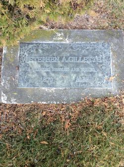
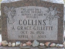
Stephen Andrew Gillette
| Birth | : | 24 Jan 1879 Princeton, Mercer County, Missouri, USA |
| Death | : | 12 Jun 1955 Post Falls, Kootenai County, Idaho, USA |
| Burial | : | Mountain View Cemetery, Loomis, Okanogan County, USA |
| Coordinate | : | 48.8152700, -119.6100100 |
| Description | : | Idaho, Death Index, 1890-1962 Name:Steven Andrew Gillette Birth Place:Missouri Birth Date:24 Jan 1879 Death Place:Post Falls, Kootenai, Idaho, USA Death Date:12 Jun 1955 Father:Andrew J. Jackson (Andrew Jackson Gillette) (1828-1916) Father Birth Place:New York Mother:Hannah Jan Cheney (Hannah Jane Cheney) (1835-1901) Mother Birth Place:New York Certificate Year:1955 Certificate Number:002151 |
frequently asked questions (FAQ):
-
Where is Stephen Andrew Gillette's memorial?
Stephen Andrew Gillette's memorial is located at: Mountain View Cemetery, Loomis, Okanogan County, USA.
-
When did Stephen Andrew Gillette death?
Stephen Andrew Gillette death on 12 Jun 1955 in Post Falls, Kootenai County, Idaho, USA
-
Where are the coordinates of the Stephen Andrew Gillette's memorial?
Latitude: 48.8152700
Longitude: -119.6100100
Family Members:
Parent

Spouse
Siblings
Children
Flowers:


Nearby Cemetories:
1. Mountain View Cemetery
Loomis, Okanogan County, USA
Coordinate: 48.8152700, -119.6100100
2. Little Chopaka Cemetery
Okanogan County, USA
Coordinate: 48.8272200, -119.6430600
3. Golden Cemetery
Okanogan County, USA
Coordinate: 48.9014015, -119.5203018
4. Old Oroville Cemetery
Okanogan County, USA
Coordinate: 48.8913360, -119.4456230
5. Mountain View Memorial Cemetery
Ellisforde, Okanogan County, USA
Coordinate: 48.8328300, -119.4011300
6. Ellisforde Mission Cemetery
Ellisforde, Okanogan County, USA
Coordinate: 48.7908300, -119.3972300
7. Tonasket Cemetery
Tonasket, Okanogan County, USA
Coordinate: 48.7284400, -119.4328200
8. Old Riverview Cemetery
Oroville, Okanogan County, USA
Coordinate: 48.9177800, -119.4466700
9. Oroville Riverview Cemetery
Oroville, Okanogan County, USA
Coordinate: 48.9202700, -119.4458500
10. Pine Creek Cemetery
Tonasket, Okanogan County, USA
Coordinate: 48.6330560, -119.6502780
11. South Pine Creek Cemetery
Riverside, Okanogan County, USA
Coordinate: 48.5925900, -119.5663400
12. Osoyoos Lakeview Cemetery
Osoyoos, Okanagan-Similkameen Regional District, Canada
Coordinate: 49.0638600, -119.5185500
13. Phillip Raux Gravesite
Riverside, Okanogan County, USA
Coordinate: 48.6271800, -119.3308500
14. Anglin Cemetery
Okanogan County, USA
Coordinate: 48.6627700, -119.2783400
15. Cook Place Cemetery
Tonasket, Okanogan County, USA
Coordinate: 48.6083330, -119.3544440
16. Cook Family Cemetery
Carlton, Okanogan County, USA
Coordinate: 48.6083300, -119.3544400
17. Immanuel Lutheran Cemetery
Havillah, Okanogan County, USA
Coordinate: 48.8305500, -119.2033500
18. Conconully Cemetery
Conconully, Okanogan County, USA
Coordinate: 48.5441600, -119.7400100
19. Molson Cemetery
Molson, Okanogan County, USA
Coordinate: 48.9657000, -119.2105000
20. Valley Congregational Church Memorial Rose Garden
Oliver, Okanagan-Similkameen Regional District, Canada
Coordinate: 49.1169070, -119.5575920
21. Kipling Cemetery
Okanogan County, USA
Coordinate: 48.9080500, -119.1652900
22. Ruby Cemetery
Okanogan County, USA
Coordinate: 48.5085983, -119.7221985
23. Sidley-Lawless Cemetery
Sidley, Kootenay Boundary Regional District, Canada
Coordinate: 49.0153330, -119.2234330
24. Riverside Cemetery
Riverside, Okanogan County, USA
Coordinate: 48.4944400, -119.5022200