
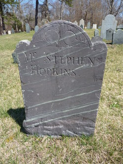

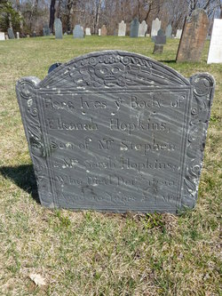
Stephen Hopkins
| Birth | : | 15 Jul 1670 Eastham, Barnstable County, Massachusetts, USA |
| Death | : | 9 Apr 1733 Harwich, Barnstable County, Massachusetts, USA |
| Burial | : | Riverside Cemetery, Fort Fairfield, Aroostook County, USA |
| Coordinate | : | 46.7750015, -67.8060989 |
| Inscription | : | father of Elkanah |
| Description | : | The Mayo survey shows 3 Hopkins buried next to each other. They are Elkanah 1720 age 20 Jonathan 1716 age 24th year Stephen 1733 age 63d year - no headstone for Stephen when Mayo did the survey in the late 1800's. Mayo says Stephen 1733 married Sarah, daughter of Capt. Thomas Howes Jr. Clearly Stephen 1733 is the father of Elkanah and Jonathan Mayo gives the line of... Read More |
frequently asked questions (FAQ):
-
Where is Stephen Hopkins's memorial?
Stephen Hopkins's memorial is located at: Riverside Cemetery, Fort Fairfield, Aroostook County, USA.
-
When did Stephen Hopkins death?
Stephen Hopkins death on 9 Apr 1733 in Harwich, Barnstable County, Massachusetts, USA
-
Where are the coordinates of the Stephen Hopkins's memorial?
Latitude: 46.7750015
Longitude: -67.8060989
Family Members:
Parent
Siblings

Children
Flowers:


Nearby Cemetories:
1. Riverside Cemetery
Fort Fairfield, Aroostook County, USA
Coordinate: 46.7750015, -67.8060989
2. Saint Denis Catholic Cemetery
Fort Fairfield, Aroostook County, USA
Coordinate: 46.7773440, -67.8355030
3. Harvey Hill Cemetery
McShea, Aroostook County, USA
Coordinate: 46.7567099, -67.8652997
4. Union Cemetery
Fort Fairfield, Aroostook County, USA
Coordinate: 46.7566150, -67.8655240
5. Our Lady of Mercy Cemetery
Aroostook, Victoria County, Canada
Coordinate: 46.7977210, -67.7263700
6. Haines Maple Grove Cemetery
Fort Fairfield, Aroostook County, USA
Coordinate: 46.7233160, -67.8699040
7. Saint Ann Parish - Tobique First Nation Cemetery
Tobique, Victoria County, Canada
Coordinate: 46.7692510, -67.7055300
8. St. John The Evangelist Anglican Cemetery
Four Falls, Victoria County, Canada
Coordinate: 46.8278880, -67.7366425
9. Saint Mary of the Angels
Perth-Andover, Victoria County, Canada
Coordinate: 46.7607665, -67.7018074
10. Presbyterian Rural Cemetery
Perth-Andover, Victoria County, Canada
Coordinate: 46.7600894, -67.7013150
11. Wark Cemetery
Perth-Andover, Victoria County, Canada
Coordinate: 46.7286569, -67.7205736
12. Trinity Anglican Church Cemetery
Perth-Andover, Victoria County, Canada
Coordinate: 46.7571174, -67.6990229
13. Hillcrest Cemetery
Perth-Andover, Victoria County, Canada
Coordinate: 46.7431800, -67.7044100
14. Old Methodist Church Cemetery
Perth-Andover, Victoria County, Canada
Coordinate: 46.7506500, -67.6967900
15. Perth-Andover Baptist Church Cemetery
Perth-Andover, Victoria County, Canada
Coordinate: 46.7478522, -67.6969303
16. Larlee Creek Cemetery
Perth-Andover, Victoria County, Canada
Coordinate: 46.7147700, -67.7183500
17. Greenridge Cemetery
Caribou, Aroostook County, USA
Coordinate: 46.7923622, -67.9321976
18. Old Langley Cemetery
California Settlement, Victoria County, Canada
Coordinate: 46.8671210, -67.7631380
19. Knight Cemetery
Fort Fairfield, Aroostook County, USA
Coordinate: 46.6876150, -67.8778140
20. Kenneson Cemetery
Limestone, Aroostook County, USA
Coordinate: 46.8797900, -67.8047921
21. Bean Family Cemetery
Aroostook County, USA
Coordinate: 46.7396440, -67.9542600
22. Pine Tree Cemetery
Easton, Aroostook County, USA
Coordinate: 46.6774640, -67.8727940
23. Currie Cemetery
North Tilley, Victoria County, Canada
Coordinate: 46.8491850, -67.6886480
24. Beaconsfield Baptist Church Cemetery
Beaconsfield, Victoria County, Canada
Coordinate: 46.6640360, -67.7803850