
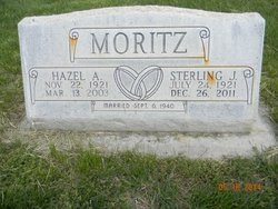
Sterling John Moritz
| Birth | : | 24 Jul 1921 Frontier County, Nebraska, USA |
| Death | : | 26 Dec 2011 Elwood, Gosper County, Nebraska, USA |
| Burial | : | Greenwood Cemetery, Lexington, Dawson County, USA |
| Coordinate | : | 40.7956467, -99.7286682 |
| Plot | : | DIV. A, BLOCK 57, LOT 2, SPACE 3. |
| Description | : | Sterling John Moritz, 90, of Lexington, Nebraska, passed away Monday, December 26, 2011, at the Elwood Care Center in Elwood. Sterling was born July 24, 1921 on a farm 13 miles south of Eustis, Nebraska to John Fredrick and Lucy (Puls) Moritz. Sterling attended country school in Frontier County. He was united in marriage to Hazel A. Hess on September 6, 1940 at Elwood, Nebraska. Two sons were blessed to this marriage; Sterling, Jr. (Joe) and Gary. Sterling farmed for several years, worked for the Rosenberg Company and trucked for R.T. Hansen. It was during his years with R.T. Hansen that... Read More |
frequently asked questions (FAQ):
-
Where is Sterling John Moritz's memorial?
Sterling John Moritz's memorial is located at: Greenwood Cemetery, Lexington, Dawson County, USA.
-
When did Sterling John Moritz death?
Sterling John Moritz death on 26 Dec 2011 in Elwood, Gosper County, Nebraska, USA
-
Where are the coordinates of the Sterling John Moritz's memorial?
Latitude: 40.7956467
Longitude: -99.7286682
Family Members:
Parent

Spouse

Siblings
Flowers:


Nearby Cemetories:
1. First United Methodist Church Columbarium
Lexington, Dawson County, USA
Coordinate: 40.7810000, -99.7397000
2. Saint Anns Cemetery
Lexington, Dawson County, USA
Coordinate: 40.7789001, -99.7114029
3. Evergreen Cemetery
Lexington, Dawson County, USA
Coordinate: 40.7639008, -99.6791992
4. Mount Hope Cemetery
Dawson County, USA
Coordinate: 40.8293991, -99.6733017
5. Hewitt Cemetery
Lexington, Dawson County, USA
Coordinate: 40.8588982, -99.7769012
6. Buffalo Grove Presbyterian Church Cemetery
Buffalo, Dawson County, USA
Coordinate: 40.8721000, -99.8270000
7. Hillside Cemetery
Dawson County, USA
Coordinate: 40.8946991, -99.7869034
8. Grace Cemetery
Cozad, Dawson County, USA
Coordinate: 40.8602982, -99.8644028
9. Robb Cemetery
Smithfield, Gosper County, USA
Coordinate: 40.6710691, -99.6996001
10. Saint Johns Lutheran Cemetery
Lexington, Dawson County, USA
Coordinate: 40.9019012, -99.8458023
11. Plum Creek Massacre Cemetery
Phelps County, USA
Coordinate: 40.6726840, -99.6058220
12. Overton Cemetery
Overton, Dawson County, USA
Coordinate: 40.7317009, -99.5222015
13. Cozad Cemetery
Cozad, Dawson County, USA
Coordinate: 40.8605995, -99.9475021
14. Quakerville Cemetery
Gosper County, USA
Coordinate: 40.6189003, -99.8097000
15. Cottonwood Cemetery
Dawson County, USA
Coordinate: 40.9322014, -99.9197006
16. Saint Patricks Cemetery
Eddyville, Dawson County, USA
Coordinate: 40.9747009, -99.6093979
17. Adullam Cemetery
Bertrand, Phelps County, USA
Coordinate: 40.6265000, -99.5856000
18. Fairview Cemetery
Dawson County, USA
Coordinate: 40.7719002, -99.9955978
19. Jewell Cemetery
Sumner, Dawson County, USA
Coordinate: 40.9599991, -99.5646973
20. Rose Hill Cemetery
Dawson County, USA
Coordinate: 40.9888992, -99.8442001
21. Elwood Cemetery
Elwood, Gosper County, USA
Coordinate: 40.5999300, -99.8397300
22. Rhinehart Cemetery
Cozad, Dawson County, USA
Coordinate: 40.9599000, -99.9105000
23. Buffalo First Lutheran Cemetery Old
Buffalo, Dawson County, USA
Coordinate: 41.0100000, -99.8152000
24. Buffalo First Lutheran Cemetery New
Buffalo, Dawson County, USA
Coordinate: 41.0127000, -99.8150000