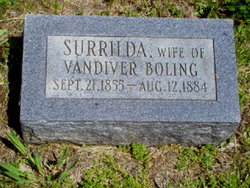
Surrilda Payne Boling
| Birth | : | 27 Aug 1855 Indiana, USA |
| Death | : | 13 Aug 1884 Indiana, USA |
| Burial | : | Rock Lake Cemetery, Lake Mills, Jefferson County, USA |
| Coordinate | : | 43.0896988, -88.9131012 |
| Description | : | Age 28 yrs, 10 mths, 17 days. Wife of Vandiver Boling, married 9/3/1874. Daughter of Thomas Payne and Chloe Williams Payne. |
frequently asked questions (FAQ):
-
Where is Surrilda Payne Boling's memorial?
Surrilda Payne Boling's memorial is located at: Rock Lake Cemetery, Lake Mills, Jefferson County, USA.
-
When did Surrilda Payne Boling death?
Surrilda Payne Boling death on 13 Aug 1884 in Indiana, USA
-
Where are the coordinates of the Surrilda Payne Boling's memorial?
Latitude: 43.0896988
Longitude: -88.9131012
Family Members:
Parent
Spouse
Siblings
Children
Flowers:
Nearby Cemetories:
1. Rock Lake Cemetery
Lake Mills, Jefferson County, USA
Coordinate: 43.0896988, -88.9131012
2. Saint Johns Evangelical Lutheran Cemetery
Lake Mills, Jefferson County, USA
Coordinate: 43.1074982, -88.9441986
3. Saint Pauls Evangelical Lutheran Cemetery
Lake Mills, Jefferson County, USA
Coordinate: 43.0591800, -88.9218900
4. Aztalan Cemetery
Milford, Jefferson County, USA
Coordinate: 43.0839005, -88.8630981
5. Neville Cemetery
Waterloo, Jefferson County, USA
Coordinate: 43.1289270, -88.9312040
6. Salem Evangelical United Brethren Cemetery
Milford, Jefferson County, USA
Coordinate: 43.0972710, -88.8208313
7. Saint Wenceslaus Cemetery
Waterloo, Jefferson County, USA
Coordinate: 43.1611000, -88.9218000
8. Kroghville Cemetery
Kroghville, Jefferson County, USA
Coordinate: 43.0663800, -89.0069400
9. Gericke Cemetery
Kroghville, Jefferson County, USA
Coordinate: 43.0674930, -89.0115740
10. South Road Cemetery
Waterloo, Jefferson County, USA
Coordinate: 43.1467018, -88.9914017
11. Island Cemetery
Waterloo, Jefferson County, USA
Coordinate: 43.1725006, -88.9207993
12. Edwards Family Plot
Waterloo, Jefferson County, USA
Coordinate: 43.1745900, -88.8985800
13. German Methodist Cemetery
Milford, Jefferson County, USA
Coordinate: 43.1221619, -88.8025208
14. North Oakland Cemetery
Oakland, Jefferson County, USA
Coordinate: 43.0018997, -88.9088974
15. Jordan Cemetery
Waterloo, Jefferson County, USA
Coordinate: 43.1699982, -88.9619980
16. Mamre Moravian Cemetery
Milford, Jefferson County, USA
Coordinate: 43.1717030, -88.8433030
17. Saint Marys Cemetery
Johnson Creek, Jefferson County, USA
Coordinate: 43.0685997, -88.7814026
18. Oak Hill Cemetery
Waterloo, Jefferson County, USA
Coordinate: 43.1836040, -88.9748170
19. Evergreen Cemetery
Johnson Creek, Jefferson County, USA
Coordinate: 43.0764008, -88.7703018
20. City of Waterloo Cemetery
Waterloo, Jefferson County, USA
Coordinate: 43.1801140, -88.9900520
21. Hubbleton Cemetery
Hubbleton, Jefferson County, USA
Coordinate: 43.1952600, -88.8939700
22. Lake Ripley Cemetery
Cambridge, Jefferson County, USA
Coordinate: 43.0041809, -89.0011673
23. Saint Josephs Catholic Cemetery
Waterloo, Jefferson County, USA
Coordinate: 43.1800600, -88.9994720
24. Greenwood Cemetery
Jefferson, Jefferson County, USA
Coordinate: 43.0116997, -88.8041992


