
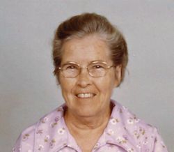
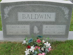
Swana Lee Baldwin
| Birth | : | 2 Jan 1907 Randolph County, North Carolina, USA |
| Death | : | 21 Jan 2002 Franklinville, Randolph County, North Carolina, USA |
| Burial | : | Edge Hill Cemetery, Charles Town, Jefferson County, USA |
| Coordinate | : | 39.2882800, -77.8510500 |
| Description | : | FRANKLINVILLE - Swana Lee Baldwin, 95, formerly of Tom Brown Road, died Monday, Jan. 21, 2002, at SunBridge Care and Rehabilitation. Funeral service will be 2 p.m. Wednesday at Bethany United Methodist Church, with the Rev. R. Curran Welch officiating. Burial will be in the church cemetery. She was a native of Randolph County and a former teacher and librarian with the Randolph County Schools system. Surviving is sister, Florence Williams of Franklinville. The family will be at Pugh Funeral Home, Randleman, 7-9 p.m. Tuesday. Memorials may be made to Bethany United Methodist Church, 3650 Bethany Church Road, Franklinville, N.C. 27248. |
frequently asked questions (FAQ):
-
Where is Swana Lee Baldwin's memorial?
Swana Lee Baldwin's memorial is located at: Edge Hill Cemetery, Charles Town, Jefferson County, USA.
-
When did Swana Lee Baldwin death?
Swana Lee Baldwin death on 21 Jan 2002 in Franklinville, Randolph County, North Carolina, USA
-
Where are the coordinates of the Swana Lee Baldwin's memorial?
Latitude: 39.2882800
Longitude: -77.8510500
Family Members:
Parent

Siblings

Flowers:


Nearby Cemetories:
1. Edge Hill Cemetery
Charles Town, Jefferson County, USA
Coordinate: 39.2882800, -77.8510500
2. Zion Episcopal Churchyard
Charles Town, Jefferson County, USA
Coordinate: 39.2890400, -77.8566600
3. Robert Rutherford Gravesite
Charles Town, Jefferson County, USA
Coordinate: 39.2938499, -77.8452835
4. Asbury United Methodist Church Cemetery
Charles Town, Jefferson County, USA
Coordinate: 39.2905350, -77.8620834
5. Fairview Cemetery
Gibsontown, Jefferson County, USA
Coordinate: 39.2695650, -77.8756210
6. Peter K. Johnson Farm Graveyard
Charles Town, Jefferson County, USA
Coordinate: 39.2617536, -77.9051369
7. Washington Burial Ground
Charles Town, Jefferson County, USA
Coordinate: 39.3020379, -77.9163828
8. Quaker Cemetery
Charles Town, Jefferson County, USA
Coordinate: 39.2442586, -77.9017906
9. Saint Andrews on the Mount Episcopal Churchyard
Mountain Mission, Jefferson County, USA
Coordinate: 39.2459970, -77.7967710
10. Murrill Hill United Methodist Church Cemetery
Mountain Mission, Jefferson County, USA
Coordinate: 39.2472900, -77.7950300
11. Johnsontown Cemetery
Johnsontown, Jefferson County, USA
Coordinate: 39.3404200, -77.8910700
12. Payne's Hill Cemetery
Halltown, Jefferson County, USA
Coordinate: 39.3190730, -77.7810570
13. Poor Farm Cemetery
Kearneysville, Jefferson County, USA
Coordinate: 39.3345590, -77.9094350
14. Allstadt Graveyard
Halltown, Jefferson County, USA
Coordinate: 39.3145270, -77.7732030
15. Chestnut Hill United Methodist Church Cemetery
Harpers Ferry, Jefferson County, USA
Coordinate: 39.2714800, -77.7681500
16. Moler Graveyard
Halltown, Jefferson County, USA
Coordinate: 39.3188400, -77.7739900
17. Kabletown Churchyard
Kabletown, Jefferson County, USA
Coordinate: 39.2215881, -77.8597183
18. Lock Family Cemetery
Wheatland, Jefferson County, USA
Coordinate: 39.2273780, -77.8872300
19. Darke-Engle-Ronemous Cemetery
Shenandoah Junction, Jefferson County, USA
Coordinate: 39.3544250, -77.8314400
20. Grove Cemetery
Keyes Ferry Acres, Jefferson County, USA
Coordinate: 39.2741014, -77.7644080
21. Mount Zion AME Church Cemetery
Reedson, Jefferson County, USA
Coordinate: 39.3492120, -77.8001050
22. New Hopewell Cemetery
Kearneysville, Jefferson County, USA
Coordinate: 39.3520000, -77.8990000
23. Willow View Blackford Slave Cemetery
Kearneysville, Jefferson County, USA
Coordinate: 39.3607854, -77.8725668
24. Silver Grove Cemetery
Harpers Ferry, Jefferson County, USA
Coordinate: 39.2962044, -77.7552686