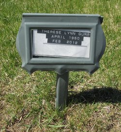
Therese Lynn Bernard Gurr
| Birth | : | 2 Apr 1960 Sioux City, Woodbury County, Iowa, USA |
| Death | : | 18 Feb 2012 Fernie, East Kootenay Regional District, British Columbia, Canada |
| Burial | : | Rivercrest Cemetery, Sparwood, East Kootenay Regional District, Canada |
| Coordinate | : | 49.7617300, -114.8862200 |
| Description | : | Therese Lynn Gurr (nee Bernard) of Sparwood, BC, passed away, at the age of 51, in the Elk Valley Regional Hospital in Fernie on February 18, 2012 surrounded by her loving family. Therese was born on April 2, 1960, in Sioux City, Iowa to Wilfred and Marguerite Bernard. She was the 11th of 12 children in the family. She was always proud of her Iowa farm-girl heritage. In 1982-83, Therese served as a missionary for the Church of Jesus Christ of Latter-Day Saints in the Canada Calgary Mission. After her mission, she married Michael Gurr in the Salt Lake... Read More |
frequently asked questions (FAQ):
-
Where is Therese Lynn Bernard Gurr's memorial?
Therese Lynn Bernard Gurr's memorial is located at: Rivercrest Cemetery, Sparwood, East Kootenay Regional District, Canada.
-
When did Therese Lynn Bernard Gurr death?
Therese Lynn Bernard Gurr death on 18 Feb 2012 in Fernie, East Kootenay Regional District, British Columbia, Canada
-
Where are the coordinates of the Therese Lynn Bernard Gurr's memorial?
Latitude: 49.7617300
Longitude: -114.8862200
Family Members:
Parent
Siblings
Flowers:
Nearby Cemetories:
1. Rivercrest Cemetery
Sparwood, East Kootenay Regional District, Canada
Coordinate: 49.7617300, -114.8862200
2. Elk Valley Cemetery
Sparwood, East Kootenay Regional District, Canada
Coordinate: 49.7403800, -114.8685100
3. Hosmer Cemetery
Hosmer, East Kootenay Regional District, Canada
Coordinate: 49.5863580, -114.9565980
4. Corbin Cemetery
Corbin, East Kootenay Regional District, Canada
Coordinate: 49.5217700, -114.6785500
5. Coleman Catholic Cemetery
Crowsnest Pass, Canmore Census Division, Canada
Coordinate: 49.6396500, -114.5012710
6. Coleman Union Cemetery
Crowsnest Pass, Canmore Census Division, Canada
Coordinate: 49.6402600, -114.4999000
7. East Fernie Cemetery
Fernie, East Kootenay Regional District, Canada
Coordinate: 49.5018590, -115.0566640
8. Fernie Cemetery
Fernie, East Kootenay Regional District, Canada
Coordinate: 49.5002240, -115.0579050
9. Saint Margaret's Cemetery
Fernie, East Kootenay Regional District, Canada
Coordinate: 49.4989900, -115.0550900
10. Mountview Cemetery
Elkford, East Kootenay Regional District, Canada
Coordinate: 50.0583600, -114.9222300
11. New Blairmore Union Cemetery
Crowsnest Pass, Canmore Census Division, Canada
Coordinate: 49.6126700, -114.4387650
12. Saint Annes Roman Catholic Cemetery
Crowsnest Pass, Canmore Census Division, Canada
Coordinate: 49.6119900, -114.4369000
13. Old Blairmore Union Cemetery
Crowsnest Pass, Canmore Census Division, Canada
Coordinate: 49.6117400, -114.4343000
14. Lille Cemetery
Crowsnest Pass, Canmore Census Division, Canada
Coordinate: 49.6459650, -114.3928460
15. Frank Slide Memorial Cemetery
Crowsnest Pass, Canmore Census Division, Canada
Coordinate: 49.5936535, -114.3997562
16. The Frank Slide
Crowsnest Pass, Canmore Census Division, Canada
Coordinate: 49.5924431, -114.3940019
17. Frank Cemetery
Crowsnest Pass, Canmore Census Division, Canada
Coordinate: 49.5970300, -114.3860400
18. Saint Cyril's Catholic Cemetery
Crowsnest Pass, Canmore Census Division, Canada
Coordinate: 49.5873230, -114.3788040
19. Hillcrest Cemetery
Crowsnest Pass, Canmore Census Division, Canada
Coordinate: 49.5757290, -114.3799920
20. Bellevue Union Cemetery
Crowsnest Pass, Canmore Census Division, Canada
Coordinate: 49.5804710, -114.3643875
21. Morrissey Cemetery
Morrissey, East Kootenay Regional District, Canada
Coordinate: 49.3751030, -114.9941990
22. Hannah Robinson Gravesite
Morrissey, East Kootenay Regional District, Canada
Coordinate: 49.3725000, -114.9913800
23. Passburg Cemetery
Crowsnest Pass, Canmore Census Division, Canada
Coordinate: 49.5631230, -114.3387240
24. Livingstone Hutterite Colony Cemetery
Lundbreck, Claresholm Census Division, Canada
Coordinate: 49.6498659, -114.1594770


