
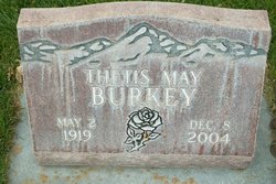
Thetis May Bartlett Burkey
| Birth | : | 2 May 1919 Sterling, Logan County, Colorado, USA |
| Death | : | 8 Dec 2004 Colorado Springs, El Paso County, Colorado, USA |
| Burial | : | Terrace Grove Cemetery, Belen, Valencia County, USA |
| Coordinate | : | 34.6702995, -106.7844009 |
| Description | : | Thetis May Burkey, 85, of Sterling, died Dec. 8, 2004, in Colorado Springs. Funeral services are Dec. 13 at 1 p.m. at Church of Jesus Christ of Latter-Day Saints, with Bishop G. Bill Sanchez officiating. Burial will follow at Riverside Cemetery. She was born May 2, 1919, in Sterling, to Carl and Myrtle (James) Bartlett. She was a member of the Church of Jesus Christ of Latter-Day Saints. |
frequently asked questions (FAQ):
-
Where is Thetis May Bartlett Burkey's memorial?
Thetis May Bartlett Burkey's memorial is located at: Terrace Grove Cemetery, Belen, Valencia County, USA.
-
When did Thetis May Bartlett Burkey death?
Thetis May Bartlett Burkey death on 8 Dec 2004 in Colorado Springs, El Paso County, Colorado, USA
-
Where are the coordinates of the Thetis May Bartlett Burkey's memorial?
Latitude: 34.6702995
Longitude: -106.7844009
Family Members:
Spouse
Flowers:


Nearby Cemetories:
1. Terrace Grove Cemetery
Belen, Valencia County, USA
Coordinate: 34.6702995, -106.7844009
2. Our Lady of Belen Memorial Gardens
Belen, Valencia County, USA
Coordinate: 34.6613998, -106.7835999
3. Saint Philip Columbarium
Los Lunas, Valencia County, USA
Coordinate: 34.6508530, -106.7329040
4. First United Methodist Church Columbarium
Belen, Valencia County, USA
Coordinate: 34.6556000, -106.7259000
5. Belen Mennonite Church Cemetery
Belen, Valencia County, USA
Coordinate: 34.6212800, -106.7081300
6. El Cemeterio de Los Ricos
Tome, Valencia County, USA
Coordinate: 34.7388790, -106.7325590
7. Tome Cemetery
Tome, Valencia County, USA
Coordinate: 34.7243996, -106.7071991
8. Immaculate Conception Church Cemetery
Tome, Valencia County, USA
Coordinate: 34.7417270, -106.7299250
9. Casa de Coloradas Cemetery
Casa Colorada, Valencia County, USA
Coordinate: 34.5770000, -106.7484000
10. Cristo Rey Cemetery
Bosque, Valencia County, USA
Coordinate: 34.5674530, -106.7999090
11. Seventh Day Adventist Cemetery
Los Lunas, Valencia County, USA
Coordinate: 34.7774840, -106.7105250
12. San Clemente Cemetery
Los Lunas, Valencia County, USA
Coordinate: 34.8059550, -106.7353750
13. San Antonio Cemetery
Sabinal, Socorro County, USA
Coordinate: 34.5287800, -106.7965200
14. San Clemente Cemetery
Los Lunas, Valencia County, USA
Coordinate: 34.8105000, -106.7424000
15. El Camposanto de la Liverta
Los Lunas, Valencia County, USA
Coordinate: 34.7905998, -106.6746979
16. Los Lunas Hospital And Training School Cemetery
Los Lunas, Valencia County, USA
Coordinate: 34.8198060, -106.7427210
17. San Antonio de los Lentes Cemetery
Los Lunas, Valencia County, USA
Coordinate: 34.8202200, -106.7412700
18. Los Lentes Cemetery
Los Lentes, Valencia County, USA
Coordinate: 34.8203011, -106.7406006
19. Sangre de Cristo Cemetery
Los Lunas, Valencia County, USA
Coordinate: 34.8100160, -106.6997550
20. Veguita Catholic Cemetery
Veguita, Socorro County, USA
Coordinate: 34.5126900, -106.7675700
21. Veguita Memorial Cemetery
Veguita, Socorro County, USA
Coordinate: 34.5124700, -106.7656600
22. Our Lady of Guadalupe Catholic Cemetery
Valencia, Valencia County, USA
Coordinate: 34.8136400, -106.6685300
23. Peralta and Valencia Cemetery
Peralta, Valencia County, USA
Coordinate: 34.8139000, -106.6678009
24. Chihuahua Bible Chapel Cemetery
Veguita, Socorro County, USA
Coordinate: 34.4903100, -106.7644900