
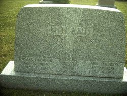
Thomas Franklin Noland
| Birth | : | 22 Jan 1869 West Carlisle, Coshocton County, Ohio, USA |
| Death | : | 16 Jul 1945 Licking County, Ohio, USA |
| Burial | : | Noupoort Garden Of Remembrance, Noupoort, Pixley ka Seme District Municipality, South Africa |
| Description | : | In 1880 he and his parents and five siblings lived on a farm in Pike Township, Coshocton County, OH. In 1910 he and his wife, their two children, and a hired man, 23-year-old Ralph Priest, lived on a farm they owned, mortgage free, in Perry Township, Licking County, OH. In 1920 he and Flora, their son, and her mother lived there. In 1930 he and his wife and a hired hand, 47-year-old Walter L Priest, lived there. They did not have a radio. In 1940 just he and Flora lived there. Their home was valued at... Read More |
frequently asked questions (FAQ):
-
Where is Thomas Franklin Noland's memorial?
Thomas Franklin Noland's memorial is located at: Noupoort Garden Of Remembrance, Noupoort, Pixley ka Seme District Municipality, South Africa.
-
When did Thomas Franklin Noland death?
Thomas Franklin Noland death on 16 Jul 1945 in Licking County, Ohio, USA
Family Members:
Parent
Spouse

Siblings
Children
Flowers:


Nearby Cemetories:
1. Bongweni Burial Ground
Colesberg, Pixley ka Seme District Municipality, South Africa
Coordinate: -29.0677570, 23.6810183
2. Colesberg Boer Military Cemetery
Colesberg, Pixley ka Seme District Municipality, South Africa
Coordinate: -30.9962000, 23.7926700
3. Colesberg British Military Cemetery
Colesberg, Pixley ka Seme District Municipality, South Africa
Coordinate: -29.4018263, 22.1052065
4. Colesberg Cemetery
Colesberg, Pixley ka Seme District Municipality, South Africa
Coordinate: -29.4035941, 22.1143920
5. Colesberg Jewish Cemetery
Colesberg, Pixley ka Seme District Municipality, South Africa
Coordinate: -29.0280487, 24.2382434
6. Colesberg Main Cemetery
Colesberg, Pixley ka Seme District Municipality, South Africa
Coordinate: -29.0298318, 24.2359814
7. Kuyasa Cemetery
Colesberg, Pixley ka Seme District Municipality, South Africa
Coordinate: -29.6790500, 24.2046170
8. Hopetown Cemetery
Hopetown, Pixley ka Seme District Municipality, South Africa
Coordinate: -29.0552200, 23.7780700
9. Liebenbergspan Farm Burial Ground
Hopetown, Pixley ka Seme District Municipality, South Africa
Coordinate: -29.0661670, 23.7583500
10. Pioneers Cemetery
Hopetown, Pixley ka Seme District Municipality, South Africa
Coordinate: -29.0547170, 23.7808670
11. Steynville Cemetery
Hopetown, Pixley ka Seme District Municipality, South Africa
Coordinate: -29.3187564, 22.8430914
12. Van Wyksvle Cemetery
Van Wyksvlei, Pixley ka Seme District Municipality, South Africa
Coordinate: -29.3319965, 22.8440114
13. Bucklands Cemetery
Bucklands, Pixley ka Seme District Municipality, South Africa
Coordinate: -29.0677570, 23.6810183
14. Deelfontein Cemetery
Deelfontein, Pixley ka Seme District Municipality, South Africa
Coordinate: -30.9962000, 23.7926700
15. Marydale Cemetery
Marydale, Pixley ka Seme District Municipality, South Africa
Coordinate: -29.4018263, 22.1052065
16. Marydale East Cemetery
Marydale, Pixley ka Seme District Municipality, South Africa
Coordinate: -29.4035941, 22.1143920
17. NG Kerk - Plooysburg Kerkhof
Plooysburg, Pixley ka Seme District Municipality, South Africa
Coordinate: -29.0280487, 24.2382434
18. Plooysburg Cemetery
Plooysburg, Pixley ka Seme District Municipality, South Africa
Coordinate: -29.0298318, 24.2359814
19. Doornbult Concentration Camp Cemetery
Pixley ka Seme District Municipality, South Africa
Coordinate: -29.6790500, 24.2046170
20. Douglas Anglican Cemetery
Douglas, Pixley ka Seme District Municipality, South Africa
Coordinate: -29.0552200, 23.7780700
21. Douglas Main Cemetery
Douglas, Pixley ka Seme District Municipality, South Africa
Coordinate: -29.0661670, 23.7583500
22. Reverend Isaac Hughes Grave Site
Douglas, Pixley ka Seme District Municipality, South Africa
Coordinate: -29.0547170, 23.7808670
23. Niekerkshoop North Cemetery
Niekerkshoop, Pixley ka Seme District Municipality, South Africa
Coordinate: -29.3187564, 22.8430914
24. Niekerkshoop South Cemetery
Niekerkshoop, Pixley ka Seme District Municipality, South Africa
Coordinate: -29.3319965, 22.8440114