
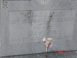
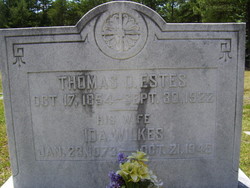
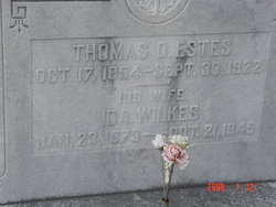
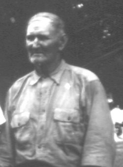
Thomas Oliver Estes Sr.
| Birth | : | 17 Oct 1854 South Carolina, USA |
| Death | : | 30 Sep 1922 USA |
| Burial | : | McLerran Cemetery, Moss, Clay County, USA |
| Coordinate | : | 36.5790000, -85.5973000 |
| Description | : | Mr. Thos. O. Estes, of the Leeds neighborhood, one of Chester county's best known and most successful farmers, died Friday night at the Chester hospital, following an operation, and was laid to rest yesterday in Calvary Baptist church graveyard, the funeral services being conducted by the Rev. J. H. Yarborough. Mr. Estes was a native of the western section of the county and was sixty-seven years of age. He was a lifelong member of Calvary Baptist church, and at the time of his death was a deacon. He was active in the affairs of his denomination, and was a useful... Read More |
frequently asked questions (FAQ):
-
Where is Thomas Oliver Estes Sr.'s memorial?
Thomas Oliver Estes Sr.'s memorial is located at: McLerran Cemetery, Moss, Clay County, USA.
-
When did Thomas Oliver Estes Sr. death?
Thomas Oliver Estes Sr. death on 30 Sep 1922 in USA
-
Where are the coordinates of the Thomas Oliver Estes Sr.'s memorial?
Latitude: 36.5790000
Longitude: -85.5973000
Family Members:
Parent
Spouse
Siblings

Children


Nearby Cemetories:
1. McLerran Cemetery
Moss, Clay County, USA
Coordinate: 36.5790000, -85.5973000
2. Strong Family Cemetery
Clay County, USA
Coordinate: 36.5690700, -85.6042600
3. Spear Family Cemetery
Moss, Clay County, USA
Coordinate: 36.5933200, -85.5876500
4. Meadows Cemetery
Clay County, USA
Coordinate: 36.5946999, -85.5875015
5. Macedonia Cemetery
Moss, Clay County, USA
Coordinate: 36.5643997, -85.6110992
6. Odle Cemetery
Clay County, USA
Coordinate: 36.5966988, -85.6085968
7. Moss Cemetery
Moss, Clay County, USA
Coordinate: 36.5911210, -85.6214460
8. Kendall Cemetery
Moss, Clay County, USA
Coordinate: 36.5672540, -85.6362650
9. New Hope Cemetery
Clay County, USA
Coordinate: 36.6021996, -85.5653000
10. Walker Reecer Cemetery
Celina, Clay County, USA
Coordinate: 36.5746290, -85.5480270
11. Eads-Denton Cemetery
Pine Hill, Clay County, USA
Coordinate: 36.5644207, -85.6503187
12. Moore Cemetery
Moss, Clay County, USA
Coordinate: 36.6113400, -85.6374980
13. Liberty Church Cemetery
Boles, Clay County, USA
Coordinate: 36.6010850, -85.6496830
14. Smith Cemetery
Pine Hill, Clay County, USA
Coordinate: 36.5714930, -85.6568170
15. Dalton Cemetery
Arcott, Clay County, USA
Coordinate: 36.5429540, -85.5546170
16. Willhoite-Curtis Cemetery
Tompkinsville, Monroe County, USA
Coordinate: 36.6182208, -85.6442948
17. Freedom Cemetery #2
Tompkinsville, Monroe County, USA
Coordinate: 36.6284060, -85.6289940
18. Plumlee Cemetery
Celina, Clay County, USA
Coordinate: 36.5694280, -85.5282830
19. Archibald Plumlee Cemetery
Pine Hill, Clay County, USA
Coordinate: 36.5203018, -85.5682983
20. Varney Andrews Cemetery
Celina, Clay County, USA
Coordinate: 36.5604650, -85.5209530
21. Moore Cemetery #1
Moss, Clay County, USA
Coordinate: 36.6164920, -85.6636620
22. Stone Cemetery
Clay County, USA
Coordinate: 36.5713997, -85.5136032
23. Lester Brown Family Cemetery
Arcott, Clay County, USA
Coordinate: 36.5205700, -85.5547530
24. Old Bob Wood Place Cemetery
Boles, Monroe County, USA
Coordinate: 36.6325120, -85.6515600