
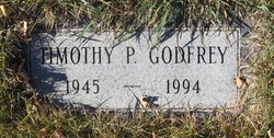
Timothy P “Tim” Godfrey
| Birth | : | 27 Mar 1945 Havre, Hill County, Montana, USA |
| Death | : | 1 Apr 1994 Big Sandy, Chouteau County, Montana, USA |
| Burial | : | Kahoka Cemetery, Kahoka, Clark County, USA |
| Coordinate | : | 40.4274600, -91.7114500 |
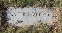
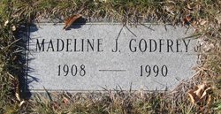
| Description | : | Obit from Find A Grave contributor "Cara": The Mountaineer, Big Sandy, MT, 6 Apr 1994 (excerpt) Timothy P. "Tim" Godfrey, 49, who owned and operated TV Land and Meadowgold in Big Sandy with his wife Gloria, died suddenly April 1, 1994, at the Big Sandy Medical Center of an apparent heart attack. Godfrey as born Mar. 27, 1945, at Havre, MT, the son of Walter and Madeline (Kessler)Godfrey. He was raised and attended school in Big Sandy and graduated from Big Sandy High School in 1963. His training was received from home correspondence courses from the National Radio and... Read More |
frequently asked questions (FAQ):
-
Where is Timothy P “Tim” Godfrey's memorial?
Timothy P “Tim” Godfrey's memorial is located at: Kahoka Cemetery, Kahoka, Clark County, USA.
-
When did Timothy P “Tim” Godfrey death?
Timothy P “Tim” Godfrey death on 1 Apr 1994 in Big Sandy, Chouteau County, Montana, USA
-
Where are the coordinates of the Timothy P “Tim” Godfrey's memorial?
Latitude: 40.4274600
Longitude: -91.7114500
Family Members:
Parent
Flowers:


Nearby Cemetories:
1. Kahoka Cemetery
Kahoka, Clark County, USA
Coordinate: 40.4274600, -91.7114500
2. Saint Paul Cemetery
Kahoka, Clark County, USA
Coordinate: 40.4357986, -91.7375031
3. Clark City Cemetery
Kahoka, Clark County, USA
Coordinate: 40.4127998, -91.6821976
4. Clark County Poor Farm Cemetery
Clark County, USA
Coordinate: 40.4025000, -91.6928000
5. Waterloo Cemetery
Clark County, USA
Coordinate: 40.4523900, -91.6666600
6. Medill Cemetery
Clark County, USA
Coordinate: 40.4435997, -91.7758026
7. Sugar Creek Cemetery
Clark County, USA
Coordinate: 40.3828011, -91.6688995
8. Galland Cemetery
Peaksville, Clark County, USA
Coordinate: 40.4858551, -91.6997452
9. Union Cemetery
Kahoka, Clark County, USA
Coordinate: 40.3704800, -91.7539200
10. Revere Cemetery
Revere, Clark County, USA
Coordinate: 40.4981400, -91.6787900
11. Ashton Methodist Cemetery
Ashton, Clark County, USA
Coordinate: 40.4515273, -91.8053091
12. New Revere Cemetery
Revere, Clark County, USA
Coordinate: 40.4996050, -91.6792350
13. Northrup Cemetery
Revere, Clark County, USA
Coordinate: 40.5000000, -91.6808014
14. Lillard Cemetery
Kahoka, Clark County, USA
Coordinate: 40.3601820, -91.7597010
15. Honey Creek Cemetery
Saint Patrick, Clark County, USA
Coordinate: 40.3527985, -91.6838989
16. Oak Hill Cemetery
Wayland, Clark County, USA
Coordinate: 40.4219017, -91.6057968
17. Prairie Church Cemetery
Revere, Clark County, USA
Coordinate: 40.4831009, -91.6324997
18. Cedar Grove Cemetery
Clark County, USA
Coordinate: 40.3472800, -91.7405800
19. Peaksville Cemetery
Peaksville, Clark County, USA
Coordinate: 40.5149994, -91.7080994
20. Walker Cemetery
Clark County, USA
Coordinate: 40.5161018, -91.6821976
21. Turtle Cemetery
Neeper, Clark County, USA
Coordinate: 40.3394630, -91.7640140
22. Beaird Cemetery
Clark County, USA
Coordinate: 40.4934400, -91.6178400
23. Anthony Family Cemetery
Clark County, USA
Coordinate: 40.4934387, -91.8065643
24. Duty Family Cemetery
Peaksville, Clark County, USA
Coordinate: 40.5255775, -91.7077713