
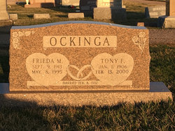
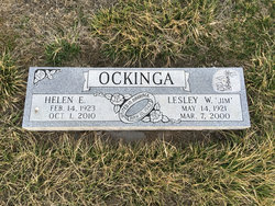
Tonjes Friedrich “Tony” Ockinga
| Birth | : | 1 Jan 1906 Inland, Clay County, Nebraska, USA |
| Death | : | 12 Feb 2000 Grand Island, Hall County, Nebraska, USA |
| Burial | : | Olive Branch Christian Church Cemetery, Norge, James City County, USA |
| Coordinate | : | 37.3755000, -76.7856000 |
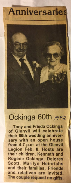
| Description | : | Sunday, Feb. 13, 2000 Glenvil resident Tony F. Ockinga, 94, died Sunday, Feb. 13, 2000, at St. Francis Medical Center in Grand Island. Services are 11 a.m. Thursday at Immanuel Lutheran Church in Glenvil with the Rev. Tim Wiggins officiating. Burial will be in the Glenvil Cem. Visitation is until 9 p.m. today, 9 a.m. to 9 p.m. Wednesday at Butler-Volland Funeral Home in Hastings and one hour prior to services Thursday at the church. Mr. Ockinga was born Jan. 1, 1906, to Henry and Katie (Onken) Ockinga in Inland Township, Clay County. In 1929 he started farming in the Clay County area.... Read More |
frequently asked questions (FAQ):
-
Where is Tonjes Friedrich “Tony” Ockinga's memorial?
Tonjes Friedrich “Tony” Ockinga's memorial is located at: Olive Branch Christian Church Cemetery, Norge, James City County, USA.
-
When did Tonjes Friedrich “Tony” Ockinga death?
Tonjes Friedrich “Tony” Ockinga death on 12 Feb 2000 in Grand Island, Hall County, Nebraska, USA
-
Where are the coordinates of the Tonjes Friedrich “Tony” Ockinga's memorial?
Latitude: 37.3755000
Longitude: -76.7856000
Family Members:
Parent

Spouse

Siblings
Children
Flowers:


Nearby Cemetories:
1. James City Chapel Cemetery
Norge, James City County, USA
Coordinate: 37.3713000, -76.7754000
2. Our Saviours Evangelical Lutheran Church Cemetery
Norge, James City County, USA
Coordinate: 37.3699000, -76.7746000
3. Bethany Cemetery of Our Saviours Lutheran Church
Norge, James City County, USA
Coordinate: 37.3793900, -76.7678100
4. Hickory Neck Church Cemetery
Toano, James City County, USA
Coordinate: 37.3934000, -76.8038000
5. Sunnyside Cemetery
James City County, USA
Coordinate: 37.3822550, -76.8212990
6. Chickahominy Baptist Church Cemetery
Toano, James City County, USA
Coordinate: 37.3551000, -76.8178000
7. Marston Family Cemetery
Lightfoot, James City County, USA
Coordinate: 37.3453860, -76.7687260
8. Saint Johns Baptist Church Cemetery
Toano, James City County, USA
Coordinate: 37.3813800, -76.8284000
9. Shiloh Baptist Church Cemetery
Croaker, James City County, USA
Coordinate: 37.3994500, -76.7528600
10. Smith Memorial Baptist Church Cemetery
Lightfoot, James City County, USA
Coordinate: 37.3431000, -76.7574000
11. Riverview Cemetery
Norge, James City County, USA
Coordinate: 37.3908430, -76.7385070
12. Richardsons Family Burial Ground
Croaker, James City County, USA
Coordinate: 37.3890000, -76.7353000
13. Zion Baptist Church Cemetery
Lightfoot, James City County, USA
Coordinate: 37.3376000, -76.7537000
14. Peach Park Cemetery
Toano, James City County, USA
Coordinate: 37.3726130, -76.8455030
15. Cowles - Spencer Cemetery
James City County, USA
Coordinate: 37.3178370, -76.7865370
16. Cowles Family Cemetery
Diascund, James City County, USA
Coordinate: 37.3817860, -76.8609850
17. New Zion Baptist Church Cemetery
Williamsburg West, James City County, USA
Coordinate: 37.3150000, -76.7812300
18. Nightengale - Bulifant Cemetery
Williamsburg West, James City County, USA
Coordinate: 37.3174830, -76.7625090
19. Williamsburg Memorial Park
Williamsburg West, James City County, USA
Coordinate: 37.3191000, -76.7390190
20. Mount Pilgrim Baptist Church Cemetery
James City County, USA
Coordinate: 37.3464000, -76.7051600
21. Murdoch-Austin Cemetery
Centerville, James City County, USA
Coordinate: 37.3044891, -76.7912598
22. James River Baptist Church Cemetery
Williamsburg West, James City County, USA
Coordinate: 37.3030360, -76.8028830
23. King of Glory Lutheran Church Memorial Garden
James City County, USA
Coordinate: 37.3025470, -76.7516200
24. Drewry Family Cemetery
Lanexa, James City County, USA
Coordinate: 37.3949044, -76.8858588