
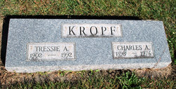
Tressie Annie Ruth Pirie Kropf
| Birth | : | 15 Sep 1902 |
| Death | : | Feb 1992 |
| Burial | : | Paton Cemetery, Paton, Greene County, USA |
| Coordinate | : | 42.1624985, -94.2433014 |
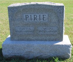
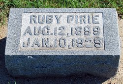
| Description | : | Children of James and Emeline Smith Pirie: Ruby Mae (1899-1929) Bertha (1900-1984) Tressie Annie Ruth (1902-1992) James Leroy (1905-1980) Verlin (1908-1993) Fern I. (1915-1999) Earl E. (1922-2006) U.S., Social Security Death Index, 1935-Current Name: Tressie A. Kropf Born: 15 Sep 1902 Died: Feb 1992 State (Year) SSN issued: Iowa (Before 1951) Web: Obituary Daily Times Index, 1995-2012 Name: Tressie Annie Ruth (Pirie) Kropf Publication Date: 27 Feb 1992 Publication Place: United States Death Date: abt 1992 Death Place: Age at Death: 89 Birth Date: Abt 1903 URL: http://obits.rootsweb.ancestry... |
frequently asked questions (FAQ):
-
Where is Tressie Annie Ruth Pirie Kropf's memorial?
Tressie Annie Ruth Pirie Kropf's memorial is located at: Paton Cemetery, Paton, Greene County, USA.
-
When did Tressie Annie Ruth Pirie Kropf death?
Tressie Annie Ruth Pirie Kropf death on Feb 1992 in
-
Where are the coordinates of the Tressie Annie Ruth Pirie Kropf's memorial?
Latitude: 42.1624985
Longitude: -94.2433014
Family Members:
Parent

Spouse

Siblings
Flowers:


Nearby Cemetories:
1. Paton Cemetery
Paton, Greene County, USA
Coordinate: 42.1624985, -94.2433014
2. Dawson Cemetery
Paton, Greene County, USA
Coordinate: 42.1655998, -94.3283005
3. Renner Cemetery
Boone County, USA
Coordinate: 42.1380420, -94.1256570
4. Lost Grove Cemetery
Harcourt, Webster County, USA
Coordinate: 42.2583008, -94.2331009
5. Swedish Lutheran Church Cemetery
Dayton, Webster County, USA
Coordinate: 42.2175000, -94.1065000
6. Lawn Cemetery
Boone County, USA
Coordinate: 42.1771011, -94.0867996
7. Union Cemetery
Boxholm, Boone County, USA
Coordinate: 42.1369019, -94.0852966
8. Grand Ridge Cemetery
Beaver, Boone County, USA
Coordinate: 42.0786018, -94.1157990
9. Gowrie Township Cemetery
Gowrie, Webster County, USA
Coordinate: 42.2813988, -94.3043976
10. Mount Calvary Cemetery
Grand Junction, Greene County, USA
Coordinate: 42.0266000, -94.2325000
11. Beaver Cemetery
Beaver, Boone County, USA
Coordinate: 42.0462000, -94.1446000
12. Junction Township Cemetery
Grand Junction, Greene County, USA
Coordinate: 42.0236015, -94.2593994
13. Maple Grove Cemetery
Boxholm, Boone County, USA
Coordinate: 42.0793690, -94.0859890
14. Maas Cemetery
Boone County, USA
Coordinate: 42.0908012, -94.0618973
15. Pilot Mound Cemetery
Pilot Mound, Boone County, USA
Coordinate: 42.1636200, -94.0282600
16. Christ the King Catholic Cemetery
Dayton, Webster County, USA
Coordinate: 42.2601929, -94.0727539
17. Dayton Cemetery
Dayton, Webster County, USA
Coordinate: 42.2675000, -94.0755000
18. Highland Township Cemetery
Churdan, Greene County, USA
Coordinate: 42.1518310, -94.4699120
19. Saint Joseph Cemetery
Jefferson, Greene County, USA
Coordinate: 42.0289001, -94.3818970
20. Reading Cemetery
Farnhamville, Calhoun County, USA
Coordinate: 42.2593994, -94.4325027
21. Jefferson Cemetery
Jefferson, Greene County, USA
Coordinate: 42.0133018, -94.3591995
22. Runyan Cemetery
Pilot Mound, Boone County, USA
Coordinate: 42.1749992, -94.0015030
23. Our Saviour Cemetery
Callender, Webster County, USA
Coordinate: 42.3396988, -94.3153000
24. Linn Cemetery
Pilot Mound, Boone County, USA
Coordinate: 42.2045330, -93.9970230