
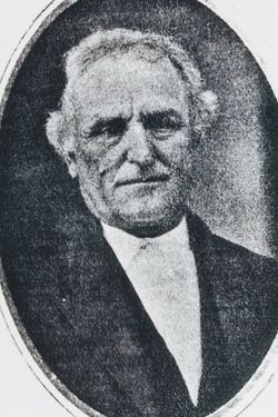
| Birth | : | 1 Jan 1800 Harrison County, West Virginia, USA |
| Death | : | 1 Nov 1870 Richardson County, Nebraska, USA |
| Burial | : | Fairview Cemetery, West Hartford, Hartford County, USA |
| Coordinate | : | 41.7630997, -72.7553024 |
| Inscription | : | Aged 70y 4m 14d |
| Description | : | "The Sabbath Recorder", Vol 26, No 52, p 207, Dec 22, 1870. At his residence, Long Branch, Nebraska, Nov. 1st, 1870, of dropsy, Uriah Davis, in the 71st year of his age. Father Davis embraced religion at the age of sixteen, and united with the Seventh-day Baptist Church at Salem, West Virginia. From that church he made the following removals: To Northampton. Ohio, to Jackson, Ohio, to Southampton, Ill., to Welton, Iowa, and to Long Branch, Nebraska, uniting with the several Seventh-day Baptist churches, living a consistent Christian, devoted to God, having the well wishes of all his brethren. His last sufferings were intense and... Read More |
frequently asked questions (FAQ):
-
Where is Uriah Fidelo Davis's memorial?
Uriah Fidelo Davis's memorial is located at: Fairview Cemetery, West Hartford, Hartford County, USA.
-
When did Uriah Fidelo Davis death?
Uriah Fidelo Davis death on 1 Nov 1870 in Richardson County, Nebraska, USA
-
Where are the coordinates of the Uriah Fidelo Davis's memorial?
Latitude: 41.7630997
Longitude: -72.7553024
Family Members:
Parent
Spouse

Siblings
Children
Flowers:


Nearby Cemetories:
1. Fairview Cemetery
West Hartford, Hartford County, USA
Coordinate: 41.7630997, -72.7553024
2. Saint James's Memorial Garden
West Hartford, Hartford County, USA
Coordinate: 41.7607690, -72.7473780
3. Old Center Cemetery
West Hartford, Hartford County, USA
Coordinate: 41.7642365, -72.7415085
4. First Church Memorial Garden
West Hartford, Hartford County, USA
Coordinate: 41.7614480, -72.7414750
5. Westminster Presbyterian Church Memorial Garden
West Hartford, Hartford County, USA
Coordinate: 41.7538110, -72.7626650
6. North Cemetery
West Hartford, Hartford County, USA
Coordinate: 41.7672005, -72.7418976
7. Quaker Cemetery
West Hartford, Hartford County, USA
Coordinate: 41.7593575, -72.7289581
8. Saint Johns Episcopal Church Cloister Garden
West Hartford, Hartford County, USA
Coordinate: 41.7650240, -72.7174320
9. Sisters of Saint Joseph Cemetery
West Hartford, Hartford County, USA
Coordinate: 41.7549400, -72.7181091
10. Saint Mary Cemetery
West Hartford, Hartford County, USA
Coordinate: 41.7844391, -72.7279816
11. Holy Family Monastery
West Hartland, Hartford County, USA
Coordinate: 41.7343110, -72.7737120
12. Holy Family Cemetery
West Hartford, Hartford County, USA
Coordinate: 41.7343010, -72.7737080
13. Immanuel Congregational Church Memorial Garden
Hartford, Hartford County, USA
Coordinate: 41.7681920, -72.7017000
14. Unitarian Society of Hartford Memorial Garden
Hartford County, USA
Coordinate: 41.7888072, -72.7128570
15. Teferes Israel Cemetery
West Hartford, Hartford County, USA
Coordinate: 41.7292252, -72.7171555
16. Beth Jacob Cemetery
West Hartford, Hartford County, USA
Coordinate: 41.7270950, -72.7204920
17. Temple Sinai Memorial Park
Newington, Hartford County, USA
Coordinate: 41.7188850, -72.7428170
18. Trinity Church Memorial Garden
Hartford, Hartford County, USA
Coordinate: 41.7688408, -72.6936417
19. Asylum Hill Congregational Church
West Hartford, Hartford County, USA
Coordinate: 41.7699550, -72.6915950
20. Zion Hill Cemetery
Hartford, Hartford County, USA
Coordinate: 41.7550011, -72.6917038
21. Agudas Achim Cemetery
Hartford, Hartford County, USA
Coordinate: 41.7549200, -72.6915300
22. Congregation Adas Israel Cemetery
Hartford, Hartford County, USA
Coordinate: 41.7553291, -72.6898804
23. Beth Israel Cemetery
Hartford, Hartford County, USA
Coordinate: 41.7556700, -72.6893500
24. Trinity College Chapel Memorial Garden
Hartford, Hartford County, USA
Coordinate: 41.7488870, -72.6902355