
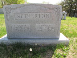
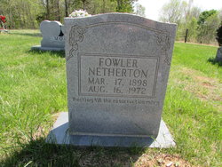
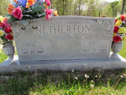
Vanas Netherton
| Birth | : | 10 Jan 1890 Clay County, Tennessee, USA |
| Death | : | 10 May 1964 Tipton, Tipton County, Indiana, USA |
| Burial | : | Stony Knoll United Methodist Church Cemetery, Stony Knoll, Surry County, USA |
| Coordinate | : | 36.3121109, -80.6739197 |
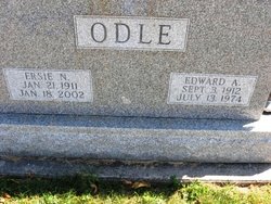
| Description | : | Info from Findagrave member 47252942 Son of James Monroe and Arielle (Rhoton) Netherton. Married Bessie Denton on October 9, 1909 in Moss, TN. Survived by the following children: Ambers Netherton of Tipton, IN; Amos Netherton of Moss, TN; Mrs. Emma Adams of Tipton, IN; Herman Netherton of Alexandria, IN; Raymond Netherton of Tipton, IN; Mrs. Erma Key of Tipton, IN; Verna Hubbartt of Tipton, IN; Ina Taylor of Tipton, IN; Jewell Kerr of Tipton, IN; and Rutha Belle Nash of Tipton, IN. Also survived by four sisters: Mrs. Ercie Odle of Tipton, IN; Dona Crowe of Illinois; Dora Crowe of Kentucky; and... Read More |
frequently asked questions (FAQ):
-
Where is Vanas Netherton's memorial?
Vanas Netherton's memorial is located at: Stony Knoll United Methodist Church Cemetery, Stony Knoll, Surry County, USA.
-
When did Vanas Netherton death?
Vanas Netherton death on 10 May 1964 in Tipton, Tipton County, Indiana, USA
-
Where are the coordinates of the Vanas Netherton's memorial?
Latitude: 36.3121109
Longitude: -80.6739197
Family Members:
Parent
Spouse

Siblings
Children
Flowers:


Nearby Cemetories:
1. Stony Knoll United Methodist Church Cemetery
Stony Knoll, Surry County, USA
Coordinate: 36.3121109, -80.6739197
2. Butcher Graveyard
Stony Knoll, Surry County, USA
Coordinate: 36.3072710, -80.6855890
3. William Stanley Family Cemetery
Stony Knoll, Surry County, USA
Coordinate: 36.3169920, -80.6579960
4. Baker-Crowder Cemetery
Stony Knoll, Surry County, USA
Coordinate: 36.2991440, -80.6865850
5. Collins-McCormick-Hudson Cemetery
Stony Knoll, Surry County, USA
Coordinate: 36.2953380, -80.6800080
6. Bear Creek Baptist Church Cemetery
Fairview, Surry County, USA
Coordinate: 36.3237860, -80.6954340
7. Liberty Baptist Church Cemetery
Dobson, Surry County, USA
Coordinate: 36.3330345, -80.6722488
8. Stanley Family Cemetery
Stony Knoll, Surry County, USA
Coordinate: 36.2979620, -80.6937210
9. Copeland Baptist Church Cemetery
Copeland, Surry County, USA
Coordinate: 36.3255577, -80.6531677
10. Jenkins-Stanley Family Cemetery
Fairview, Surry County, USA
Coordinate: 36.3011436, -80.6974564
11. Mount Pleasant Baptist Cemetery
Fairview, Surry County, USA
Coordinate: 36.3024960, -80.6999610
12. Double Creek Church of Christ Cemetery
Copeland, Surry County, USA
Coordinate: 36.3128640, -80.6437320
13. Second Chance Church Cemetery
Fairview, Surry County, USA
Coordinate: 36.3248560, -80.7030870
14. Richard J. Stanley Family Cemetery
Fairview, Surry County, USA
Coordinate: 36.3213997, -80.7099991
15. James Martin Venable Family Cemetery
Surry County, USA
Coordinate: 36.3458611, -80.6760000
16. Wesley H. Whitaker Cemetery
Rockford, Surry County, USA
Coordinate: 36.2781670, -80.6558330
17. Fairview Baptist Church Cemetery
Fairview, Surry County, USA
Coordinate: 36.3277855, -80.7181091
18. Stanley Cemetery
Dobson, Surry County, USA
Coordinate: 36.3497420, -80.6878850
19. Anchored In Jesus Baptist Church Cemetery
Copeland, Surry County, USA
Coordinate: 36.3420110, -80.6418400
20. Chaney Family Cemetery
Dobson, Surry County, USA
Coordinate: 36.2961120, -80.7188000
21. Chandler-Hudson Cemetery
Rockford, Surry County, USA
Coordinate: 36.2731490, -80.6862910
22. Hamlin-Dobson Cemetery
Rockford, Surry County, USA
Coordinate: 36.2854200, -80.6363200
23. Atkins O'Neal Family Cemetery
Mount Airy, Surry County, USA
Coordinate: 36.3305680, -80.6293220
24. Rockford Baptist Church Cemetery
Rockford, Surry County, USA
Coordinate: 36.2757492, -80.6517792