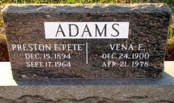
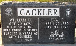
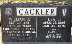
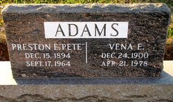
Vena E. Cackler Adams
| Birth | : | 24 Dec 1900 Lucas County, Iowa, USA |
| Death | : | 21 Apr 1978 USA |
| Burial | : | Failsworth Cemetery, Failsworth, Metropolitan Borough of Oldham, England |
| Coordinate | : | 53.5048760, -2.1537550 |
| Plot | : | Sec: New Lot: 428 |
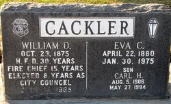
| Description | : | Vena, age 77, was a native of Lucas County, Iowa. She came to Hanford in 1905 with her late parents, former Fire Chief William D. and Eva Cackler. She graduated from local schools. She lived in Las Vegas the last three years before her death. Vena was a quiet soft spoken woman. She and her husband, Pete Adams, owned and operated Art's Print Shop in Hanford for a number of years. Both Vena and Pete were active in American Legion activities. They had a son, Arthur. United Methodist Church Full Membership on May 13, 1917, Certificate of Transfer to First UMC... Read More |
frequently asked questions (FAQ):
-
Where is Vena E. Cackler Adams's memorial?
Vena E. Cackler Adams's memorial is located at: Failsworth Cemetery, Failsworth, Metropolitan Borough of Oldham, England.
-
When did Vena E. Cackler Adams death?
Vena E. Cackler Adams death on 21 Apr 1978 in USA
-
Where are the coordinates of the Vena E. Cackler Adams's memorial?
Latitude: 53.5048760
Longitude: -2.1537550
Family Members:
Parent
Spouse
Siblings
Flowers:
Nearby Cemetories:
1. Failsworth Cemetery
Failsworth, Metropolitan Borough of Oldham, England
Coordinate: 53.5048760, -2.1537550
2. Failsworth Jewish Cemetery
Failsworth, Metropolitan Borough of Oldham, England
Coordinate: 53.5050270, -2.1534220
3. All Saints Churchyard
Newton Heath, Metropolitan Borough of Manchester, England
Coordinate: 53.5002260, -2.1777970
4. Oldham Crematorium
Oldham, Metropolitan Borough of Oldham, England
Coordinate: 53.5156810, -2.1332800
5. Hollinwood Cemetery
Oldham, Metropolitan Borough of Oldham, England
Coordinate: 53.5178170, -2.1329170
6. Saint Mary's Churchyard
Moston, Metropolitan Borough of Manchester, England
Coordinate: 53.5181740, -2.1763410
7. Droylsden Cemetery
Droylsden, Metropolitan Borough of Tameside, England
Coordinate: 53.4849400, -2.1529696
8. St. Joseph's Roman Catholic Churchyard
Moston, Metropolitan Borough of Manchester, England
Coordinate: 53.5149270, -2.1877070
9. St Cross Churchyard
Clayton, Metropolitan Borough of Manchester, England
Coordinate: 53.4832190, -2.1823530
10. Philips Park Cemetery
Miles Platting, Metropolitan Borough of Manchester, England
Coordinate: 53.4898020, -2.2007400
11. St. Peter's Churchyard
Ashton-Under-Lyne, Metropolitan Borough of Tameside, England
Coordinate: 53.4839340, -2.1054690
12. Christchurch Harpurhey Churchyard
Harpurhey, Metropolitan Borough of Manchester, England
Coordinate: 53.5115100, -2.2134800
13. Saint Stephens Churchyard
Audenshaw, Metropolitan Borough of Tameside, England
Coordinate: 53.4753000, -2.1151700
14. Manchester General Cemetery
Manchester, Metropolitan Borough of Manchester, England
Coordinate: 53.5062710, -2.2179570
15. St. Gabriel's Churchyard
Middleton, Metropolitan Borough of Rochdale, England
Coordinate: 53.5446736, -2.1742074
16. Blackley Jewish Cemetery
Blackley, Metropolitan Borough of Manchester, England
Coordinate: 53.5299377, -2.2097650
17. Chadderton Cemetery
Chadderton, Metropolitan Borough of Oldham, England
Coordinate: 53.5464860, -2.1468960
18. St. Peter's Churchyard
Blackley, Metropolitan Borough of Manchester, England
Coordinate: 53.5231200, -2.2188900
19. St. John the Evangelist Churchyard
Hurst, Metropolitan Borough of Tameside, England
Coordinate: 53.5001310, -2.0812490
20. Crumpsall Jewish Cemetery
Crumpsall, Metropolitan Borough of Manchester, England
Coordinate: 53.5124250, -2.2280270
21. St. Mary Church of England Churchyard
Oldham, Metropolitan Borough of Oldham, England
Coordinate: 53.5428030, -2.1104030
22. Blackley Presbyterian Chapel Chapelyard
Blackley, Metropolitan Borough of Manchester, England
Coordinate: 53.5233100, -2.2248110
23. Audenshaw Cemetery
Audenshaw, Metropolitan Borough of Tameside, England
Coordinate: 53.4653300, -2.1101560
24. Dukinfield Cemetery and Crematorium
Dukinfield, Metropolitan Borough of Tameside, England
Coordinate: 53.4800300, -2.0857150

