
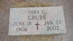
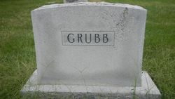
Vera C Duckers Grubb
| Birth | : | 18 Jun 1906 Brown County, Kansas, USA |
| Death | : | 27 Jan 2002 Holton, Jackson County, Kansas, USA |
| Burial | : | Wetmore Cemetery, Wetmore, Nemaha County, USA |
| Coordinate | : | 39.6396800, -95.8108400 |
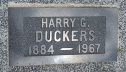
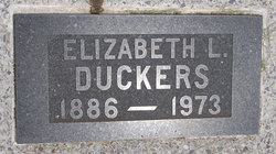
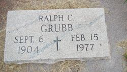
| Description | : | Vera C. Grubb, 95, Holton, died Jan. 27, 2002 at a Holton nursing home. She was born June 18, 1906 in Brown County, the daughter of Harry and Elizabeth Jones Duckers. Mrs. Grubb lived most of her life in the Wetmore and Netawaka communities. She lived in Hiawatha for 10 years before moving to Holton in 1992. Mrs. Grubb was a farm wife and worked for Slimaker Dress Factory for many years, retiring in 1971. She was a long time member of Wetmore United Methodist Church and the WSCS at the church. She married Ralph C. Grubb on Feb. 10,... Read More |
frequently asked questions (FAQ):
-
Where is Vera C Duckers Grubb's memorial?
Vera C Duckers Grubb's memorial is located at: Wetmore Cemetery, Wetmore, Nemaha County, USA.
-
When did Vera C Duckers Grubb death?
Vera C Duckers Grubb death on 27 Jan 2002 in Holton, Jackson County, Kansas, USA
-
Where are the coordinates of the Vera C Duckers Grubb's memorial?
Latitude: 39.6396800
Longitude: -95.8108400
Family Members:
Parent
Spouse
Siblings

Children
Flowers:


Nearby Cemetories:
1. Wetmore Cemetery
Wetmore, Nemaha County, USA
Coordinate: 39.6396800, -95.8108400
2. Wolfley Cemetery
Goff, Nemaha County, USA
Coordinate: 39.6454400, -95.8633900
3. South Powhattan Cemetery
Powhattan, Brown County, USA
Coordinate: 39.6608009, -95.7596970
4. Netawaka Cemetery
Netawaka, Jackson County, USA
Coordinate: 39.6075300, -95.7223700
5. Pleasant Grove Cemetery
Jackson County, USA
Coordinate: 39.5664000, -95.7789000
6. Barnes Cemetery
Goff, Nemaha County, USA
Coordinate: 39.6960983, -95.8824997
7. Granada Cemetery
Granada, Nemaha County, USA
Coordinate: 39.7324982, -95.7988968
8. Ontario Cemetery
Nemaha County, USA
Coordinate: 39.5663795, -95.8885193
9. Fairview Cemetery
Goff, Nemaha County, USA
Coordinate: 39.6831017, -95.9383011
10. Grant-Mjessepe Cemetery
Horton, Brown County, USA
Coordinate: 39.6663000, -95.6576000
11. Comet Cemetery
Powhattan Township, Brown County, USA
Coordinate: 39.7542600, -95.7340400
12. Kennekuk Church Cemetery
Horton, Brown County, USA
Coordinate: 39.7074600, -95.6672300
13. Jessepe Indian Cemetery
Horton, Brown County, USA
Coordinate: 39.6715000, -95.6438000
14. Capioma Cemetery
Capioma, Nemaha County, USA
Coordinate: 39.7805099, -95.8205719
15. Carmel Cemetery
Circleville, Jackson County, USA
Coordinate: 39.4984400, -95.7967700
16. Circleville Cemetery
Circleville, Jackson County, USA
Coordinate: 39.5014000, -95.8664017
17. Pleasant Hill Cemetery
Corning, Nemaha County, USA
Coordinate: 39.6895800, -95.9907400
18. Grasshopper Burial Ground
Powhattan Township, Brown County, USA
Coordinate: 39.7578020, -95.6949820
19. Saint Augustine Catholic Cemetery
Capioma Township, Nemaha County, USA
Coordinate: 39.7904282, -95.7897034
20. Soldier Cemetery
Soldier, Jackson County, USA
Coordinate: 39.5417900, -95.9654800
21. Woodlawn Cemetery
Woodlawn, Nemaha County, USA
Coordinate: 39.7905998, -95.8638992
22. Spring Hill Cemetery
Whiting, Jackson County, USA
Coordinate: 39.6021996, -95.6121979
23. Jonach Cemetery
Nemaha County, USA
Coordinate: 39.7925700, -95.8646600
24. Saint Patricks Cemetery
Corning, Nemaha County, USA
Coordinate: 39.6521988, -96.0250015