
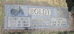
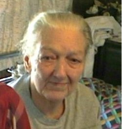
Vera Fern Canida Boldt
| Birth | : | 26 Mar 1932 Keokuk, Lee County, Iowa, USA |
| Death | : | 10 Jan 2005 Lebanon, Laclede County, Missouri, USA |
| Burial | : | Blue Grass Cemetery, Blue Grass, Scott County, USA |
| Coordinate | : | 41.5083008, -90.7574997 |
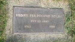
| Description | : | QC Times - Wednesday - May 4, 2005 Vera Fern Boldt, 72, of Eldridge, Mo., died Monday, Jan. 10, 2005, at St. John's Hospital, Lebanon, Mo. She was born March 26, 1932, in Keokuk, Iowa, to John Henry Canida and Idella Washburn Canida, who preceded her in death. She also was preceded in death by her husband, Henry Boldt, and husband, Alan Lobdell, a son, Henry F. Boldt, and three sisters, Margaret, Barbara and Betty. She was a nurse's aide. Survivors include two sons, Don Lobdell, and his wife, Barbara, and Rusty Boldt and his... Read More |
frequently asked questions (FAQ):
-
Where is Vera Fern Canida Boldt's memorial?
Vera Fern Canida Boldt's memorial is located at: Blue Grass Cemetery, Blue Grass, Scott County, USA.
-
When did Vera Fern Canida Boldt death?
Vera Fern Canida Boldt death on 10 Jan 2005 in Lebanon, Laclede County, Missouri, USA
-
Where are the coordinates of the Vera Fern Canida Boldt's memorial?
Latitude: 41.5083008
Longitude: -90.7574997
Family Members:
Parent

Spouse

Siblings
Children
Flowers:


Nearby Cemetories:
1. Blue Grass Cemetery
Blue Grass, Scott County, USA
Coordinate: 41.5083008, -90.7574997
2. Gabbert Family Cemetery
Blue Grass, Scott County, USA
Coordinate: 41.4939980, -90.7382000
3. Knaack Cemetery
Blue Grass, Scott County, USA
Coordinate: 41.5359535, -90.7511063
4. Burnside Family Cemetery
Blue Grass, Scott County, USA
Coordinate: 41.4821500, -90.7796360
5. Kistenmacher Cemetery
Little Groves, Scott County, USA
Coordinate: 41.5381012, -90.7260971
6. Saint Peters Cemetery
Buffalo, Scott County, USA
Coordinate: 41.4647522, -90.7265320
7. Rose Hill Cemetery
Buffalo, Scott County, USA
Coordinate: 41.4644012, -90.7256012
8. Montpelier Cemetery
Montpelier, Muscatine County, USA
Coordinate: 41.4636002, -90.8091965
9. Chapel Hill Cemetery
Davenport, Scott County, USA
Coordinate: 41.4939194, -90.6781921
10. Friday Family Cemetery
Davenport, Scott County, USA
Coordinate: 41.5093994, -90.6680984
11. Walcott Cemetery
Walcott, Scott County, USA
Coordinate: 41.5811005, -90.7763977
12. Parr Cemetery
Montpelier Township, Muscatine County, USA
Coordinate: 41.5189018, -90.8569031
13. Andalusia Cemetery
Andalusia, Rock Island County, USA
Coordinate: 41.4361000, -90.7172012
14. Patterson Cemetery
Montpelier, Muscatine County, USA
Coordinate: 41.5022000, -90.8760000
15. Fairmount Cemetery
Davenport, Scott County, USA
Coordinate: 41.5121994, -90.6371994
16. Dodge Family Cemetery
Fairport, Muscatine County, USA
Coordinate: 41.4750298, -90.8723681
17. Nye Cemetery
Montpelier, Muscatine County, USA
Coordinate: 41.4648552, -90.8677444
18. Tri-City Jewish Cemetery
Davenport, Scott County, USA
Coordinate: 41.5119362, -90.6311111
19. Dunlap Cemetery
Edgington, Rock Island County, USA
Coordinate: 41.4085040, -90.7460400
20. Holy Family Cemetery
Davenport, Scott County, USA
Coordinate: 41.5297012, -90.6211014
21. Davenport City Cemetery
Davenport, Scott County, USA
Coordinate: 41.5191760, -90.5997460
22. Putnam Museum of History and Natural Science
Davenport, Scott County, USA
Coordinate: 41.5309105, -90.6019287
23. Saint Marys Church Cemetery
Davenport, Scott County, USA
Coordinate: 41.5250015, -90.5958023
24. Sacred Heart Cemetery
Davenport, Scott County, USA
Coordinate: 41.5433006, -90.5916977