
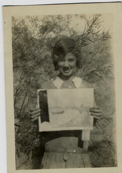

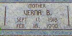
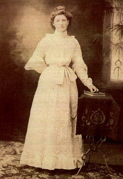
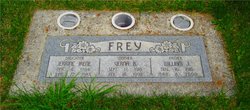
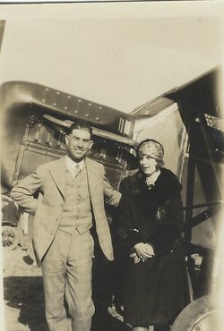
Verna Belle Huot Frey
| Birth | : | 17 Sep 1918 Goodnoe Hills, Klickitat County, Washington, USA |
| Death | : | 18 Feb 1990 The Dalles, Wasco County, Oregon, USA |
| Burial | : | Hopewell United Methodist Church Cemetery, Trinity, Randolph County, USA |
| Coordinate | : | 35.8549004, -79.9993515 |
| Plot | : | Block Section Lot 7.00 Space |
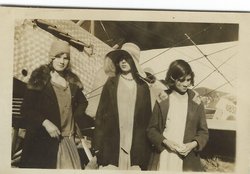
| Description | : | 1920 Sand Springs, Klickitat, Washington Lincoln Huot age 43 Oma Huot age34 Leland Huot age13 Mary Huot age11 Francis Huot age10 Gladys Huot age 8 Edna Huot age 5 Dolly Huot age 3 Verna Huot age 1 Doughty W.G. age 35 Oregon May wife age 31 Missouri Willard Son age 13 Oregon Ruth daughter age 11 Washington 1930 Census Spring Creek, Klickitat County, Washington Lincoln Huot age 53 b. Washington father b. France mother b. California general farmer Oma Huot age 44 b. WA father b. Germany mother b. Wisconsin Francis Huot age 20 daughter Gladys Huot age 18 daughter Edna Huot age 15 daughter Dolly Huot age 14 daughter Verna... Read More |
frequently asked questions (FAQ):
-
Where is Verna Belle Huot Frey's memorial?
Verna Belle Huot Frey's memorial is located at: Hopewell United Methodist Church Cemetery, Trinity, Randolph County, USA.
-
When did Verna Belle Huot Frey death?
Verna Belle Huot Frey death on 18 Feb 1990 in The Dalles, Wasco County, Oregon, USA
-
Where are the coordinates of the Verna Belle Huot Frey's memorial?
Latitude: 35.8549004
Longitude: -79.9993515
Family Members:
Parent
Spouse
Siblings


Children

Flowers:


Nearby Cemetories:
1. Hopewell United Methodist Church Cemetery
Trinity, Randolph County, USA
Coordinate: 35.8549004, -79.9993515
2. Temple Heights Baptist Church Cemetery
Randolph County, USA
Coordinate: 35.8753370, -80.0031360
3. Fairview United Methodist Church Cemetery
Randolph County, USA
Coordinate: 35.8684080, -79.9669370
4. Merrell Family Cemetery
Randolph County, USA
Coordinate: 35.8201904, -80.0306396
5. Trinity Cemetery #2
Trinity, Randolph County, USA
Coordinate: 35.8939410, -79.9735030
6. Andrews Grove Cemetery
Randolph County, USA
Coordinate: 35.8177986, -80.0299988
7. Trinity Cemetery
Trinity, Randolph County, USA
Coordinate: 35.9024470, -79.9883630
8. Mount Carmel United Methodist Church Cemetery
Davidson County, USA
Coordinate: 35.8446999, -80.0591965
9. Mount Vernon United Methodist Church Cemetery
Trinity, Randolph County, USA
Coordinate: 35.8593270, -79.9372480
10. Landmark Baptist Church Cemetery
Randolph County, USA
Coordinate: 35.9068810, -80.0129940
11. Pleasant Hill United Methodist Church Cemetery
Trinity, Randolph County, USA
Coordinate: 35.8037567, -80.0295029
12. Prospect United Methodist Church Cemetery
Randolph County, USA
Coordinate: 35.9022460, -80.0378800
13. Mount Gilead Church Cemetery
Trinity, Randolph County, USA
Coordinate: 35.8085556, -79.9584961
14. Poplar Ridge Friends Meeting Cemetery
Trinity, Randolph County, USA
Coordinate: 35.8058281, -79.9623566
15. Mount Zion Methodist Church Cemetery
Trinity, Randolph County, USA
Coordinate: 35.7930150, -80.0093300
16. Archdale United Methodist Church Columbarium
Archdale, Randolph County, USA
Coordinate: 35.9159740, -79.9741950
17. Shady Grove Baptist Church Cemetery
Randolph County, USA
Coordinate: 35.8673020, -79.9154950
18. Bethel United Methodist Church Cemetery
Archdale, Randolph County, USA
Coordinate: 35.8707360, -79.9104050
19. Laurel Hill Family Cemetery
Fuller Mill, Randolph County, USA
Coordinate: 35.7857800, -80.0405100
20. Mount Olive Wesleyan Church Cemetery
Sophia, Randolph County, USA
Coordinate: 35.8228920, -79.9131380
21. Glenola Community Cemetery
Glenola, Randolph County, USA
Coordinate: 35.8687190, -79.9052570
22. Springfield Friends Meeting House Cemetery
High Point, Guilford County, USA
Coordinate: 35.9315987, -79.9809113
23. Glenola Baptist Church Cemetery
Archdale, Randolph County, USA
Coordinate: 35.8688390, -79.9041930
24. Flint Hill United Church of Christ Cemetery
Sophia, Randolph County, USA
Coordinate: 35.8016080, -79.9248210