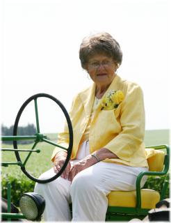
Vernette June Kollbaum Mesenbrink
| Birth | : | 23 Jun 1932 Ida Grove, Ida County, Iowa, USA |
| Death | : | 13 Apr 2014 Holstein, Ida County, Iowa, USA |
| Burial | : | Schaller Cemetery, Schaller, Sac County, USA |
| Coordinate | : | 42.5046000, -95.3117600 |
| Description | : | Vernette J. Mesenbrink June 23, 1932 - April 13, 2014 Schaller, Iowa Vernette J. Mesenbrink, age 81, passed peacefully, April 13, 2014, at the Good Samaritan Society of Holstein, Iowa, following a lengthy illness. She spent her final days surrounded by her family members. Vernette June Kollbaum was the oldest of four born to Matthew and Melinda (Hein) Kollbaum, of Ida Grove, on June 23, 1932. She was baptized and confirmed on December 23, 1951 at Trinity Lutheran Church in Ida Grove. She attended school until the 8th grade, at which time she went to work to help... Read More |
frequently asked questions (FAQ):
-
Where is Vernette June Kollbaum Mesenbrink's memorial?
Vernette June Kollbaum Mesenbrink's memorial is located at: Schaller Cemetery, Schaller, Sac County, USA.
-
When did Vernette June Kollbaum Mesenbrink death?
Vernette June Kollbaum Mesenbrink death on 13 Apr 2014 in Holstein, Ida County, Iowa, USA
-
Where are the coordinates of the Vernette June Kollbaum Mesenbrink's memorial?
Latitude: 42.5046000
Longitude: -95.3117600
Family Members:
Parent
Spouse
Siblings
Flowers:
Nearby Cemetories:
1. Schaller Cemetery
Schaller, Sac County, USA
Coordinate: 42.5046000, -95.3117600
2. Saint Josephs Catholic Church Cemetery
Schaller, Sac County, USA
Coordinate: 42.5035000, -95.3095000
3. German Methodist Cemetery
Schaller, Sac County, USA
Coordinate: 42.5045000, -95.2481000
4. Chase Cemetery
Sac County, USA
Coordinate: 42.5036011, -95.2288971
5. Immanuel Reformed Cemetery
Schaller, Sac County, USA
Coordinate: 42.5396996, -95.2294006
6. Cook Center Cemetery
Schaller, Sac County, USA
Coordinate: 42.4432983, -95.2649994
7. Maple Valley Township Cemetery
Alta, Buena Vista County, USA
Coordinate: 42.5752600, -95.3199980
8. Galva Township Cemetery East
Galva, Ida County, USA
Coordinate: 42.5031110, -95.4083200
9. Saint Johns Lutheran Cemetery
Galva, Ida County, USA
Coordinate: 42.5187700, -95.4183300
10. Saint John Lutheran Cemetery
Hanover, Buena Vista County, USA
Coordinate: 42.6053467, -95.3725739
11. Galva Township Cemetery
Galva, Ida County, USA
Coordinate: 42.5031013, -95.4664001
12. Sacred Heart Cemetery
Early, Sac County, USA
Coordinate: 42.4650002, -95.1446991
13. Emmanuel Cemetery
Cook Township, Sac County, USA
Coordinate: 42.3993988, -95.2063980
14. Early Union Cemetery
Early, Sac County, USA
Coordinate: 42.4578018, -95.1425018
15. Protestant Union Cemetery
Early, Sac County, USA
Coordinate: 42.4294014, -95.1483002
16. Diamond Cemetery
Cherokee County, USA
Coordinate: 42.6156006, -95.4480972
17. Buena Vista Memorial Park Cemetery
Storm Lake, Buena Vista County, USA
Coordinate: 42.6539001, -95.2339020
18. Sac County Farm Cemetery
Early, Sac County, USA
Coordinate: 42.4295560, -95.1175190
19. Nemaha Cemetery
Nemaha, Sac County, USA
Coordinate: 42.5102997, -95.0905991
20. Richland Cemetery
Sac County, USA
Coordinate: 42.3544006, -95.2238998
21. Storm Lake Cemetery
Storm Lake, Buena Vista County, USA
Coordinate: 42.6352800, -95.1744400
22. Woodlawn Cemetery
Alta, Buena Vista County, USA
Coordinate: 42.6730600, -95.2908300
23. Holstein Cemetery
Holstein, Ida County, USA
Coordinate: 42.5119019, -95.5436020
24. Salem Reform Cemetery
Sac County, USA
Coordinate: 42.3555984, -95.1866989


