
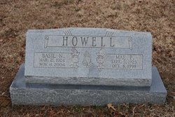
Vernie Mae Phillippe Howell
| Birth | : | 5 Sep 1925 Marye, Spotsylvania County, Virginia, USA |
| Death | : | 8 Oct 1998 Ashland, Hanover County, Virginia, USA |
| Burial | : | Northville Cemetery, North East, Erie County, USA |
| Coordinate | : | 42.2425003, -79.7649994 |
frequently asked questions (FAQ):
-
Where is Vernie Mae Phillippe Howell's memorial?
Vernie Mae Phillippe Howell's memorial is located at: Northville Cemetery, North East, Erie County, USA.
-
When did Vernie Mae Phillippe Howell death?
Vernie Mae Phillippe Howell death on 8 Oct 1998 in Ashland, Hanover County, Virginia, USA
-
Where are the coordinates of the Vernie Mae Phillippe Howell's memorial?
Latitude: 42.2425003
Longitude: -79.7649994
Family Members:
Parent
Siblings
Flowers:


Nearby Cemetories:
1. Northville Cemetery
North East, Erie County, USA
Coordinate: 42.2425003, -79.7649994
2. Phillips Cemetery
North East, Erie County, USA
Coordinate: 42.2324982, -79.7833023
3. Grimshaw Cemetery
North East, Erie County, USA
Coordinate: 42.2383000, -79.8242000
4. Grahamville Cemetery
North East, Erie County, USA
Coordinate: 42.2013000, -79.7917000
5. Quincy Rural Cemetery
Ripley, Chautauqua County, USA
Coordinate: 42.2633018, -79.7027969
6. Freeport Burial Ground
North East Township, Erie County, USA
Coordinate: 42.2385801, -79.8372134
7. South Ripley Cemetery
Ripley, Chautauqua County, USA
Coordinate: 42.1975000, -79.7097220
8. North East Cemetery
North East, Erie County, USA
Coordinate: 42.2094002, -79.8563995
9. East Ripley Cemetery
Ripley, Chautauqua County, USA
Coordinate: 42.2838880, -79.6716660
10. Holdridge Corners Cemetery
Mina, Chautauqua County, USA
Coordinate: 42.1716100, -79.7030300
11. Saint Gregory Cemetery
North East, Erie County, USA
Coordinate: 42.1949997, -79.8880997
12. Volusia Cemetery
Westfield, Chautauqua County, USA
Coordinate: 42.2508800, -79.6145300
13. Porter Cemetery
Chautauqua County, USA
Coordinate: 42.2331009, -79.6003036
14. Findley Lake Cemetery
Mina, Chautauqua County, USA
Coordinate: 42.1191660, -79.7380550
15. Mina Cemetery
Mina, Chautauqua County, USA
Coordinate: 42.1366997, -79.6746979
16. Shadduck Farm Burial Ground
Hornby, Erie County, USA
Coordinate: 42.1193500, -79.8202500
17. Hornby Cemetery
North East, Erie County, USA
Coordinate: 42.1320000, -79.8637400
18. South Harborcreek Cemetery
Harborcreek, Erie County, USA
Coordinate: 42.1506000, -79.9234000
19. Greenfield Cemetery
Little Hope, Erie County, USA
Coordinate: 42.0990400, -79.8201400
20. Old Miller Burying Ground
Little Hope, Erie County, USA
Coordinate: 42.0985400, -79.8219900
21. Amish Cemetery
Sherman, Chautauqua County, USA
Coordinate: 42.1189400, -79.6495000
22. Snake Hollow Cemetery
Erie County, USA
Coordinate: 42.0913000, -79.7818300
23. West Mina Cemetery
Mina, Chautauqua County, USA
Coordinate: 42.0889015, -79.7568970
24. Pleasant Valley Cemetery
Sherman, Chautauqua County, USA
Coordinate: 42.1283400, -79.6182300