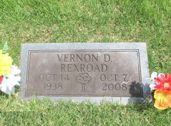
Vernon Dae Rexroad
| Birth | : | 14 Oct 1938 Chapel, Braxton County, West Virginia, USA |
| Death | : | 7 Oct 2008 Old Fields, Hardy County, West Virginia, USA |
| Burial | : | Chrisman Memorial Cemetery, Chapel, Braxton County, USA |
| Coordinate | : | 38.7378400, -80.8213000 |
| Description | : | Vernon Dae Rexroad, 69, of Old Pine Church Rd, Old Fields, WV, passed away Tuesday evening, October 7, 2008 at his residence. Born October 14, 1938 in Crooked Fork, WV he was a son of the late Clyde D & Beva (Dueley) Rexroad. Surviving is his wife, Bess (Jarvis) Rexroad; a son Bobby D Rexroad (Bonnie) of Burlington, WV; a daughter, Mary Ann Harvey ( Harold) of Old Field; three brothers, Junior D & David J Rexroad of Chapel, WV, Donald Rexroad of Ravenna, OH; four grandchildren and a great-granddaughter. Funeral Services will be conducted 2 pm... Read More |
frequently asked questions (FAQ):
-
Where is Vernon Dae Rexroad's memorial?
Vernon Dae Rexroad's memorial is located at: Chrisman Memorial Cemetery, Chapel, Braxton County, USA.
-
When did Vernon Dae Rexroad death?
Vernon Dae Rexroad death on 7 Oct 2008 in Old Fields, Hardy County, West Virginia, USA
-
Where are the coordinates of the Vernon Dae Rexroad's memorial?
Latitude: 38.7378400
Longitude: -80.8213000
Family Members:
Flowers:
Nearby Cemetories:
1. Chrisman Memorial Cemetery
Chapel, Braxton County, USA
Coordinate: 38.7378400, -80.8213000
2. Fairview Cemetery
Gassaway, Braxton County, USA
Coordinate: 38.7361100, -80.8206100
3. Fairview Church Cemetery
Chapel, Braxton County, USA
Coordinate: 38.7337800, -80.8213200
4. Chapel Methodist Church Cemetery
Chapel, Braxton County, USA
Coordinate: 38.7395640, -80.7885200
5. Engel Cemetery
Braxton County, USA
Coordinate: 38.7677994, -80.8197021
6. Starkey Cemetery
Belfont, Braxton County, USA
Coordinate: 38.7048189, -80.8484359
7. Jerusha Church Cemetery
Gassaway, Braxton County, USA
Coordinate: 38.6966160, -80.8205500
8. Carr Cemetery
Belfont, Braxton County, USA
Coordinate: 38.7038600, -80.8521300
9. George and Juliana Gerwig Cemetery
Braxton County, USA
Coordinate: 38.7813390, -80.8206810
10. Hosey Cemetery
Exchange, Braxton County, USA
Coordinate: 38.7775700, -80.7950630
11. Belknap Family-Bender Run Church Cemetery
Braxton County, USA
Coordinate: 38.7831630, -80.8286890
12. Rader Cemetery
Little Otter, Braxton County, USA
Coordinate: 38.7012333, -80.7701667
13. Aggie Perkins Cemetery
Chapel, Braxton County, USA
Coordinate: 38.7195560, -80.7529750
14. Currycomb Cemetery
Braxton County, USA
Coordinate: 38.7919006, -80.8503036
15. Karickhoff Cemetery
Braxton, Braxton County, USA
Coordinate: 38.7922480, -80.8501500
16. Houston-Carr Cemetery
Braxton County, USA
Coordinate: 38.6833000, -80.8538971
17. Rutherford Cemetery
Exchange, Braxton County, USA
Coordinate: 38.7828800, -80.7696100
18. Frederick Gerwig Memorial Cemetery
Braxton County, USA
Coordinate: 38.7954610, -80.7971710
19. Gerwig Family Cemetery
Braxton County, USA
Coordinate: 38.7954760, -80.7971520
20. James M. Carr Cemetery
Belfont, Braxton County, USA
Coordinate: 38.6840590, -80.8661250
21. Frame Family Cemetery
Gilmer County, USA
Coordinate: 38.7864810, -80.8782790
22. Whitesel Cemetery
Cedarville, Gilmer County, USA
Coordinate: 38.8048000, -80.8327000
23. Hackers Cemetery
Braxton, Braxton County, USA
Coordinate: 38.7015180, -80.7470340
24. Crooked Fork Baptist Church Cemetery
Perkins, Gilmer County, USA
Coordinate: 38.7714360, -80.8988930


