
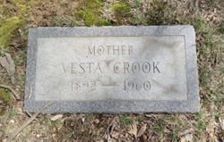
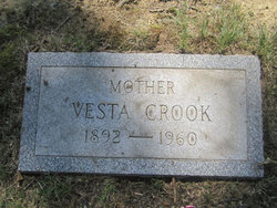
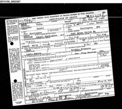
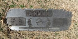
Vesta Adkins Crook
| Birth | : | 1 Nov 1892 West Virginia, USA |
| Death | : | 30 Aug 1960 Huntington, Cabell County, West Virginia, USA |
| Burial | : | Vista Memory Gardens, Truth or Consequences, Sierra County, USA |
| Coordinate | : | 33.1577900, -107.2618700 |
| Plot | : | 1918-34-18 |
frequently asked questions (FAQ):
-
Where is Vesta Adkins Crook's memorial?
Vesta Adkins Crook's memorial is located at: Vista Memory Gardens, Truth or Consequences, Sierra County, USA.
-
When did Vesta Adkins Crook death?
Vesta Adkins Crook death on 30 Aug 1960 in Huntington, Cabell County, West Virginia, USA
-
Where are the coordinates of the Vesta Adkins Crook's memorial?
Latitude: 33.1577900
Longitude: -107.2618700
Family Members:
Spouse
Children


Flowers:


Nearby Cemetories:
1. Vista Memory Gardens
Truth or Consequences, Sierra County, USA
Coordinate: 33.1577900, -107.2618700
2. Hot Springs Cemetery
Truth or Consequences, Sierra County, USA
Coordinate: 33.1389300, -107.2489900
3. Veterans Memorial Park Columbarium
Truth or Consequences, Sierra County, USA
Coordinate: 33.1206000, -107.2647000
4. Elephant Butte Cemetery
Sierra County, USA
Coordinate: 33.1444016, -107.1727982
5. Las Palomas Cemetery
Las Palomas, Sierra County, USA
Coordinate: 33.0631000, -107.2870000
6. Cuchillo Cemetery
Cuchillo, Sierra County, USA
Coordinate: 33.2329570, -107.3501980
7. Graham Cemetery
Sierra County, USA
Coordinate: 33.1067009, -107.0674973
8. Seco Creek Cemetery
Las Palomas, Sierra County, USA
Coordinate: 32.9849700, -107.3041920
9. Engle Cemetery
Sierra County, USA
Coordinate: 33.1789017, -107.0503006
10. Animas Creek Cemetery
Sierra County, USA
Coordinate: 32.9740000, -107.3478000
11. Cutter Cemetery
Sierra County, USA
Coordinate: 33.0553017, -107.0327988
12. Caballo Cemetery
Caballo, Sierra County, USA
Coordinate: 32.9244003, -107.3191986
13. Monticello Cemetery
Monticello, Sierra County, USA
Coordinate: 33.3922005, -107.4522018
14. Arrey Cemetery
Arrey, Sierra County, USA
Coordinate: 32.8481000, -107.3200000
15. Arrey Catholic Cemetery
Arrey, Sierra County, USA
Coordinate: 32.8460000, -107.3205000
16. Arrey Community Church Cemetery
Arrey, Sierra County, USA
Coordinate: 32.8132000, -107.3125000
17. Hillsboro Cemetery
Hillsboro, Sierra County, USA
Coordinate: 32.9172000, -107.5667000
18. Dines Ranch Cemetery
Lake Valley, Sierra County, USA
Coordinate: 33.2417000, -107.7136000
19. Hermosa Cemetery
Sierra County, USA
Coordinate: 33.1622009, -107.7311020
20. Santo Nino Cemetery
Chloride, Sierra County, USA
Coordinate: 33.3417015, -107.6793976
21. Chloride Cemetery
Chloride, Sierra County, USA
Coordinate: 33.3371506, -107.6832809
22. Garfield Cemetery
Garfield, Doña Ana County, USA
Coordinate: 32.7576600, -107.2653200
23. Kingston Cemetery
Sierra County, USA
Coordinate: 32.9124985, -107.7061005
24. Holy Cross Cemetery
Salem, Doña Ana County, USA
Coordinate: 32.7105000, -107.2090000