
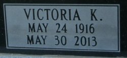
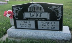
Victoria Katherine “Vickie” Hirsche Zaugg
| Birth | : | 24 May 1916 Wrentham, Lethbridge Census Division, Alberta, Canada |
| Death | : | 30 May 2013 Stirling, Lethbridge Census Division, Alberta, Canada |
| Burial | : | Stirling Cemetery, Stirling, Lethbridge Census Division, Canada |
| Coordinate | : | 49.5093400, -112.5380000 |
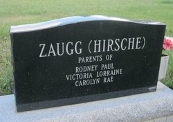
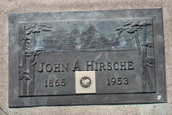
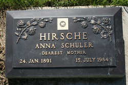
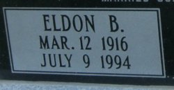
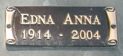
| Description | : | Wrentham History Book "Homestead Country" page 421 and 710. Stirling HIstory Book "Stirling Its Story and People" page 565 Spouse: Eldon Bohman Zaugg Parents: John Albert Hirsche and Anna Schuler Hirsche∼Beloved wife of the late Eldon Bohman Zaugg, passed away in Stirling on Thursday, May 30, 2013 at the age of 97 years.She is survived by her son Rodney Paul Zaugg of Medicine Hat, and daughters Victoria Lorraine Archibald of Stirling and Carolyn Rae (Timothy Kilner) Perkins of Layton, Utah, 20 grandchildren, 54 great grandchildren and 1 great great grandson, 2 sisters Rachel Bessie Moore, Joyce Marie Hirsche, brother... Read More |
frequently asked questions (FAQ):
-
Where is Victoria Katherine “Vickie” Hirsche Zaugg's memorial?
Victoria Katherine “Vickie” Hirsche Zaugg's memorial is located at: Stirling Cemetery, Stirling, Lethbridge Census Division, Canada.
-
When did Victoria Katherine “Vickie” Hirsche Zaugg death?
Victoria Katherine “Vickie” Hirsche Zaugg death on 30 May 2013 in Stirling, Lethbridge Census Division, Alberta, Canada
-
Where are the coordinates of the Victoria Katherine “Vickie” Hirsche Zaugg's memorial?
Latitude: 49.5093400
Longitude: -112.5380000
Family Members:
Parent
Spouse
Siblings


Nearby Cemetories:
1. Stirling Cemetery
Stirling, Lethbridge Census Division, Canada
Coordinate: 49.5093400, -112.5380000
2. Stirling Mennonite Church Cemetery
Stirling, Lethbridge Census Division, Canada
Coordinate: 49.4607570, -112.5387970
3. Temple Hill Cemetery
Raymond, Lethbridge Census Division, Canada
Coordinate: 49.4916300, -112.6605200
4. East Raymond Hutterite Colony Cemetery
Raymond, Lethbridge Census Division, Canada
Coordinate: 49.4185305, -112.5791329
5. Wolf Creek Hutterite Colony Cemetery
Stirling, Lethbridge Census Division, Canada
Coordinate: 49.4119142, -112.5163705
6. Wilson Siding Hutterite Cemetery
Wilson, Lethbridge Census Division, Canada
Coordinate: 49.6203914, -112.5781130
7. New York Hutterite Cemetery
Judson, Lethbridge Census Division, Canada
Coordinate: 49.5931870, -112.3956383
8. New Dayton Community Cemetery
New Dayton, Lethbridge Census Division, Canada
Coordinate: 49.4254300, -112.3601800
9. Lakeside Hutterite Colony Cemetery
Cranford, Lethbridge Census Division, Canada
Coordinate: 49.6685448, -112.3586315
10. Rock Lake Colony Cemetery
Coaldale, Lethbridge Census Division, Canada
Coordinate: 49.6219440, -112.2750000
11. Hutterville Hutterite Cemetery
Magrath, Claresholm Census Division, Canada
Coordinate: 49.3503165, -112.7701038
12. Coaldale Community Cemetery
Coaldale, Lethbridge Census Division, Canada
Coordinate: 49.7355600, -112.6242300
13. Coaldale Mennonite Cemetery
Coaldale, Lethbridge Census Division, Canada
Coordinate: 49.7355600, -112.6242300
14. Magrath Cemetery
Magrath, Claresholm Census Division, Canada
Coordinate: 49.3985700, -112.8648700
15. Hillridge Hutterite Colony Cemetery
Cranford, Lethbridge Census Division, Canada
Coordinate: 49.7196094, -112.3393464
16. Wrentham Cemetery
Wrentham, Lethbridge Census Division, Canada
Coordinate: 49.5231200, -112.1574800
17. Mountain View Cemetery
Lethbridge, Lethbridge Census Division, Canada
Coordinate: 49.6800385, -112.8297729
18. Rockport Colony Cemetery
Magrath, Claresholm Census Division, Canada
Coordinate: 49.3027780, -112.8136110
19. Indian Battle Park
Lethbridge, Lethbridge Census Division, Canada
Coordinate: 49.6928200, -112.8582900
20. Saint Patrick's Cemetery
Lethbridge, Lethbridge Census Division, Canada
Coordinate: 49.7084618, -112.8428726
21. Warner Memorial Cemetery
Warner, Lethbridge Census Division, Canada
Coordinate: 49.2914900, -112.2246800
22. Royal View Memorial Cemetery
Lethbridge, Lethbridge Census Division, Canada
Coordinate: 49.7518540, -112.8242250
23. Archmount Cemetery
Lethbridge, Lethbridge Census Division, Canada
Coordinate: 49.7057900, -112.9017500
24. Barnwell Cemetery
Barnwell, Lethbridge Census Division, Canada
Coordinate: 49.7691400, -112.2723800