

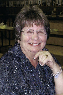


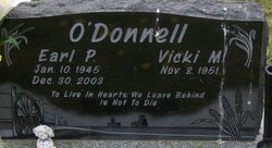
Victoria M. “Vicki” Werk O'Donnell
| Birth | : | 8 Nov 1951 Lethbridge, Lethbridge Census Division, Alberta, Canada |
| Death | : | 30 Aug 2011 Lethbridge, Lethbridge Census Division, Alberta, Canada |
| Burial | : | Warner Memorial Cemetery, Warner, Lethbridge Census Division, Canada |
| Coordinate | : | 49.2914900, -112.2246800 |
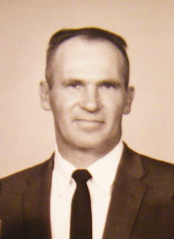
| Description | : | Mrs. Vicki O'Donnell of Warner, beloved wife of the late Earl O'Donnell, passed away after a short but courageous battle with cancer on Saturday, July 30, 2011 at the age of 59 years. She will be missed by her children: daughter Adena (Keith) Heppler, son Martin (Roberta) O'Donnell, her 3 precious grandsons Dylan, Holden, and Zachary Heppler, brothers Victor (Shelley Flegel) Werk, Larry (Brenda) Werk, Brad Werk and sister Diane Law; Mother-in-Law Eva O'Donnell, Sister-in-Law Evelyn Battle, and numerous nieces and nephews. She was predeceased by her parents Alfred Werk and Betty Ellis, Father-in-Law Elmer O'Donnell, Brother-in-Law Russel Battle and nephew Gary... Read More |
frequently asked questions (FAQ):
-
Where is Victoria M. “Vicki” Werk O'Donnell's memorial?
Victoria M. “Vicki” Werk O'Donnell's memorial is located at: Warner Memorial Cemetery, Warner, Lethbridge Census Division, Canada.
-
When did Victoria M. “Vicki” Werk O'Donnell death?
Victoria M. “Vicki” Werk O'Donnell death on 30 Aug 2011 in Lethbridge, Lethbridge Census Division, Alberta, Canada
-
Where are the coordinates of the Victoria M. “Vicki” Werk O'Donnell's memorial?
Latitude: 49.2914900
Longitude: -112.2246800
Family Members:
Parent
Spouse
Siblings

Flowers:


Nearby Cemetories:
1. Warner Memorial Cemetery
Warner, Lethbridge Census Division, Canada
Coordinate: 49.2914900, -112.2246800
2. New Dayton Community Cemetery
New Dayton, Lethbridge Census Division, Canada
Coordinate: 49.4254300, -112.3601800
3. Milk River Cemetery
Milk River, Lethbridge Census Division, Canada
Coordinate: 49.1442000, -112.0658700
4. Wolf Creek Hutterite Colony Cemetery
Stirling, Lethbridge Census Division, Canada
Coordinate: 49.4119142, -112.5163705
5. Wrentham Cemetery
Wrentham, Lethbridge Census Division, Canada
Coordinate: 49.5231200, -112.1574800
6. East Raymond Hutterite Colony Cemetery
Raymond, Lethbridge Census Division, Canada
Coordinate: 49.4185305, -112.5791329
7. Stirling Mennonite Church Cemetery
Stirling, Lethbridge Census Division, Canada
Coordinate: 49.4607570, -112.5387970
8. Prairie Home Hutterite Colony Cemetery
Wrentham, Lethbridge Census Division, Canada
Coordinate: 49.5291670, -111.9608330
9. Stirling Cemetery
Stirling, Lethbridge Census Division, Canada
Coordinate: 49.5093400, -112.5380000
10. New York Hutterite Cemetery
Judson, Lethbridge Census Division, Canada
Coordinate: 49.5931870, -112.3956383
11. Hillside Hutterite Colony Cemetery
Toole County, USA
Coordinate: 48.9788000, -112.0740000
12. Sweet Grass Cemetery
Sweet Grass, Toole County, USA
Coordinate: 48.9972120, -111.9966140
13. Rock Lake Colony Cemetery
Coaldale, Lethbridge Census Division, Canada
Coordinate: 49.6219440, -112.2750000
14. Allerston Cemetery
Milk River, Lethbridge Census Division, Canada
Coordinate: 49.1451500, -111.7664000
15. Holy Angels Cemetery Community
Coutts, Lethbridge Census Division, Canada
Coordinate: 48.9989440, -111.9649050
16. Coutts Cemetery
Coutts, Lethbridge Census Division, Canada
Coordinate: 48.9989690, -111.9647810
17. Temple Hill Cemetery
Raymond, Lethbridge Census Division, Canada
Coordinate: 49.4916300, -112.6605200
18. Hutterville Hutterite Cemetery
Magrath, Claresholm Census Division, Canada
Coordinate: 49.3503165, -112.7701038
19. Rockport Colony Cemetery
Magrath, Claresholm Census Division, Canada
Coordinate: 49.3027780, -112.8136110
20. Lakeside Hutterite Colony Cemetery
Cranford, Lethbridge Census Division, Canada
Coordinate: 49.6685448, -112.3586315
21. Crystal Spring Hutterite Colony Cemetery
Magrath, Claresholm Census Division, Canada
Coordinate: 49.1702490, -112.8048290
22. Wilson Siding Hutterite Cemetery
Wilson, Lethbridge Census Division, Canada
Coordinate: 49.6203914, -112.5781130
23. Rimrock Colony Cemetery
Toole County, USA
Coordinate: 48.8985000, -112.0980000
24. Masinasin Cemetery
Milk River, Lethbridge Census Division, Canada
Coordinate: 49.1302328, -111.6527199