
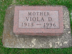

Viola Della Kaiser Jones
| Birth | : | 10 Oct 1913 Steamboat Rock, Hardin County, Iowa, USA |
| Death | : | 14 Oct 1996 Mason City, Cerro Gordo County, Iowa, USA |
| Burial | : | Riverside Cemetery, Rockford, Floyd County, USA |
| Coordinate | : | 43.0578003, -92.9464035 |
| Plot | : | Section 12 |
| Description | : | Viola D. Jones ROCKFORD, IOWA -- Viola D. Jones, 83, of 44 Eighth St. S.W., Rockford, died Monday, October 14, 1996, at the North Iowa Mercy Health Center East, Mason City. Funeral services will be held at 10:30 a.m. Thursday at the First United Methodist Church, 21 Third St. N.W., Rockford, with the Rev. Rosemary Rohde-Frank officiating. Burial will be in the Riverside Cemetery. Visitation will be held from 3 to 9 p.m. today at the Schumburg Funeral Home, 302 W. Main St., where the family will receive friends from 7 to 9 p.m.... Read More |
frequently asked questions (FAQ):
-
Where is Viola Della Kaiser Jones's memorial?
Viola Della Kaiser Jones's memorial is located at: Riverside Cemetery, Rockford, Floyd County, USA.
-
When did Viola Della Kaiser Jones death?
Viola Della Kaiser Jones death on 14 Oct 1996 in Mason City, Cerro Gordo County, Iowa, USA
-
Where are the coordinates of the Viola Della Kaiser Jones's memorial?
Latitude: 43.0578003
Longitude: -92.9464035
Family Members:
Parent

Spouse
Siblings

Children
Flowers:


Nearby Cemetories:
1. Riverside Cemetery
Rockford, Floyd County, USA
Coordinate: 43.0578003, -92.9464035
2. Ulsterville Cemetery
Ulster Township, Floyd County, USA
Coordinate: 43.0936012, -92.8842010
3. Flood Creek Cemetery
Floyd County, USA
Coordinate: 43.0391998, -92.8538971
4. Rock Grove Township Cemetery
Nora Springs, Floyd County, USA
Coordinate: 43.1227989, -92.9880981
5. Rudd Evergreen Cemetery
Rudd, Floyd County, USA
Coordinate: 43.1417007, -92.9214020
6. Park Cemetery
Nora Springs, Floyd County, USA
Coordinate: 43.1444016, -92.9982986
7. Saint Marys Catholic Cemetery
Roseville, Floyd County, USA
Coordinate: 43.0090000, -92.8134000
8. West Saint Charles United Methodist Cemetery
Floyd County, USA
Coordinate: 43.0580597, -92.7897186
9. Westside Cemetery
Marble Rock, Floyd County, USA
Coordinate: 42.9556007, -92.8739014
10. Hillside Cemetery
Marble Rock, Floyd County, USA
Coordinate: 42.9583015, -92.8666992
11. Spring Grove Cemetery
Nora Springs, Floyd County, USA
Coordinate: 43.1631012, -93.0211029
12. Owens Grove Cemetery
Cerro Gordo County, USA
Coordinate: 43.0825005, -93.1144180
13. Saint Patricks Catholic Cemetery
Dougherty, Cerro Gordo County, USA
Coordinate: 42.9227791, -93.0294418
14. Eden Presbyterian Cemetery
Meroa, Mitchell County, USA
Coordinate: 43.2131004, -92.9103012
15. West End Cemetery
Meroa, Mitchell County, USA
Coordinate: 43.2216682, -92.9250031
16. Oakwood Cemetery
Floyd, Floyd County, USA
Coordinate: 43.1178017, -92.7307968
17. Dudley Cemetery
Dudley (historical), Mitchell County, USA
Coordinate: 43.2252998, -92.8743973
18. Rock Creek Cemetery
Meroa, Mitchell County, USA
Coordinate: 43.2352791, -92.9225006
19. Halls Grove Cemetery
Greene, Butler County, USA
Coordinate: 42.8840100, -92.8782300
20. Rock Falls Cemetery
Rock Falls, Cerro Gordo County, USA
Coordinate: 43.2122192, -93.0858307
21. Pleasant Grove Cemetery
Powersville, Floyd County, USA
Coordinate: 42.9441986, -92.7446976
22. Calvary Cemetery
Osage, Mitchell County, USA
Coordinate: 43.2238998, -92.8300018
23. Riverside Cemetery
Charles City, Floyd County, USA
Coordinate: 43.0766983, -92.6881027
24. West Fork Cemetery
Franklin County, USA
Coordinate: 42.8918991, -93.0836029