
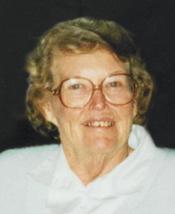
Viola May Hagan Cline
| Birth | : | 17 May 1928 Lexington, Dawson County, Nebraska, USA |
| Death | : | 10 Aug 2012 Holdrege, Phelps County, Nebraska, USA |
| Burial | : | Greenwood Cemetery, Lexington, Dawson County, USA |
| Coordinate | : | 40.7956467, -99.7286682 |
| Plot | : | DIV. E, BLOCK 13, LOT 4, SPACE 4. |
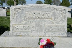
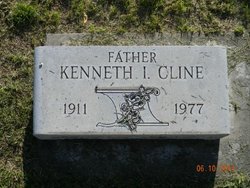
| Description | : | Viola May Cline, of Bertrand, Nebraska, passed away on Friday, August 10, 2012 at Christian Homes Care Community in Holdrege, Nebraska. Viola was born May 17, 1926 at Lexington, Nebraska, the second of six children born to Thomas James and Martha Marie (Sullivan) Hagan. Viola received her primary education and later graduated from Lexington Public Schools with the Class of 1944. Viola was united in marriage to Kenneth Irwin Cline on May 21, 1958 at the Nebraska State Capitol in Lincoln, Nebraska. The family was blessed with two daughters: Valerie and Sandra. The family made their home... Read More |
frequently asked questions (FAQ):
-
Where is Viola May Hagan Cline's memorial?
Viola May Hagan Cline's memorial is located at: Greenwood Cemetery, Lexington, Dawson County, USA.
-
When did Viola May Hagan Cline death?
Viola May Hagan Cline death on 10 Aug 2012 in Holdrege, Phelps County, Nebraska, USA
-
Where are the coordinates of the Viola May Hagan Cline's memorial?
Latitude: 40.7956467
Longitude: -99.7286682
Family Members:
Parent

Spouse
Siblings
Flowers:


Nearby Cemetories:
1. First United Methodist Church Columbarium
Lexington, Dawson County, USA
Coordinate: 40.7810000, -99.7397000
2. Saint Anns Cemetery
Lexington, Dawson County, USA
Coordinate: 40.7789001, -99.7114029
3. Evergreen Cemetery
Lexington, Dawson County, USA
Coordinate: 40.7639008, -99.6791992
4. Mount Hope Cemetery
Dawson County, USA
Coordinate: 40.8293991, -99.6733017
5. Hewitt Cemetery
Lexington, Dawson County, USA
Coordinate: 40.8588982, -99.7769012
6. Buffalo Grove Presbyterian Church Cemetery
Buffalo, Dawson County, USA
Coordinate: 40.8721000, -99.8270000
7. Hillside Cemetery
Dawson County, USA
Coordinate: 40.8946991, -99.7869034
8. Grace Cemetery
Cozad, Dawson County, USA
Coordinate: 40.8602982, -99.8644028
9. Robb Cemetery
Smithfield, Gosper County, USA
Coordinate: 40.6710691, -99.6996001
10. Saint Johns Lutheran Cemetery
Lexington, Dawson County, USA
Coordinate: 40.9019012, -99.8458023
11. Plum Creek Massacre Cemetery
Phelps County, USA
Coordinate: 40.6726840, -99.6058220
12. Overton Cemetery
Overton, Dawson County, USA
Coordinate: 40.7317009, -99.5222015
13. Cozad Cemetery
Cozad, Dawson County, USA
Coordinate: 40.8605995, -99.9475021
14. Quakerville Cemetery
Gosper County, USA
Coordinate: 40.6189003, -99.8097000
15. Cottonwood Cemetery
Dawson County, USA
Coordinate: 40.9322014, -99.9197006
16. Saint Patricks Cemetery
Eddyville, Dawson County, USA
Coordinate: 40.9747009, -99.6093979
17. Adullam Cemetery
Bertrand, Phelps County, USA
Coordinate: 40.6265000, -99.5856000
18. Fairview Cemetery
Dawson County, USA
Coordinate: 40.7719002, -99.9955978
19. Jewell Cemetery
Sumner, Dawson County, USA
Coordinate: 40.9599991, -99.5646973
20. Rose Hill Cemetery
Dawson County, USA
Coordinate: 40.9888992, -99.8442001
21. Elwood Cemetery
Elwood, Gosper County, USA
Coordinate: 40.5999300, -99.8397300
22. Rhinehart Cemetery
Cozad, Dawson County, USA
Coordinate: 40.9599000, -99.9105000
23. Buffalo First Lutheran Cemetery Old
Buffalo, Dawson County, USA
Coordinate: 41.0100000, -99.8152000
24. Buffalo First Lutheran Cemetery New
Buffalo, Dawson County, USA
Coordinate: 41.0127000, -99.8150000