

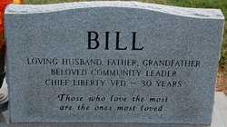

W W Husking “Bill” Misenheimer
| Birth | : | 13 Mar 1921 |
| Death | : | 28 Mar 2008 |
| Burial | : | Mount Washington Cemetery, Bethlehem, Grafton County, USA |
| Coordinate | : | 44.2797620, -71.6944050 |
| Plot | : | Row 29 |
| Description | : | W.W. Husking "Bill" Misenheimer, 87, passed away Friday, March 28, 2008, at Rowan Regional Medical Center. Mr. Misenheimer was born March 13, 1921 in Rowan County. He was the son of the late Delmar Misenheimer and Carrie Trexler Misenheimer. He was educated in the Rowan County schools and graduated from Rockwell High School. He was owner and operator of Liberty Feed and Seed for over 60 years. Bill was a member of St. Matthews Lutheran Church. He was a Veteran of the U.S. Army-Air Force and was a gunner aboard an A-26 invader. A founding member of Liberty Volunteer Fire... Read More |
frequently asked questions (FAQ):
-
Where is W W Husking “Bill” Misenheimer's memorial?
W W Husking “Bill” Misenheimer's memorial is located at: Mount Washington Cemetery, Bethlehem, Grafton County, USA.
-
When did W W Husking “Bill” Misenheimer death?
W W Husking “Bill” Misenheimer death on 28 Mar 2008 in
-
Where are the coordinates of the W W Husking “Bill” Misenheimer's memorial?
Latitude: 44.2797620
Longitude: -71.6944050
Family Members:
Parent

Spouse

Flowers:


Nearby Cemetories:
1. Mount Washington Cemetery
Bethlehem, Grafton County, USA
Coordinate: 44.2797620, -71.6944050
2. Bethlehem Cemetery
Bethlehem, Grafton County, USA
Coordinate: 44.2803870, -71.6945420
3. Maple Street Cemetery
Bethlehem, Grafton County, USA
Coordinate: 44.2858370, -71.6846050
4. Saint Rose of Lima Cemetery
Bethlehem, Grafton County, USA
Coordinate: 44.2950200, -71.7391700
5. Eli Wallace Horse Cemetery
Littleton, Grafton County, USA
Coordinate: 44.2981300, -71.7714081
6. Wilkins Cemetery
Littleton, Grafton County, USA
Coordinate: 44.3343430, -71.7301600
7. Elmwood Cemetery
Franconia, Grafton County, USA
Coordinate: 44.2219009, -71.7474976
8. Glenwood Cemetery
Littleton, Grafton County, USA
Coordinate: 44.3116100, -71.7901400
9. Clark Cemetery
Littleton, Grafton County, USA
Coordinate: 44.3449750, -71.7489410
10. Saint Rose of Lima New Catholic Cemetery
Littleton, Grafton County, USA
Coordinate: 44.3130989, -71.7949982
11. Farr Cemetery
Littleton, Grafton County, USA
Coordinate: 44.3363000, -71.7744800
12. Ammonoosuc Meadows Cemetery
Littleton, Grafton County, USA
Coordinate: 44.3013992, -71.8043976
13. Hildreth Cemetery
Littleton, Grafton County, USA
Coordinate: 44.3414680, -71.7762400
14. Rosebrook Cemetery
Carroll, Coos County, USA
Coordinate: 44.2739400, -71.5709600
15. Burns Cemetery
Whitefield, Coos County, USA
Coordinate: 44.3577200, -71.6312200
16. Kimball Hill Cemetery
Whitefield, Coos County, USA
Coordinate: 44.3569660, -71.6229410
17. Willow Cemetery
Franconia, Grafton County, USA
Coordinate: 44.1968994, -71.7530975
18. Ladd Cemetery
Dalton, Coos County, USA
Coordinate: 44.3790440, -71.6550400
19. Adams-Pfaelzer Cemetery
Littleton, Grafton County, USA
Coordinate: 44.3185210, -71.8283880
20. Sunnyside Cemetery
Sugar Hill, Grafton County, USA
Coordinate: 44.2130300, -71.8061600
21. Straw Cemetery
Carroll, Coos County, USA
Coordinate: 44.3101300, -71.5507000
22. Wheeler Hill Cemetery
Littleton, Grafton County, USA
Coordinate: 44.3472230, -71.8137220
23. Wheeler Family Cemetery
Littleton, Grafton County, USA
Coordinate: 44.3467130, -71.8143330
24. Saint Margaret Cemetery
Twin Mountain, Coos County, USA
Coordinate: 44.2681160, -71.5428391