
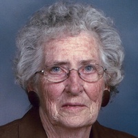
Wanda Elaine Lange Mullin
| Birth | : | 22 Jul 1926 Custer County, Nebraska, USA |
| Death | : | 15 Nov 2017 Lexington, Dawson County, Nebraska, USA |
| Burial | : | Greenwood Cemetery, Lexington, Dawson County, USA |
| Coordinate | : | 40.7956467, -99.7286682 |
| Plot | : | DIV. F, BLOCK 17, LOT 2, SPACE 2 . (CREMATION) |
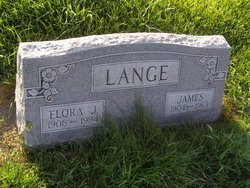
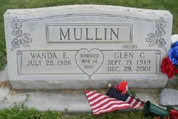
| Description | : | Wanda E. Mullin July 22, 1926 - November 15, 2017 Wanda E. Mullin, 91, of Lexington, Nebraska, died Wednesday, November 15, 2017 at Plum Creek Healthcare Community. Wanda was born July 22, 1926, in Custer County, to James and Flora (Barker) Lange. She attended Redfern Table School in Custer County. Wanda lived on the farm and took care of her younger siblings. Wanda moved to Lexington in 1946, where she started working for the telephone company. On April 14, 1947, she was united in marriage to Glen C. Moon Mullin in Lexington. Four children were blessed to this marriage; Glenda, Paula, Samuel and Carrie.... Read More |
frequently asked questions (FAQ):
-
Where is Wanda Elaine Lange Mullin's memorial?
Wanda Elaine Lange Mullin's memorial is located at: Greenwood Cemetery, Lexington, Dawson County, USA.
-
When did Wanda Elaine Lange Mullin death?
Wanda Elaine Lange Mullin death on 15 Nov 2017 in Lexington, Dawson County, Nebraska, USA
-
Where are the coordinates of the Wanda Elaine Lange Mullin's memorial?
Latitude: 40.7956467
Longitude: -99.7286682
Family Members:
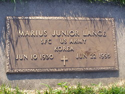
Parent

Spouse
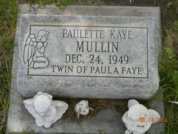
Siblings
Children
Flowers:


Nearby Cemetories:
1. First United Methodist Church Columbarium
Lexington, Dawson County, USA
Coordinate: 40.7810000, -99.7397000
2. Saint Anns Cemetery
Lexington, Dawson County, USA
Coordinate: 40.7789001, -99.7114029
3. Evergreen Cemetery
Lexington, Dawson County, USA
Coordinate: 40.7639008, -99.6791992
4. Mount Hope Cemetery
Dawson County, USA
Coordinate: 40.8293991, -99.6733017
5. Hewitt Cemetery
Lexington, Dawson County, USA
Coordinate: 40.8588982, -99.7769012
6. Buffalo Grove Presbyterian Church Cemetery
Buffalo, Dawson County, USA
Coordinate: 40.8721000, -99.8270000
7. Hillside Cemetery
Dawson County, USA
Coordinate: 40.8946991, -99.7869034
8. Grace Cemetery
Cozad, Dawson County, USA
Coordinate: 40.8602982, -99.8644028
9. Robb Cemetery
Smithfield, Gosper County, USA
Coordinate: 40.6710691, -99.6996001
10. Saint Johns Lutheran Cemetery
Lexington, Dawson County, USA
Coordinate: 40.9019012, -99.8458023
11. Plum Creek Massacre Cemetery
Phelps County, USA
Coordinate: 40.6726840, -99.6058220
12. Overton Cemetery
Overton, Dawson County, USA
Coordinate: 40.7317009, -99.5222015
13. Cozad Cemetery
Cozad, Dawson County, USA
Coordinate: 40.8605995, -99.9475021
14. Quakerville Cemetery
Gosper County, USA
Coordinate: 40.6189003, -99.8097000
15. Cottonwood Cemetery
Dawson County, USA
Coordinate: 40.9322014, -99.9197006
16. Saint Patricks Cemetery
Eddyville, Dawson County, USA
Coordinate: 40.9747009, -99.6093979
17. Adullam Cemetery
Bertrand, Phelps County, USA
Coordinate: 40.6265000, -99.5856000
18. Fairview Cemetery
Dawson County, USA
Coordinate: 40.7719002, -99.9955978
19. Jewell Cemetery
Sumner, Dawson County, USA
Coordinate: 40.9599991, -99.5646973
20. Rose Hill Cemetery
Dawson County, USA
Coordinate: 40.9888992, -99.8442001
21. Elwood Cemetery
Elwood, Gosper County, USA
Coordinate: 40.5999300, -99.8397300
22. Rhinehart Cemetery
Cozad, Dawson County, USA
Coordinate: 40.9599000, -99.9105000
23. Buffalo First Lutheran Cemetery Old
Buffalo, Dawson County, USA
Coordinate: 41.0100000, -99.8152000
24. Buffalo First Lutheran Cemetery New
Buffalo, Dawson County, USA
Coordinate: 41.0127000, -99.8150000