
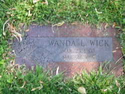
Wanda Lois Haskell Wick
| Birth | : | 25 Mar 1903 Seattle, King County, Washington, USA |
| Death | : | 27 Mar 1991 Omak, Okanogan County, Washington, USA |
| Burial | : | Havelock Cemetery, Havelock, Marlborough District, New Zealand |
| Coordinate | : | -41.2826300, 173.7684800 |
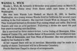
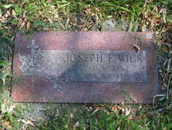
| Description | : | Washington, Births, 1883-1935 Name:Warda Lois Haskell Date of Birth:25 Mar 1903 Gender:Female County:King Father's Name:Frank C Haskell Mother's Name:Ethel May Bantley Wanda L. Wick, 88, formerly of Brewster area passed away on March 27, 1991, at Kim's Home away from Home adult care home in Omak, Washington. She was born Wanda Lois Haskell on March 25, 1903, in Seattle, Washington. As a young woman Wanda lived in California for several years working in the fruit industry. She married Joseph Wick on January 5, 1943. They lived and farmed on Brewster Flat raising wheat and cattle. She loved flowers and was an avid gardener. Following a stroke she spent... Read More |
frequently asked questions (FAQ):
-
Where is Wanda Lois Haskell Wick's memorial?
Wanda Lois Haskell Wick's memorial is located at: Havelock Cemetery, Havelock, Marlborough District, New Zealand.
-
When did Wanda Lois Haskell Wick death?
Wanda Lois Haskell Wick death on 27 Mar 1991 in Omak, Okanogan County, Washington, USA
-
Where are the coordinates of the Wanda Lois Haskell Wick's memorial?
Latitude: -41.2826300
Longitude: 173.7684800
Family Members:
Spouse
Flowers:


Nearby Cemetories:
1. Havelock Cemetery
Havelock, Marlborough District, New Zealand
Coordinate: -41.2826300, 173.7684800
2. Kaiuma Bay Graves
Kaiuma, Marlborough District, New Zealand
Coordinate: -41.2362962, 173.7875701
3. Ruapeka Cemetery
Canvastown, Marlborough District, New Zealand
Coordinate: -41.2883780, 173.6901440
4. Mahakipawa
Linkwater, Marlborough District, New Zealand
Coordinate: -41.2892290, 173.8474970
5. Te Horo Cemetery
Canvastown, Marlborough District, New Zealand
Coordinate: -41.2887942, 173.6652268
6. Deep Creek Cemetery
Deep Creek, Marlborough District, New Zealand
Coordinate: -41.3556480, 173.6320210
7. Rai Valley Cemetery
Rai Valley, Marlborough District, New Zealand
Coordinate: -41.2127080, 173.5802470
8. Picton Cemetery
Picton, Marlborough District, New Zealand
Coordinate: -41.2902300, 173.9976500
9. Picton Gaolyard
Picton, Marlborough District, New Zealand
Coordinate: -41.2933357, 174.0046601
10. Ruakanakana Urupā
Kaituna, Marlborough District, New Zealand
Coordinate: -41.4463616, 173.8779400
11. Maher Family Cemetery
Kaituna, Marlborough District, New Zealand
Coordinate: -41.4682494, 173.7958289
12. Kaituna Cemetery
Kaituna, Marlborough District, New Zealand
Coordinate: -41.4694650, 173.8036590
13. Wairau Affray Graves
Tuamarina, Marlborough District, New Zealand
Coordinate: -41.4285146, 173.9597007
14. Waikawa Urupā
Waikawa, Marlborough District, New Zealand
Coordinate: -41.2739670, 174.0411840
15. Tuamarina Cemetery
Tuamarina, Marlborough District, New Zealand
Coordinate: -41.4280969, 173.9623665
16. Rapaura Community Churchyard
Rapaura, Marlborough District, New Zealand
Coordinate: -41.4724800, 173.8995800
17. Rapaura Anglican Cemetery
Rapaura, Marlborough District, New Zealand
Coordinate: -41.4719700, 173.9014700
18. McLaren's Grave
Nelson City, New Zealand
Coordinate: -41.0722901, 173.6998022
19. Langley Dale Cemetery
Marlborough District, New Zealand
Coordinate: -41.5076952, 173.7025647
20. Pioneers Church Cemetery
Renwick, Marlborough District, New Zealand
Coordinate: -41.5091139, 173.8364765
21. Upper Wairau Valley Cemetery
Blenheim, Marlborough District, New Zealand
Coordinate: -41.5171130, 173.7974110
22. Old Renwick Cemetery
Marlborough District, New Zealand
Coordinate: -41.5014030, 173.8909900
23. Robin Hood Bay Urupā
Marlborough District, New Zealand
Coordinate: -41.3541665, 174.0768701
24. Māori Island Urupā Otamawahu
Grovetown, Marlborough District, New Zealand
Coordinate: -41.4729310, 173.9778908