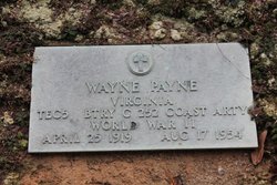
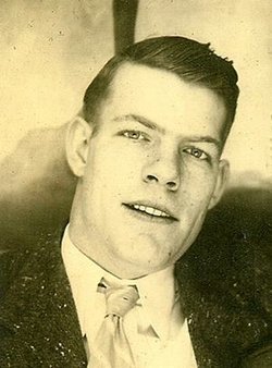
Wayne Frederick Payne
| Birth | : | 25 Apr 1919 |
| Death | : | 17 Aug 1954 |
| Burial | : | Bright Cemetery, Bright, Alpine Shire, Australia |
| Coordinate | : | -36.7347343, 146.9651155 |
| Plot | : | Section 311, Lot A61, Plot 2 |
| Description | : | Wayne Frederick Payne, 35 year old farmer of Lowgap, Route 1, was killed at 2:30 pm Tuesday by a freakish bolt of lightning as he sat on the front porch of a tenant farm house near his home. Mr. Payne had taken refuge on the porch with a group of farm workers when a dark storm cloud came up, interrupting their work in a nearby bean field. Witnesses said the cloud produced only one flash of lightning. The bolt struck Mr. Payne, killing him instantly. The other men on the porch were not hurt, some of them... Read More |
frequently asked questions (FAQ):
-
Where is Wayne Frederick Payne's memorial?
Wayne Frederick Payne's memorial is located at: Bright Cemetery, Bright, Alpine Shire, Australia.
-
When did Wayne Frederick Payne death?
Wayne Frederick Payne death on 17 Aug 1954 in
-
Where are the coordinates of the Wayne Frederick Payne's memorial?
Latitude: -36.7347343
Longitude: 146.9651155
Family Members:
Parent
Siblings
Flowers:
Nearby Cemetories:
1. Bright Cemetery
Bright, Alpine Shire, Australia
Coordinate: -36.7347343, 146.9651155
2. Havilah Cemetery
Havilah, Alpine Shire, Australia
Coordinate: -36.6246280, 146.9308030
3. Buckland Cemetery
Buckland, Alpine Shire, Australia
Coordinate: -36.8250486, 146.8519082
4. Tawonga Public Cemetery
Tawonga, Alpine Shire, Australia
Coordinate: -36.6336400, 147.1023640
5. Harrietville Cemetery
Harrietville, Alpine Shire, Australia
Coordinate: -36.8735670, 147.0570950
6. Myrtleford Lawn Cemetery
Myrtleford, Alpine Shire, Australia
Coordinate: -36.5396460, 146.7533630
7. Myrtleford Cemetery
Myrtleford, Alpine Shire, Australia
Coordinate: -36.5504057, 146.7283316
8. Stanley Pioneer Cemetery
Stanley, Indigo Shire, Australia
Coordinate: -36.4069444, 146.7638890
9. Stanley Cemetery
Stanley, Indigo Shire, Australia
Coordinate: -36.3961111, 146.7477778
10. Granite Flat Cemetery
Buloke Shire, Australia
Coordinate: -36.5824430, 147.4258160
11. Bowmans Forest
Wangaratta Rural City, Australia
Coordinate: -36.4687490, 146.5859640
12. Edi Upper
Edi Upper, Wangaratta Rural City, Australia
Coordinate: -36.7060730, 146.4491390
13. Glen Wills Cemetery
Glen Valley, East Gippsland Shire, Australia
Coordinate: -36.8617380, 147.4893440
14. Yackandandah Cemetery
Yackandandah, Indigo Shire, Australia
Coordinate: -36.3041697, 146.8493387
15. Beechworth Cemetery
Beechworth, Indigo Shire, Australia
Coordinate: -36.3462230, 146.6904710
16. Kiewa Cemetery
Indigo Shire, Australia
Coordinate: -36.2842119, 147.0653848
17. Sandy Creek Cemetery
Wodonga, Wodonga City, Australia
Coordinate: -36.2789210, 147.1071100
18. Yabba Cemetery
Tallangatta, Towong Shire, Australia
Coordinate: -36.3119010, 147.2675550
19. Milawa Cemetery
Milawa, Wangaratta Rural City, Australia
Coordinate: -36.4380710, 146.4378020
20. Tarrawingee Cemetery
Tarrawingee, Wangaratta Rural City, Australia
Coordinate: -36.3898090, 146.4848250
21. El Dorado Cemetery
Eldorado, Wangaratta Rural City, Australia
Coordinate: -36.3127800, 146.5212500
22. Greta Cemetery
Greta, Wangaratta Rural City, Australia
Coordinate: -36.5502562, 146.2757915
23. Tallangatta Cemetery
Tallangatta, Towong Shire, Australia
Coordinate: -36.1988630, 147.2754593
24. Bethanga Cemetery
Bethanga, Towong Shire, Australia
Coordinate: -36.1412640, 147.0847670

