
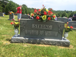
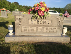
Will Herman “Bouse” Strong
| Birth | : | 2 Apr 1922 Midway, Clay County, Tennessee, USA |
| Death | : | 5 Oct 2002 Celina, Clay County, Tennessee, USA |
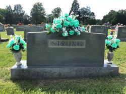
| Burial | : | Macedonia Cemetery, Moss, Clay County, USA |
| Coordinate | : | 36.5643997, -85.6110992 |
| Description | : | WILL HERMAN (BOUSE) STRONG, age 80, of Moss, died October 5, 2002; born April 2, 1922, in Moss, to Barlow Francis STRONG and Rose Ell McBRIDE; married the late, former Minnie Lou LYNN; retired farmer, logger and school bus driver; member of the New Hope Church of Christ; interment in the Macedonia Cemetery. He was the father of Betty Stewart, Ruby Louise Smith, and Jo Nell McLerran. He had four grandchildren, Benet Stewart Theiss, Rachel Stewart Patton, Brian McLerran, and Amy McLerran Dodson. |
frequently asked questions (FAQ):
-
Where is Will Herman “Bouse” Strong's memorial?
Will Herman “Bouse” Strong's memorial is located at: Macedonia Cemetery, Moss, Clay County, USA.
-
When did Will Herman “Bouse” Strong death?
Will Herman “Bouse” Strong death on 5 Oct 2002 in Celina, Clay County, Tennessee, USA
-
Where are the coordinates of the Will Herman “Bouse” Strong's memorial?
Latitude: 36.5643997
Longitude: -85.6110992
Family Members:
Parent
Spouse
Flowers:


Nearby Cemetories:
1. Strong Family Cemetery
Clay County, USA
Coordinate: 36.5690700, -85.6042600
2. McLerran Cemetery
Moss, Clay County, USA
Coordinate: 36.5790000, -85.5973000
3. Kendall Cemetery
Moss, Clay County, USA
Coordinate: 36.5672540, -85.6362650
4. Moss Cemetery
Moss, Clay County, USA
Coordinate: 36.5911210, -85.6214460
5. Eads-Denton Cemetery
Pine Hill, Clay County, USA
Coordinate: 36.5644207, -85.6503187
6. Odle Cemetery
Clay County, USA
Coordinate: 36.5966988, -85.6085968
7. Spear Family Cemetery
Moss, Clay County, USA
Coordinate: 36.5933200, -85.5876500
8. Meadows Cemetery
Clay County, USA
Coordinate: 36.5946999, -85.5875015
9. Smith Cemetery
Pine Hill, Clay County, USA
Coordinate: 36.5714930, -85.6568170
10. Liberty Church Cemetery
Boles, Clay County, USA
Coordinate: 36.6010850, -85.6496830
11. Dalton Cemetery
Arcott, Clay County, USA
Coordinate: 36.5429540, -85.5546170
12. Moore Cemetery
Moss, Clay County, USA
Coordinate: 36.6113400, -85.6374980
13. Walker Reecer Cemetery
Celina, Clay County, USA
Coordinate: 36.5746290, -85.5480270
14. New Hope Cemetery
Clay County, USA
Coordinate: 36.6021996, -85.5653000
15. Archibald Plumlee Cemetery
Pine Hill, Clay County, USA
Coordinate: 36.5203018, -85.5682983
16. Pricetown Cemetery
Clay County, USA
Coordinate: 36.5422500, -85.6750670
17. Willhoite-Curtis Cemetery
Tompkinsville, Monroe County, USA
Coordinate: 36.6182208, -85.6442948
18. Lester Brown Family Cemetery
Arcott, Clay County, USA
Coordinate: 36.5205700, -85.5547530
19. Jonestown Cemetery
Clay County, USA
Coordinate: 36.5619011, -85.6921997
20. McColgan Cemetery
Clay County, USA
Coordinate: 36.5163994, -85.5560989
21. Roberts Cemetery
Celina, Clay County, USA
Coordinate: 36.5066986, -85.5727997
22. Freedom Cemetery #2
Tompkinsville, Monroe County, USA
Coordinate: 36.6284060, -85.6289940
23. Plumlee Cemetery
Celina, Clay County, USA
Coordinate: 36.5694280, -85.5282830
24. Moore Cemetery #1
Moss, Clay County, USA
Coordinate: 36.6164920, -85.6636620