

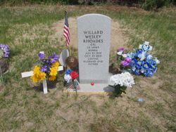
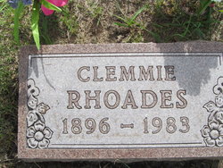
Willard Wesley “Bill” Rhoades
| Birth | : | 22 Jun 1932 Arnold, Custer County, Nebraska, USA |
| Death | : | 29 Oct 2021 Broken Bow, Custer County, Nebraska, USA |
| Burial | : | Moulton Cemetery, Loup County, USA |
| Coordinate | : | 41.8574982, -99.5852966 |
| Description | : | U.S. Veteran Willard Rhoades age 89 of Broken Bow, NE passed away October 29, 2021, at his home in Broken Bow. Funeral services will be held Wednesday November 3, 2021, at 2 p.m. at the Events Center in Taylor, Nebraska. Burial will follow in the Moulton Cemetery with Military Rites in Taylor, NE. Govier Brothers Mortuary are in charge of arrangements. Willard "Bill" Wesley Rhoades, 89, Born June 22, 1932, to Clemmie and Evadna "Duryea" Rhoades, in Arnold, Nebraska. Passed away October 29, 2021 in his home. Bill grew up with his dad, who... Read More |
frequently asked questions (FAQ):
-
Where is Willard Wesley “Bill” Rhoades's memorial?
Willard Wesley “Bill” Rhoades's memorial is located at: Moulton Cemetery, Loup County, USA.
-
When did Willard Wesley “Bill” Rhoades death?
Willard Wesley “Bill” Rhoades death on 29 Oct 2021 in Broken Bow, Custer County, Nebraska, USA
-
Where are the coordinates of the Willard Wesley “Bill” Rhoades's memorial?
Latitude: 41.8574982
Longitude: -99.5852966
Family Members:
Parent
Spouse

Siblings
Flowers:


Nearby Cemetories:
1. Moulton Cemetery
Loup County, USA
Coordinate: 41.8574982, -99.5852966
2. Almeria Cemetery
Almeria, Loup County, USA
Coordinate: 41.8177986, -99.5128021
3. Madison Square Cemetery
Taylor, Loup County, USA
Coordinate: 41.7694016, -99.5314026
4. Taylor Cemetery
Taylor, Loup County, USA
Coordinate: 41.7571983, -99.3861008
5. Predmore Cemetery
Walworth, Custer County, USA
Coordinate: 41.6755981, -99.5674973
6. West Union Cemetery
Sargent, Custer County, USA
Coordinate: 41.6763992, -99.4608002
7. Brewster Cemetery
Brewster, Blaine County, USA
Coordinate: 41.9291992, -99.8419037
8. Gates Cemetery
Gates, Custer County, USA
Coordinate: 41.6492004, -99.6361008
9. Saint Marys Cemetery
Sargent, Custer County, USA
Coordinate: 41.6768990, -99.4044037
10. Mount Hope Cemetery
Sargent, Custer County, USA
Coordinate: 41.6768990, -99.3855972
11. Kent Cemetery
Taylor, Loup County, USA
Coordinate: 41.7416992, -99.3088989
12. German Valley Cemetery
Blaine County, USA
Coordinate: 42.0116997, -99.8313980
13. Victoria Creek Cemetery
Anselmo, Custer County, USA
Coordinate: 41.6255000, -99.7510000
14. Lillian Cemetery
Lillian, Custer County, USA
Coordinate: 41.5925000, -99.6500000
15. Round Valley Cemetery
Custer County, USA
Coordinate: 41.5758018, -99.5180969
16. Somerford Cemetery
Sargent, Custer County, USA
Coordinate: 41.5793991, -99.4328003
17. Jack Shafer Memorial Cemetery
Burwell, Garfield County, USA
Coordinate: 41.8202200, -99.1835500
18. Parker Cemetery
Burwell, Garfield County, USA
Coordinate: 41.8203011, -99.1821976
19. Saint Anselms Cemetery
Anselmo, Custer County, USA
Coordinate: 41.6157990, -99.8442001
20. New Hope Cemetery
Merna, Custer County, USA
Coordinate: 41.5772018, -99.7833023
21. Grandview Cemetery
Anselmo, Custer County, USA
Coordinate: 41.6255962, -99.8944652
22. Littlefield Cemetery
Burwell, Garfield County, USA
Coordinate: 41.8093987, -99.1389008
23. Cottonwood Cemetery
Burwell, Garfield County, USA
Coordinate: 41.7681007, -99.1418991
24. Duff Cemetery
Duff, Rock County, USA
Coordinate: 42.2028008, -99.5935974