
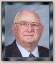


William A. “Bill” Schwindt
| Birth | : | 19 Oct 1930 Gridley, Coffey County, Kansas, USA |
| Death | : | 21 Mar 2011 El Dorado, Butler County, Kansas, USA |
| Burial | : | Union Cemetery, Medford, Steele County, USA |
| Coordinate | : | 44.1893000, -93.2439400 |
| Plot | : | Section: C Lot: 58 Space: W4 |
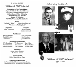
| Description | : | William A. "Bill" Schwindt, 80 of El Dorado went to be with the Lord on March 21, 2011. Bill was born October 19, 1930 in Gridley, Kansas the son of John and Barbara (Vogler) Schwindt. He was united in marriage to Bernadine Kammer at St. Joseph Catholic Church in Topeka, Kansas. He graduated from Topeka High School. During the Korean War he served his country in the United States Marine Division, Recon Company. He was wounded twice and for his valor he was awarded two Purple Hearts and the Silver Star. He moved with his wife Bernadine to El Dorado in... Read More |
frequently asked questions (FAQ):
-
Where is William A. “Bill” Schwindt's memorial?
William A. “Bill” Schwindt's memorial is located at: Union Cemetery, Medford, Steele County, USA.
-
When did William A. “Bill” Schwindt death?
William A. “Bill” Schwindt death on 21 Mar 2011 in El Dorado, Butler County, Kansas, USA
-
Where are the coordinates of the William A. “Bill” Schwindt's memorial?
Latitude: 44.1893000
Longitude: -93.2439400
Family Members:
Parent

Siblings
Children
Flowers:


Nearby Cemetories:
1. Union Cemetery
Medford, Steele County, USA
Coordinate: 44.1893000, -93.2439400
2. Riverside Cemetery
Medford, Steele County, USA
Coordinate: 44.1680984, -93.2542038
3. Resurrection Cemetery
Medford, Steele County, USA
Coordinate: 44.1678009, -93.2611008
4. Medford Trinity Lutheran Cemetery
Medford, Steele County, USA
Coordinate: 44.1828003, -93.3058014
5. Oak Hill Cemetery
Clinton Falls, Steele County, USA
Coordinate: 44.1418991, -93.2493973
6. Eklund Cemetery
Rice County, USA
Coordinate: 44.2182999, -93.1772003
7. Denison Cemetery
Faribault, Rice County, USA
Coordinate: 44.2472000, -93.2628021
8. Owatonna Memorial Gardens
Owatonna, Steele County, USA
Coordinate: 44.1268997, -93.2446976
9. Deerfield Township Cemetery
Steele County, USA
Coordinate: 44.1460991, -93.3199997
10. Woodman Cemetery
Faribault, Rice County, USA
Coordinate: 44.2649994, -93.2556000
11. Richland Cemetery
Rice County, USA
Coordinate: 44.2182999, -93.1425018
12. Hoffman Cemetery
Steele County, USA
Coordinate: 44.1253170, -93.3069210
13. Crane Creek Cemetery
Steele County, USA
Coordinate: 44.1247890, -93.3069990
14. Richland Union Cemetery
Faribault, Rice County, USA
Coordinate: 44.2405340, -93.1567680
15. Meadow Ridge Memorial Park
Faribault, Rice County, USA
Coordinate: 44.2708015, -93.2696991
16. Merton Cemetery
Steele County, USA
Coordinate: 44.1643982, -93.1222000
17. Faribault Regional Center West Cemetery
Walcott, Rice County, USA
Coordinate: 44.2802530, -93.2628560
18. Norwegian Cemetery
Steele County, USA
Coordinate: 44.1319008, -93.3463974
19. Faribault Regional Center East Cemetery
Walcott, Rice County, USA
Coordinate: 44.2824783, -93.2493744
20. Saint John Lutheran Cemetery
Owatonna, Steele County, USA
Coordinate: 44.0956001, -93.2200012
21. Rice County Poor Farm Cemetery
Faribault, Rice County, USA
Coordinate: 44.2760506, -93.3032074
22. Forest Hill Cemetery
Owatonna, Steele County, USA
Coordinate: 44.0938988, -93.2185974
23. State School Childrens Cemetery
Owatonna, Steele County, USA
Coordinate: 44.0882490, -93.2422880
24. Corpus Christi Catholic Cemetery
Deerfield, Steele County, USA
Coordinate: 44.1669388, -93.3827820