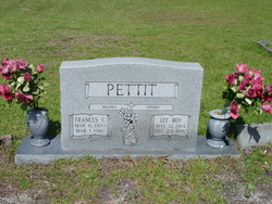
| Birth | : | 22 Feb 1892 |
| Death | : | 5 Mar 1975 Rutherfordton, Rutherford County, North Carolina, USA |
| Burial | : | Fairview Baptist Cemetery, Landrum, Spartanburg County, USA |
| Coordinate | : | 35.1559160, -82.2067330 |
frequently asked questions (FAQ):
-
Where is William Carl “Sam” Pettit's memorial?
William Carl “Sam” Pettit's memorial is located at: Fairview Baptist Cemetery, Landrum, Spartanburg County, USA.
-
When did William Carl “Sam” Pettit death?
William Carl “Sam” Pettit death on 5 Mar 1975 in Rutherfordton, Rutherford County, North Carolina, USA
-
Where are the coordinates of the William Carl “Sam” Pettit's memorial?
Latitude: 35.1559160
Longitude: -82.2067330
Family Members:
Spouse
Children
Flowers:
Nearby Cemetories:
1. Fairview Baptist Cemetery
Landrum, Spartanburg County, USA
Coordinate: 35.1559160, -82.2067330
2. Redeemed Baptist Church Cemetery
Landrum, Spartanburg County, USA
Coordinate: 35.1446750, -82.1945940
3. Evergreen Memorial Gardens
Landrum, Spartanburg County, USA
Coordinate: 35.1535988, -82.1735992
4. Landrum Springs Baptist Church Cemetery
Landrum, Spartanburg County, USA
Coordinate: 35.1843210, -82.2066580
5. Landrum Cemetery
Landrum, Spartanburg County, USA
Coordinate: 35.1777530, -82.1819910
6. Oak Grove Baptist Church Cemetery
Greenville County, USA
Coordinate: 35.1674995, -82.2425003
7. Ingleside Baptist Church Cemetery
Landrum, Spartanburg County, USA
Coordinate: 35.1457580, -82.1684880
8. Bethel Baptist Church Cemetery
Campobello, Spartanburg County, USA
Coordinate: 35.1180010, -82.1933110
9. Belue Cemetery
Gowensville, Greenville County, USA
Coordinate: 35.1516750, -82.2558030
10. Blue Ridge Baptist Church Cemetery
Landrum, Spartanburg County, USA
Coordinate: 35.1515617, -82.2557983
11. First Baptist Church of Gowensville Cemetery
Gowensville, Greenville County, USA
Coordinate: 35.1179619, -82.2240982
12. Pleasant Grove Cemetery
Campobello, Spartanburg County, USA
Coordinate: 35.1197014, -82.1836014
13. Earle Family Cemetery
Landrum, Spartanburg County, USA
Coordinate: 35.1863840, -82.1526480
14. Morgan Chapel Baptist Church Cemetery
Tryon, Polk County, USA
Coordinate: 35.2072880, -82.1804350
15. Tryon United Methodist Church Memorial Garden
Tryon, Polk County, USA
Coordinate: 35.2067010, -82.2349420
16. Episcopal Church of the Holy Cross Memorial Garden
Tryon, Polk County, USA
Coordinate: 35.2074520, -82.2417210
17. Tryon First Baptist Church Memorial Garden
Tryon, Polk County, USA
Coordinate: 35.2081950, -82.2404820
18. Congregational Church of Christ Memorial Garden
Tryon, Polk County, USA
Coordinate: 35.2072280, -82.2426600
19. Campobello United Methodist Church Cemetery
Spartanburg County, USA
Coordinate: 35.1169330, -82.1493710
20. Good Shepherd Episcopal Church Cemetery
Tryon, Polk County, USA
Coordinate: 35.2146988, -82.2292023
21. Tryon Cemetery
Tryon, Polk County, USA
Coordinate: 35.2138710, -82.2329930
22. Rock Springs Baptist Church Cemetery
Greenville County, USA
Coordinate: 35.1941986, -82.2688980
23. Campobello First Baptist Church Cemetery
Campobello, Spartanburg County, USA
Coordinate: 35.1228900, -82.1377880
24. Mountain View Church Of God Of Prophecy Cemetery
Gowensville, Greenville County, USA
Coordinate: 35.0901100, -82.2203300


