
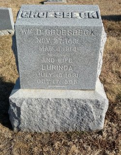
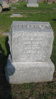
William Daniel Groesbeck
| Birth | : | 27 Nov 1831 Montgomery, Orange County, New York, USA |
| Death | : | 4 Mar 1914 |
| Burial | : | St. Mary's Churchyard, Shelton, South Norfolk District, England |
| Coordinate | : | 52.4720940, 1.2686120 |
| Plot | : | 120OC plot 4 |
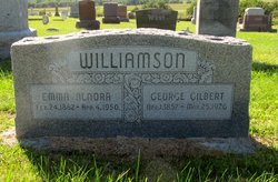
| Description | : | Married Rebecca Chatterton in 1905 at Nebr. City. Roster of Soldiers, Sailors, and Marines of the War of 1812, the Mexican War, and the War of the Rebellion residing in Nebraska June 1, 1891: Unadilla, Private, Co M, 1st Calvary, enlisted in Nebraska. 3-13-1914 The Otoe Union: He leaves a wife and five children, one son and four daughters: Cornelius W. Groesbeck of Imperial NE, Mrs. Calvin Zellers of Elmwood, Mrs. Inez Carper of Nebr. City, Mrs. G.C. Williamson of Murdock and Mrs. W.F. Yeigh of this place. While a child he came with his parents to Illinois and in early manhood moved to... Read More |
frequently asked questions (FAQ):
-
Where is William Daniel Groesbeck's memorial?
William Daniel Groesbeck's memorial is located at: St. Mary's Churchyard, Shelton, South Norfolk District, England.
-
When did William Daniel Groesbeck death?
William Daniel Groesbeck death on 4 Mar 1914 in
-
Where are the coordinates of the William Daniel Groesbeck's memorial?
Latitude: 52.4720940
Longitude: 1.2686120
Family Members:
Spouse

Children
Flowers:


Nearby Cemetories:
1. St. Mary's Churchyard
Shelton, South Norfolk District, England
Coordinate: 52.4720940, 1.2686120
2. Saint Margaret's Churchyard
Hardwick, South Norfolk District, England
Coordinate: 52.4632800, 1.2712440
3. Saint John the Baptist Churchyard
Morningthorpe, South Norfolk District, England
Coordinate: 52.4859170, 1.2654150
4. St Catherine Churchyard
Fritton, Great Yarmouth Borough, England
Coordinate: 52.4919750, 1.2796600
5. Long Stratton Congregational Churchyard
Long Stratton, South Norfolk District, England
Coordinate: 52.4818890, 1.2324460
6. St Mary's Churchyard
Long Stratton, South Norfolk District, England
Coordinate: 52.4840800, 1.2339000
7. St Margaret Churchyard
Hempnall, South Norfolk District, England
Coordinate: 52.5018500, 1.3004810
8. Saint Mary Magdalene Churchyard
Pulham Market, South Norfolk District, England
Coordinate: 52.4285200, 1.2301100
9. St. Michael's Churchyard
Great Moulton, South Norfolk District, England
Coordinate: 52.4718860, 1.1868760
10. Pulham Market Cemetery
Pulham Market, South Norfolk District, England
Coordinate: 52.4281900, 1.2297700
11. St Mary the Virgin Churchyard
Pulham St Mary, South Norfolk District, England
Coordinate: 52.4205290, 1.2520380
12. St Peter Churchyard
Forncett, South Norfolk District, England
Coordinate: 52.4906450, 1.1862950
13. St Mary Churchyard
Forncett, South Norfolk District, England
Coordinate: 52.4994380, 1.1897810
14. All Saints Churchyard
Alburgh, South Norfolk District, England
Coordinate: 52.4362610, 1.3386490
15. St. Mary's Churchyard
Saxlingham Nethergate, South Norfolk District, England
Coordinate: 52.5268910, 1.2880390
16. United Reformed Churchyard
Denton, South Norfolk District, England
Coordinate: 52.4465510, 1.3532090
17. St Michael Churchyard
Aslacton, South Norfolk District, England
Coordinate: 52.4750490, 1.1737040
18. Saint Andrews Churchyard
Bedingham, South Norfolk District, England
Coordinate: 52.4902500, 1.3643180
19. St Michael And All Saint's
Flordon, South Norfolk District, England
Coordinate: 52.5294700, 1.2261400
20. St. Margaret Churchyard
Hapton, South Norfolk District, England
Coordinate: 52.5244110, 1.2066410
21. St. Mary's Churchyard
Denton, South Norfolk District, England
Coordinate: 52.4364500, 1.3618770
22. St Mary's Churchyard
Newton Flotman, South Norfolk District, England
Coordinate: 52.5393520, 1.2617220
23. Church of the Assumption of the Blessed Virgin Mar
Redenhall, South Norfolk District, England
Coordinate: 52.4104780, 1.3272680
24. St Mary Churchyard
Shotesham, South Norfolk District, England
Coordinate: 52.5411110, 1.2985880