
| Birth | : | 15 Nov 1923 |
| Death | : | 12 Jan 2007 |
| Burial | : | Rudd Evergreen Cemetery, Rudd, Floyd County, USA |
| Coordinate | : | 43.1417007, -92.9214020 |
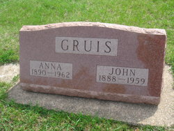
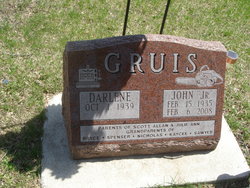
| Description | : | GRUIS, William Earl "Pete" 1923-2007 GRUIS, BENZ, FRANCIS Posted By: K. Kittleson Date: 12/3/2008 at 12:05:57 Visitation: Monday, January 15, 2007 Hauser Funeral Home 1205 South Main Charles City, Iowa Service: Tuesday, January 16, 2007 Rock Creek Lutheran Church Rural Osage, Iowa Earl "Pete" Gruis, 83, of Rudd, died Friday, January 12, 2007, at the Hospice Inpatient Unit in Mason City. William Earl "Pete" Gruis was born November 15, 1923, at Bristow, the son of John and Anna (Benz) Gruis, Sr. Pete was baptized and confirmed at the Zion Lutheran Church in Rockford. He graduated from Rockford High School in 1942. Soon after graduation, he worked a... Read More |
frequently asked questions (FAQ):
-
Where is William Earl “Pete” Gruis's memorial?
William Earl “Pete” Gruis's memorial is located at: Rudd Evergreen Cemetery, Rudd, Floyd County, USA.
-
When did William Earl “Pete” Gruis death?
William Earl “Pete” Gruis death on 12 Jan 2007 in
-
Where are the coordinates of the William Earl “Pete” Gruis's memorial?
Latitude: 43.1417007
Longitude: -92.9214020
Family Members:
Parent

Siblings


Flowers:


Nearby Cemetories:
1. Rudd Evergreen Cemetery
Rudd, Floyd County, USA
Coordinate: 43.1417007, -92.9214020
2. Rock Grove Township Cemetery
Nora Springs, Floyd County, USA
Coordinate: 43.1227989, -92.9880981
3. Ulsterville Cemetery
Ulster Township, Floyd County, USA
Coordinate: 43.0936012, -92.8842010
4. Park Cemetery
Nora Springs, Floyd County, USA
Coordinate: 43.1444016, -92.9982986
5. Eden Presbyterian Cemetery
Meroa, Mitchell County, USA
Coordinate: 43.2131004, -92.9103012
6. Spring Grove Cemetery
Nora Springs, Floyd County, USA
Coordinate: 43.1631012, -93.0211029
7. West End Cemetery
Meroa, Mitchell County, USA
Coordinate: 43.2216682, -92.9250031
8. Riverside Cemetery
Rockford, Floyd County, USA
Coordinate: 43.0578003, -92.9464035
9. Dudley Cemetery
Dudley (historical), Mitchell County, USA
Coordinate: 43.2252998, -92.8743973
10. Rock Creek Cemetery
Meroa, Mitchell County, USA
Coordinate: 43.2352791, -92.9225006
11. Calvary Cemetery
Osage, Mitchell County, USA
Coordinate: 43.2238998, -92.8300018
12. Flood Creek Cemetery
Floyd County, USA
Coordinate: 43.0391998, -92.8538971
13. Tucker Cemetery
Osage, Mitchell County, USA
Coordinate: 43.2494011, -92.8319016
14. West Saint Charles United Methodist Cemetery
Floyd County, USA
Coordinate: 43.0580597, -92.7897186
15. Orchard Cemetery
Orchard, Mitchell County, USA
Coordinate: 43.2249985, -92.7838898
16. Rock Falls Cemetery
Rock Falls, Cerro Gordo County, USA
Coordinate: 43.2122192, -93.0858307
17. Oakwood Cemetery
Floyd, Floyd County, USA
Coordinate: 43.1178017, -92.7307968
18. South Osage Mennonite Church Cemetery
Osage, Mitchell County, USA
Coordinate: 43.2544556, -92.7915573
19. Owens Grove Cemetery
Cerro Gordo County, USA
Coordinate: 43.0825005, -93.1144180
20. Saint Marys Catholic Cemetery
Roseville, Floyd County, USA
Coordinate: 43.0090000, -92.8134000
21. Sacred Heart Cemetery
Osage, Mitchell County, USA
Coordinate: 43.2742004, -92.7917023
22. Howardville Cemetery
Floyd, Floyd County, USA
Coordinate: 43.1866989, -92.7016983
23. Osage Cemetery
Osage, Mitchell County, USA
Coordinate: 43.2916700, -92.8201700
24. Oak Grove Cemetery
Mitchell, Mitchell County, USA
Coordinate: 43.3156013, -92.8707962