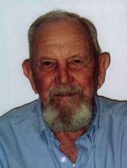
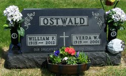
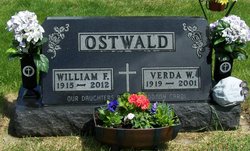
William Fred “Bill” Ostwald
| Birth | : | 30 Mar 1915 Lotts Creek, Kossuth County, Iowa, USA |
| Death | : | 2 Nov 2012 Algona, Kossuth County, Iowa, USA |
| Burial | : | Saint Pauls Lutheran Cemetery, Whittemore, Kossuth County, USA |
| Coordinate | : | 43.0530014, -94.4135971 |
| Description | : | William "Bill" F. R. Ostwald was born March 30, 1915, near Lotts Creek, Iowa, the son of Carl and Mary (Bierstedt) Ostwald. William was baptized April 25, 1915 and confirmed April 13, 1930. He grew up on the family farm near Whittemore and attended country school. After his schooling he stayed home to help his dad on the farm. On June 1, 1938, William was united in marriage to Verda Meyer at St. Paul's Lutheran Church in Whittemore. After their marriage they lived and farmed North of Whittemore, for 42 Years before retiring and moving into Whittemore in 1980. Bill... Read More |
frequently asked questions (FAQ):
-
Where is William Fred “Bill” Ostwald's memorial?
William Fred “Bill” Ostwald's memorial is located at: Saint Pauls Lutheran Cemetery, Whittemore, Kossuth County, USA.
-
When did William Fred “Bill” Ostwald death?
William Fred “Bill” Ostwald death on 2 Nov 2012 in Algona, Kossuth County, Iowa, USA
-
Where are the coordinates of the William Fred “Bill” Ostwald's memorial?
Latitude: 43.0530014
Longitude: -94.4135971
Family Members:
Parent
Spouse
Siblings
Children
Flowers:
Nearby Cemetories:
1. Saint Pauls Lutheran Cemetery
Whittemore, Kossuth County, USA
Coordinate: 43.0530014, -94.4135971
2. Plainview Cemetery
Whittemore, Kossuth County, USA
Coordinate: 43.0667000, -94.4091720
3. Saint Michaels Catholic Cemetery
Whittemore, Kossuth County, USA
Coordinate: 43.0827000, -94.4322500
4. Garfield Township Cemetery
Kossuth County, USA
Coordinate: 42.9947000, -94.4080000
5. Riverside Cemetery
Fern Valley Township, Palo Alto County, USA
Coordinate: 43.0200000, -94.5220000
6. Apostolic V Christian Cemetery
Kossuth County, USA
Coordinate: 42.9630870, -94.4238290
7. Saint John's Lutheran Cemetery
Fairfield Township, Palo Alto County, USA
Coordinate: 43.1265000, -94.5017000
8. West Bend Cemetery
West Bend, Palo Alto County, USA
Coordinate: 42.9590000, -94.4548000
9. Saint Luke's Lutheran Cemetery
Fairfield Township, Palo Alto County, USA
Coordinate: 43.1545000, -94.4723000
10. Immanuel Lutheran Cemetery
Lotts Creek, Kossuth County, USA
Coordinate: 43.1627000, -94.3630000
11. Riverside Cemetery
West Bend, Palo Alto County, USA
Coordinate: 42.9512000, -94.5120000
12. North Saint John's Lutheran Cemetery
Independence Township, Palo Alto County, USA
Coordinate: 43.1696281, -94.5077438
13. East Lawn Cemetery
Algona, Kossuth County, USA
Coordinate: 43.0583000, -94.2249985
14. Riverview Cemetery
Algona, Kossuth County, USA
Coordinate: 43.0766983, -94.2257996
15. Union Township Cemetery
Kossuth County, USA
Coordinate: 43.1417007, -94.2619019
16. Lincoln Cemetery
West Bend, Palo Alto County, USA
Coordinate: 42.9596842, -94.5602466
17. Calvary Cemetery
Algona, Kossuth County, USA
Coordinate: 43.0819016, -94.2114029
18. Fenton Township Cemetery
Lone Rock, Kossuth County, USA
Coordinate: 43.1977997, -94.3535995
19. Fenton United Methodist Cemetery
Fenton, Kossuth County, USA
Coordinate: 43.2052994, -94.4262009
20. Union Cemetery
Ottosen, Humboldt County, USA
Coordinate: 42.8879128, -94.3792496
21. Laurel Hill Cemetery
Irvington, Kossuth County, USA
Coordinate: 43.0017014, -94.1939011
22. Saint Johns Lutheran Cemetery
Fenton, Kossuth County, USA
Coordinate: 43.2239000, -94.4289000
23. Omer-Thorsen Farm Cemetery
Ottosen, Humboldt County, USA
Coordinate: 42.8735742, -94.4085743
24. McKnight Cemetery
Bode, Humboldt County, USA
Coordinate: 42.8635100, -94.4055600

