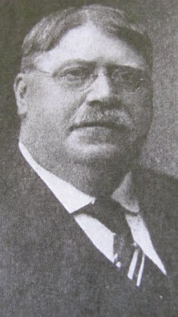
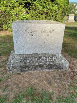
William Frederick Whitcher
| Birth | : | 10 Aug 1845 Benton, Grafton County, New Hampshire, USA |
| Death | : | 31 May 1918 Woodsville, Grafton County, New Hampshire, USA |
| Burial | : | Pine Grove Cemetery, Woodsville, Grafton County, USA |
| Coordinate | : | 44.1380997, -72.0188980 |
| Description | : | Whitcher, William Frederick Clergyman and journalist; b. Benton, N.H., Aug 10, 1845; s. Ira and Lucy (Royce) Whitcher; ed. public schools, N.H. Conference Seminary, Tilton and Weslyan University, Middletown, Conn., graduating from the latter with honors, in 1871; from the Theological Department of Boston University in 1873, and was for nine years a member of the Southern N.E. Methodist Episcopal Conference, holding pastorates in Providence and Newport, R.I., and New Bedford, Mass. Abandoning the ministry he was for eighteen years engaged in journalistic work in Boston, as reporter and editor, first with the Traveler, and later with the Advertiser, with residence... Read More |
frequently asked questions (FAQ):
-
Where is William Frederick Whitcher's memorial?
William Frederick Whitcher's memorial is located at: Pine Grove Cemetery, Woodsville, Grafton County, USA.
-
When did William Frederick Whitcher death?
William Frederick Whitcher death on 31 May 1918 in Woodsville, Grafton County, New Hampshire, USA
-
Where are the coordinates of the William Frederick Whitcher's memorial?
Latitude: 44.1380997
Longitude: -72.0188980
Family Members:
Parent
Spouse
Siblings
Children
Flowers:
Nearby Cemetories:
1. Pine Grove Cemetery
Woodsville, Grafton County, USA
Coordinate: 44.1380997, -72.0188980
2. Wells River Cemetery
Wells River, Orange County, USA
Coordinate: 44.1535988, -72.0547028
3. Horse Meadow Cemetery
North Haverhill, Grafton County, USA
Coordinate: 44.1068880, -72.0405500
4. Horse Meadow Annex Cemetery
North Haverhill, Grafton County, USA
Coordinate: 44.1056820, -72.0408260
5. Carbee Cemetery
Bath, Grafton County, USA
Coordinate: 44.1724640, -72.0466980
6. West Bath Cemetery
Bath, Grafton County, USA
Coordinate: 44.1750930, -71.9865080
7. Swiftwater Cemetery
Bath, Grafton County, USA
Coordinate: 44.1303400, -71.9574300
8. Saint Joseph Cemetery
Bath, Grafton County, USA
Coordinate: 44.1803017, -72.0524979
9. Bath Village Cemetery
Bath, Grafton County, USA
Coordinate: 44.1693500, -71.9617800
10. Boltonville Cemetery
Boltonville, Orange County, USA
Coordinate: 44.1575012, -72.0877991
11. Oxbow Cemetery
Newbury, Orange County, USA
Coordinate: 44.0881830, -72.0486670
12. Carbee District Cemetery
Bath, Grafton County, USA
Coordinate: 44.1881040, -72.0521310
13. Abbott Cemetery
North Haverhill, Grafton County, USA
Coordinate: 44.0821730, -72.0186420
14. Center Haverhill Cemetery
Center Haverhill, Grafton County, USA
Coordinate: 44.0770650, -71.9868740
15. Bedel Cemetery
Bath, Grafton County, USA
Coordinate: 44.2075000, -72.0455560
16. Pettyboro District Cemetery
Pettyboro, Grafton County, USA
Coordinate: 44.2038310, -71.9620880
17. Old Scotch Cemetery
Ryegate, Caledonia County, USA
Coordinate: 44.1969000, -72.0928600
18. Upper Smith Road Cemetery
Bath, Grafton County, USA
Coordinate: 44.2202780, -72.0075000
19. Town House Cemetery
Newbury Center, Orange County, USA
Coordinate: 44.1066322, -72.1256943
20. Manchester Family Cemetery
Ryegate, Caledonia County, USA
Coordinate: 44.2153625, -72.0713120
21. West Cemetery
Benton, Grafton County, USA
Coordinate: 44.1033700, -71.9014000
22. Pinehurst Cemetery
Ryegate, Caledonia County, USA
Coordinate: 44.1856003, -72.1280975
23. Jefferson Hill Cemetery
Newbury, Orange County, USA
Coordinate: 44.1658400, -72.1424200
24. Blue Mountain Cemetery
Ryegate Corner, Caledonia County, USA
Coordinate: 44.2081000, -72.1058700


